Distance between Hailsham and Winterton
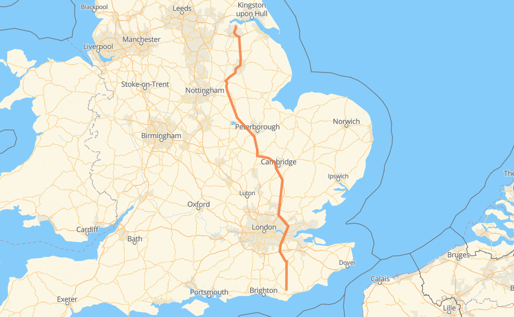
The distance from Hailsham to Winterton is 381 kilometers by road including 127 kilometers on motorways. Road takes approximately 3 hours and 58 minutes and goes through London, Heathfield, Brook Street, Bessels Green, West Thurrock, Stamford and Newark on Trent.
| Shortest distance by air | 316 km ✈️ |
| Car route length | 381 km 🚗 |
| Driving time | 3 h 58 min |
| Fuel amount | 30.5 L |
| Fuel cost | 52.8 GBP |
| Point | Distance | Time | Fuel | |
| Hailsham | 0 km | 00 min | 0.0 L | |
|
B2104 A267 13 km, 10 min
|
||||
| Heathfield | 13 km | 10 min | 0.9 L | |
|
A267 30 km, 25 min
|
||||
| Brook Street | 43 km | 35 min | 3.3 L | |
|
A21 13 km, 08 min
|
||||
| Bessels Green | 56 km | 44 min | 4.4 L | |
|
A21 M25 26 km, 15 min
|
||||
| West Thurrock | 83 km | 59 min | 6.4 L | |
|
A282 M25 13 km, 07 min
|
||||
| London | 95 km | 1 h 06 min | 6.8 L | |
|
M25 M11 152 km, 1 h 26 min
|
||||
| Stamford | 247 km | 2 h 32 min | 19.6 L | |
|
A1 56 km, 35 min
|
||||
| Newark on Trent | 304 km | 3 h 08 min | 24.0 L | |
|
A1 A15 68 km, 43 min
|
||||
| New Frodingham | 371 km | 3 h 51 min | 29.6 L | |
|
A1029 A1077 10 km, 06 min
|
||||
| Winterton | 381 km | 3 h 58 min | 30.3 L | |
Frequently Asked Questions
How much does it cost to drive from Hailsham to Winterton?
Fuel cost: 52.8 GBP
This fuel cost is calculated as: (Route length 381 km / 100 km) * (Fuel consumption 8.00 L/100 km) * (Fuel price 1.73 GBP / L)
You can adjust fuel consumption and fuel price here.
How long is a car ride from Hailsham to Winterton?
Driving time: 3 h 58 min
This time is calculated for driving at the maximum permitted speed, taking into account traffic rules restrictions.
- 127 km with a maximum speed 112 km/h = 1 h 8 min
- 208 km with a maximum speed 96 km/h = 2 h 9 min
- 16 km with a maximum speed 80 km/h = 12 min
- 12 km with a maximum speed 80 km/h = 9 min
- 8 km with a maximum speed 64 km/h = 7 min
- 1 km with a maximum speed 50 km/h = 1 min
- 8 km with a maximum speed 48 km/h = 10 min
The calculated driving time does not take into account intermediate stops and traffic jams.
How far is Hailsham to Winterton by land?
The distance between Hailsham and Winterton is 381 km by road including 127 km on motorways.
Precise satellite coordinates of highways were used for this calculation. The start and finish points are the centers of Hailsham and Winterton respectively.
How far is Hailsham to Winterton by plane?
The shortest distance (air line, as the crow flies) between Hailsham and Winterton is 316 km.
This distance is calculated using the Haversine formula as a great-circle distance between two points on the surface of a sphere. The start and finish points are the centers of Hailsham and Winterton respectively. Actual distance between airports may be different.
How many hours is Hailsham from Winterton by plane?
Boeing 737 airliner needs 23 min to cover the distance of 316 km at a cruising speed of 800 km/h.
Small plane "Cessna 172" needs 1 h 26 min to flight this distance at average speed of 220 km/h.
This time is approximate and do not take into account takeoff and landing times, airport location and other real world factors.
How long is a helicopter ride from Hailsham to Winterton?
Fast helicopter "Eurocopter AS350" or "Hughes OH-6 Cayuse" need 1 h 19 min to cover the distance of 316 km at a cruising speed of 240 km/h.
Popular "Robinson R44" needs 1 h 30 min to flight this distance at average speed of 210 km/h.
This time is approximate and do not take into account takeoff and landing times, aerodrome location and other real world factors.
What city is halfway between Hailsham and Winterton?
The halfway point between Hailsham and Winterton is Conington. It is located about 2 km from the exact midpoint by road.
The distance from Conington to Hailsham is 193 km and driving will take about 1 h 59 min. The road between Conington and Winterton has length 189 km and will take approximately 1 h 59 min.
The other cities located close to halfway point:
Where is Hailsham in relation to Winterton?
Hailsham is located 316 km south-east of Winterton.
Hailsham has geographic coordinates: latitude 50.86469, longitude 0.25792.
Winterton has geographic coordinates: latitude 53.65551, longitude -0.59909.