Distance between Anchorage AK and Seattle WA
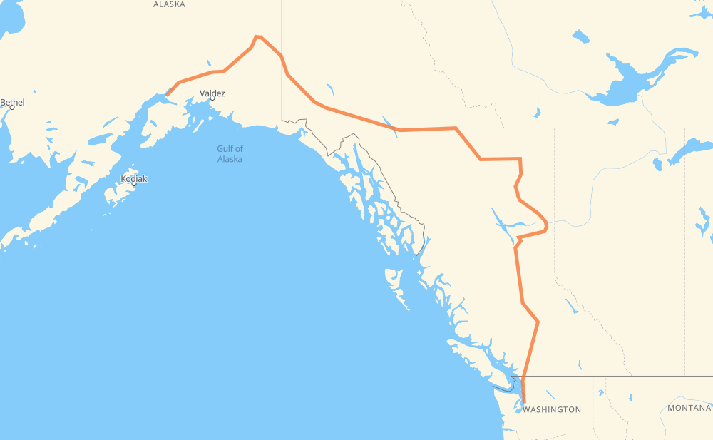
The distance from Anchorage to Seattle is 3,798 kilometers by road including 273 kilometers on motorways. Road takes approximately 41 hours and 58 minutes and goes through Whitehorse, Fort St. John, Prince George, Quesnel, Williams Lake, Chilliwack and Abbotsford.
| Shortest distance by air | 2,309 km ✈️ |
| Car route length | 3,798 km 🚗 |
| Driving time | 41 h 58 min |
| Fuel amount | 303.8 L |
| Fuel cost | 452.7 GBP |
| Point | Distance | Time | Fuel | |
| Anchorage | 0 km | 00 min | 0.0 L | |
|
AK 1 1,136 km, 12 h 35 min
|
||||
| Whitehorse | 1,136 km | 12 h 35 min | 90.4 L | |
|
1 97 1,328 km, 14 h 32 min
|
||||
| Fort St. John | 2,464 km | 27 h 08 min | 196.7 L | |
|
97 433 km, 4 h 56 min
|
||||
| Prince George | 2,897 km | 32 h 04 min | 230.8 L | |
|
97 125 km, 1 h 23 min
|
||||
| Quesnel | 3,021 km | 33 h 28 min | 241.2 L | |
|
97 116 km, 1 h 16 min
|
||||
| Williams Lake | 3,137 km | 34 h 44 min | 250.1 L | |
|
97 1 445 km, 4 h 55 min
|
||||
| Chilliwack | 3,582 km | 39 h 40 min | 285.4 L | |
|
1 25 km, 15 min
|
||||
| Abbotsford | 3,608 km | 39 h 56 min | 287.8 L | |
|
1 WA 9 53 km, 39 min
|
||||
| Bellingham | 3,661 km | 40 h 36 min | 292.0 L | |
|
I 5 93 km, 54 min
|
||||
| Everett | 3,754 km | 41 h 30 min | 299.6 L | |
|
I 5 44 km, 27 min
|
||||
| Seattle | 3,798 km | 41 h 58 min | 302.6 L | |
Hotels of Seattle
Frequently Asked Questions
How much does it cost to drive from Anchorage to Seattle?
Fuel cost: 452.7 GBP
This fuel cost is calculated as: (Route length 3,798 km / 100 km) * (Fuel consumption 8 L/100 km) * (Fuel price 1.49 GBP / L)
You can adjust fuel consumption and fuel price here.
How long is a car ride from Anchorage to Seattle?
Driving time: 41 h 58 min
This time is calculated for driving at the maximum permitted speed, taking into account traffic rules restrictions.
- 52 km with a maximum speed 112 km/h = 27 min
- 2 km with a maximum speed 110 km/h = 1 min
- 47 km with a maximum speed 105 km/h = 26 min
- 78 km with a maximum speed 100 km/h = 47 min
- 91 km with a maximum speed 97 km/h = 56 min
- 2,275 km with a maximum speed 96 km/h = 23 h 41 min
- 155 km with a maximum speed 90 km/h = 1 h 43 min
- 160 km with a maximum speed 89 km/h = 1 h 48 min
- 25 km with a maximum speed 80 km/h = 18 min
- 820 km with a maximum speed 80 km/h = 10 h 14 min
- 6 km with a maximum speed 72 km/h = 4 min
- 36 km with a maximum speed 70 km/h = 31 min
- 6 km with a maximum speed 64 km/h = 5 min
- 17 km with a maximum speed 60 km/h = 16 min
- 11 km with a maximum speed 56 km/h = 11 min
- 16 km with a maximum speed 50 km/h = 19 min
- 1 km with a maximum speed 40 km/h = 2 min
The calculated driving time does not take into account intermediate stops and traffic jams.
How far is Anchorage to Seattle by land?
The distance between Anchorage and Seattle is 3,798 km by road including 273 km on motorways.
Precise satellite coordinates of highways were used for this calculation. The start and finish points are the centers of Anchorage and Seattle respectively.
How far is Anchorage to Seattle by plane?
The shortest distance (air line, as the crow flies) between Anchorage and Seattle is 2,309 km.
This distance is calculated using the Haversine formula as a great-circle distance between two points on the surface of a sphere. The start and finish points are the centers of Anchorage and Seattle respectively. Actual distance between airports may be different.
How many hours is Anchorage from Seattle by plane?
Boeing 737 airliner needs 2 h 53 min to cover the distance of 2,309 km at a cruising speed of 800 km/h.
Small plane "Cessna 172" needs 10 h 29 min to flight this distance at average speed of 220 km/h.
This time is approximate and do not take into account takeoff and landing times, airport location and other real world factors.
How long is a helicopter ride from Anchorage to Seattle?
Fast helicopter "Eurocopter AS350" or "Hughes OH-6 Cayuse" need 9 h 37 min to cover the distance of 2,309 km at a cruising speed of 240 km/h.
Popular "Robinson R44" needs 10 h 59 min to flight this distance at average speed of 210 km/h.
This time is approximate and do not take into account takeoff and landing times, aerodrome location and other real world factors.
What city is halfway between Anchorage and Seattle?
The halfway point between Anchorage and Seattle is Toad River. It is located about 7 km from the exact midpoint by road.
The distance from Toad River to Anchorage is 1,892 km and driving will take about 20 h 54 min. The road between Toad River and Seattle has length 1,906 km and will take approximately 21 h 3 min.
The other cities located close to halfway point:
Where is Anchorage in relation to Seattle?
Anchorage is located 2,309 km north-west of Seattle.
Anchorage has geographic coordinates: latitude 61.21631, longitude -149.89485.
Seattle has geographic coordinates: latitude 47.60383, longitude -122.33006.
Which highway goes from Anchorage to Seattle?
The route from Anchorage to Seattle follows 97, 1, AK 1, AK 2, I 5.
Other minor sections pass along the road:
- 2: 75 km
- AK 4: 22 km
- WA 9: 12 km
- I 5 Express: 11 km
- WA 542: 8 km
- WA 544: 6 km
- 97C: 4 km
- 11: 4 km
- 29: 3 km
- AK 3: 3 km