Distance between Andabamba and San Pablo de Tushmo
The distance from Andabamba to San Pablo de Tushmo is 757 kilometers by road. Road takes approximately 12 hours and 35 minutes and goes through Huancayo, Pucallpa, Paucara, Jauja, Tarmatambo, Hualhuas and Acobamba.
| Shortest distance by air | 483 km ✈️ |
| Car route length | 757 km 🚗 |
| Driving time | 12 h 35 min |
| Fuel amount | 60.5 L |
| Fuel cost | 89.6 GBP |
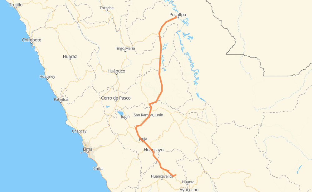
| Point | Distance | Time | Fuel | |
| Andabamba | 0 km | 00 min | 0.0 L | |
|
HV-106 18 km, 13 min
|
||||
| Paucara | 18 km | 13 min | 0.2 L | |
|
HV-106 PE-3S 172 km, 2 h 33 min
|
||||
| Huancayo | 189 km | 2 h 47 min | 13.1 L | |
|
PE-3SB PE-3S 37 km, 27 min
|
||||
| Jauja | 226 km | 3 h 14 min | 17.2 L | |
|
PE-3SA 56 km, 46 min
|
||||
| Hualhuas | 282 km | 4 h 01 min | 22.5 L | |
|
PE-22B 9 km, 06 min
|
||||
| Acobamba | 291 km | 4 h 07 min | 22.6 L | |
|
PE-22B 10 km, 07 min
|
||||
| Palca | 301 km | 4 h 15 min | 23.9 L | |
|
PE-22B 39 km, 31 min
|
||||
| San Ramón | 340 km | 4 h 46 min | 26.6 L | |
|
PE-22B 16 km, 15 min
|
||||
| Kimiri | 356 km | 5 h 02 min | 28.2 L | |
|
PE-22B PE-5N 417 km, 7 h 33 min
|
||||
| San Pablo de Tushmo | 773 km | 12 h 35 min | 61.7 L | |
Frequently Asked Questions
How much does it cost to drive from Andabamba to San Pablo de Tushmo?
Fuel cost: 89.6 GBP
This fuel cost is calculated as: (Route length 757 km / 100 km) * (Fuel consumption 8 L/100 km) * (Fuel price 1.48 GBP / L)
You can adjust fuel consumption and fuel price here.
How long is a car ride from Andabamba to San Pablo de Tushmo?
Driving time: 12 h 35 min
This time is calculated for driving at the maximum permitted speed, taking into account traffic rules restrictions.
- 115 km with a maximum speed 96 km/h = 1 h 11 min
- 40 km with a maximum speed 90 km/h = 26 min
- 208 km with a maximum speed 80 km/h = 2 h 36 min
- 138 km with a maximum speed 60 km/h = 2 h 17 min
- 153 km with a maximum speed 50 km/h = 3 h 3 min
- 107 km with a maximum speed 40 km/h = 2 h 41 min
- 9 km with a maximum speed 35 km/h = 15 min
- 1 km with a maximum speed 30 km/h = 2 min
The calculated driving time does not take into account intermediate stops and traffic jams.
How far is Andabamba to San Pablo de Tushmo by land?
The distance between Andabamba and San Pablo de Tushmo is 757 km by road.
Precise satellite coordinates of highways were used for this calculation. The start and finish points are the centers of Andabamba and San Pablo de Tushmo respectively.
How far is Andabamba to San Pablo de Tushmo by plane?
The shortest distance (air line, as the crow flies) between Andabamba and San Pablo de Tushmo is 483 km.
This distance is calculated using the Haversine formula as a great-circle distance between two points on the surface of a sphere. The start and finish points are the centers of Andabamba and San Pablo de Tushmo respectively. Actual distance between airports may be different.
How many hours is Andabamba from San Pablo de Tushmo by plane?
Boeing 737 airliner needs 36 min to cover the distance of 483 km at a cruising speed of 800 km/h.
Small plane "Cessna 172" needs 2 h 11 min to flight this distance at average speed of 220 km/h.
This time is approximate and do not take into account takeoff and landing times, airport location and other real world factors.
How long is a helicopter ride from Andabamba to San Pablo de Tushmo?
Fast helicopter "Eurocopter AS350" or "Hughes OH-6 Cayuse" need 2 h to cover the distance of 483 km at a cruising speed of 240 km/h.
Popular "Robinson R44" needs 2 h 18 min to flight this distance at average speed of 210 km/h.
This time is approximate and do not take into account takeoff and landing times, aerodrome location and other real world factors.
What city is halfway between Andabamba and San Pablo de Tushmo?
The halfway point between Andabamba and San Pablo de Tushmo is San Luis de Shuaro.
The distance from San Luis de Shuaro to Andabamba is 378 km and driving will take about 5 h 22 min. The road between San Luis de Shuaro and San Pablo de Tushmo has length 379 km and will take approximately 7 h 13 min.
The other cities located close to halfway point:
Where is Andabamba in relation to San Pablo de Tushmo?
Andabamba is located 483 km south of San Pablo de Tushmo.
Andabamba has geographic coordinates: latitude -12.69377, longitude -74.62378.
San Pablo de Tushmo has geographic coordinates: latitude -8.3527, longitude -74.59458.
Which highway goes from Andabamba to San Pablo de Tushmo?
The route from Andabamba to San Pablo de Tushmo follows PE-5N.
Other minor sections pass along the road:
- PE-22B: 85 km
- PE-3S: 82 km
- PE-18C: 79 km
- PE-3SM: 67 km
- PE-3SA: 62 km
- PE-3SB: 40 km
- HV-106: 26 km