Distance between Antônio Prado and São José do Vale do Rio Preto
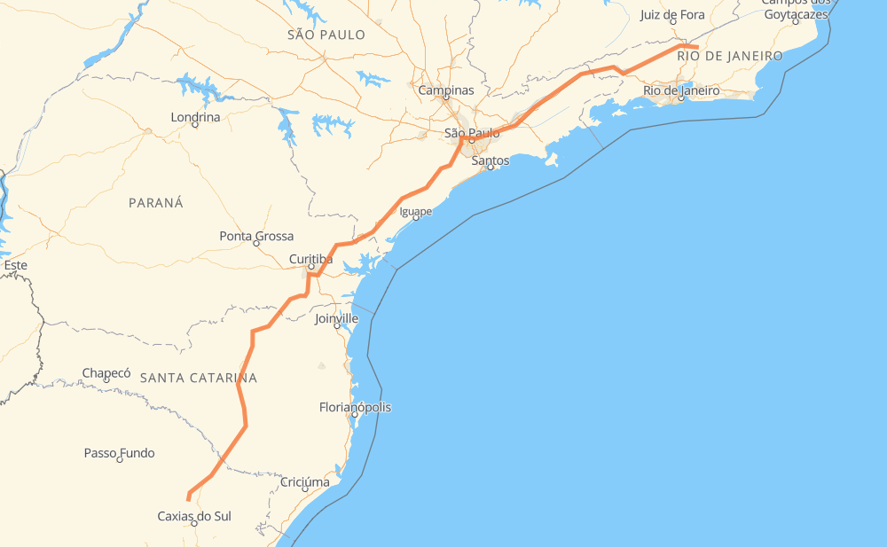
The distance from Antônio Prado to São José do Vale do Rio Preto is 1,429 kilometers by road including 772 kilometers on motorways. Road takes approximately 15 hours and 49 minutes and goes through Piraquara, Taboão da Serra, Jacareí and Guaratinguetá.
| Shortest distance by air | 1,122 km ✈️ |
| Car route length | 1,429 km 🚗 |
| Driving time | 15 h 49 min |
| Fuel amount | 114.4 L |
| Fuel cost | 170.4 GBP |
| Point | Distance | Time | Fuel | |
| Antônio Prado | 0 km | 00 min | 0.0 L | |
|
ERS-122 72 km, 48 min
|
||||
| Passo da Porteira | 72 km | 48 min | 5.7 L | |
|
BR-116 4 km, 03 min
|
||||
| Distrito Industrial II | 76 km | 52 min | 5.8 L | |
|
BR-116 89 km, 1 h 08 min
|
||||
| Área Industrial | 165 km | 2 h 00 min | 13.2 L | |
|
BR-116 9 km, 07 min
|
||||
| CDL | 175 km | 2 h 07 min | 13.8 L | |
|
BR-116 303 km, 3 h 19 min
|
||||
| Queimados II | 478 km | 5 h 26 min | 38.0 L | |
|
BR-116 61 km, 37 min
|
||||
| Piraquara | 540 km | 6 h 04 min | 42.5 L | |
|
BR-116 381 km, 4 h 05 min
|
||||
| Taboão da Serra | 920 km | 10 h 09 min | 73.6 L | |
|
SP-230 SP-070 114 km, 1 h 10 min
|
||||
| Jacareí | 1,035 km | 11 h 19 min | 82.5 L | |
|
SP-070 SP-060 103 km, 1 h 00 min
|
||||
| Guaratinguetá | 1,138 km | 12 h 19 min | 90.8 L | |
|
SP-060 BR-393 309 km, 3 h 29 min
|
||||
| -22.15100, -42.92400 | 1,447 km | 15 h 48 min | 115.8 L | |
Frequently Asked Questions
How much does it cost to drive from Antônio Prado to São José do Vale do Rio Preto?
Fuel cost: 170.4 GBP
This fuel cost is calculated as: (Route length 1,429 km / 100 km) * (Fuel consumption 8 L/100 km) * (Fuel price 1.49 GBP / L)
You can adjust fuel consumption and fuel price here.
How long is a car ride from Antônio Prado to São José do Vale do Rio Preto?
Driving time: 15 h 49 min
This time is calculated for driving at the maximum permitted speed, taking into account traffic rules restrictions.
- 105 km with a maximum speed 112 km/h = 55 min
- 348 km with a maximum speed 110 km/h = 3 h 9 min
- 162 km with a maximum speed 100 km/h = 1 h 37 min
- 431 km with a maximum speed 96 km/h = 4 h 29 min
- 24 km with a maximum speed 90 km/h = 16 min
- 253 km with a maximum speed 80 km/h = 3 h 9 min
- 24 km with a maximum speed 70 km/h = 20 min
- 77 km with a maximum speed 60 km/h = 1 h 17 min
- 9 km with a maximum speed 50 km/h = 11 min
- 13 km with a maximum speed 40 km/h = 19 min
- 1 km with a maximum speed 30 km/h = 2 min
The calculated driving time does not take into account intermediate stops and traffic jams.
How far is Antônio Prado to São José do Vale do Rio Preto by land?
The distance between Antônio Prado and São José do Vale do Rio Preto is 1,429 km by road including 772 km on motorways.
Precise satellite coordinates of highways were used for this calculation. The start and finish points are the centers of Antônio Prado and São José do Vale do Rio Preto respectively.
How far is Antônio Prado to São José do Vale do Rio Preto by plane?
The shortest distance (air line, as the crow flies) between Antônio Prado and São José do Vale do Rio Preto is 1,122 km.
This distance is calculated using the Haversine formula as a great-circle distance between two points on the surface of a sphere. The start and finish points are the centers of Antônio Prado and São José do Vale do Rio Preto respectively. Actual distance between airports may be different.
How many hours is Antônio Prado from São José do Vale do Rio Preto by plane?
Boeing 737 airliner needs 1 h 24 min to cover the distance of 1,122 km at a cruising speed of 800 km/h.
Small plane "Cessna 172" needs 5 h 6 min to flight this distance at average speed of 220 km/h.
This time is approximate and do not take into account takeoff and landing times, airport location and other real world factors.
How long is a helicopter ride from Antônio Prado to São José do Vale do Rio Preto?
Fast helicopter "Eurocopter AS350" or "Hughes OH-6 Cayuse" need 4 h 40 min to cover the distance of 1,122 km at a cruising speed of 240 km/h.
Popular "Robinson R44" needs 5 h 20 min to flight this distance at average speed of 210 km/h.
This time is approximate and do not take into account takeoff and landing times, aerodrome location and other real world factors.
What city is halfway between Antônio Prado and São José do Vale do Rio Preto?
The halfway point between Antônio Prado and São José do Vale do Rio Preto is Rio Azeite. It is located about 6 km from the exact midpoint by road.
The distance from Rio Azeite to Antônio Prado is 709 km and driving will take about 8 h 4 min. The road between Rio Azeite and São José do Vale do Rio Preto has length 720 km and will take approximately 7 h 44 min.
The other cities located close to halfway point:
Where is Antônio Prado in relation to São José do Vale do Rio Preto?
Antônio Prado is located 1,122 km south-west of São José do Vale do Rio Preto.
Antônio Prado has geographic coordinates: latitude -28.85449, longitude -51.28038.
São José do Vale do Rio Preto has geographic coordinates: latitude -22.151, longitude -42.924.
Which highway goes from Antônio Prado to São José do Vale do Rio Preto?
The route from Antônio Prado to São José do Vale do Rio Preto follows BR-116, SP-230, BR-393, SP-060, SP-070.
Other minor sections pass along the road:
- BR-478: 48 km
- ERS-122: 42 km
- BR-492: 34 km
- RJ-134: 34 km
- SP-015: 22 km
- BR-277: 22 km
- BR-040: 18 km
- BR-459: 14 km
- SP-021: 13 km
- BR-383: 11 km
- BR-050: 7 km
- BR-477: 6 km
- SP-280: 4 km
- BR-374: 4 km
- SPI 117/070: 3 km
- ERS-437: 3 km
- SPM-280 E: 2 km
- RJ-151: 2 km
- SPI-016/021: 2 km
- RJ-157: 1 km