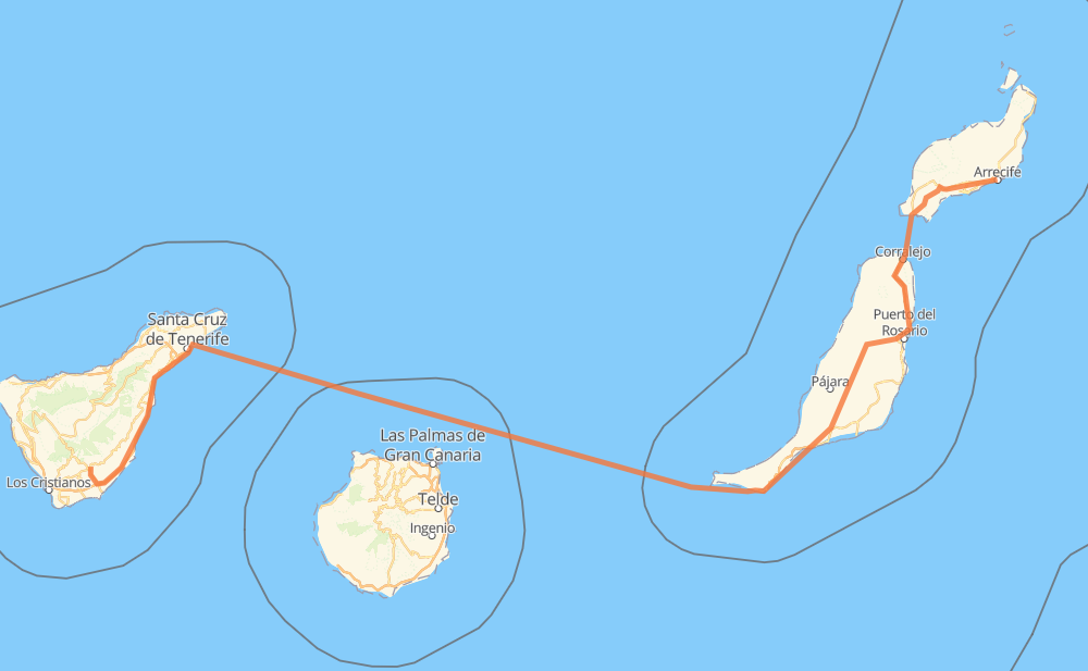
Distance between Arrecife and Granadilla de Abona
The distance from Arrecife to Granadilla de Abona is 426 kilometers by road including 93 kilometers on motorways. Road takes approximately 12 hours and 51 minutes and goes through La Vega, Arrecife Centro, San Francisco Javier, Las Salinas, Urbanización Playa del Cable, Playa Blanca and Corralejo.
| Shortest distance by air | 310 km ✈️ |
| Car route length | 426 km 🚗 |
| Driving time | 12 h 51 min |
| Fuel amount | 34.1 L |
| Fuel cost | 50.8 GBP |
| Point | Distance | Time | Fuel | |
| La Vega | 0 km | 00 min | 0.0 L | |
|
2 km, 01 min
|
||||
| San Francisco Javier | 2 km | 01 min | 0.1 L | |
|
LZ-2 1 km, 00 min
|
||||
| Urbanización Playa del Cable | 3 km | 02 min | 0.2 L | |
|
LZ-2 28 km, 19 min
|
||||
| Playa Blanca | 31 km | 21 min | 2.1 L | |
|
M-3403 21 km, 50 min
|
||||
| Corralejo | 51 km | 1 h 11 min | 4.0 L | |
|
FV-1 13 km, 10 min
|
||||
| Villaverde | 64 km | 1 h 21 min | 4.7 L | |
|
FV-1 13 km, 08 min
|
||||
| Puerto Lajas | 77 km | 1 h 30 min | 5.8 L | |
|
FV-1 FV-20 13 km, 08 min
|
||||
| Tesjuates | 90 km | 1 h 39 min | 7.1 L | |
|
FV-20 8 km, 05 min
|
||||
| La Ampuyenta | 98 km | 1 h 45 min | 7.6 L | |
|
FV-20 11 km, 07 min
|
||||
| Tiscamanita | 109 km | 1 h 52 min | 8.2 L | |
|
FV-20 TF-1 318 km, 10 h 58 min
|
||||
| 28.12214, -16.57667 | 426 km | 12 h 51 min | 34.1 L | |
Hotels of Granadilla de Abona
Frequently Asked Questions
How much does it cost to drive from Arrecife to Granadilla de Abona?
Fuel cost: 50.8 GBP
This fuel cost is calculated as: (Route length 426 km / 100 km) * (Fuel consumption 8 L/100 km) * (Fuel price 1.49 GBP / L)
You can adjust fuel consumption and fuel price here.
How long is a car ride from Arrecife to Granadilla de Abona?
Driving time: 12 h 51 min
This time is calculated for driving at the maximum permitted speed, taking into account traffic rules restrictions.
- 47 km with a maximum speed 112 km/h = 25 min
- 5 km with a maximum speed 110 km/h = 2 min
- 35 km with a maximum speed 100 km/h = 20 min
- 20 km with a maximum speed 96 km/h = 12 min
- 63 km with a maximum speed 90 km/h = 42 min
- 31 km with a maximum speed 80 km/h = 22 min
- 3 km with a maximum speed 60 km/h = 3 min
- 9 km with a maximum speed 50 km/h = 11 min
- 5 km with a maximum speed 40 km/h = 7 min
- 1 km with a maximum speed 30 km/h = 2 min
- 207 km with a maximum speed 20 km/h = 10 h 20 min
The calculated driving time does not take into account intermediate stops and traffic jams.
How far is Arrecife to Granadilla de Abona by land?
The distance between Arrecife and Granadilla de Abona is 426 km by road including 93 km on motorways.
Precise satellite coordinates of highways were used for this calculation. The start and finish points are the centers of Arrecife and Granadilla de Abona respectively.
How far is Arrecife to Granadilla de Abona by plane?
The shortest distance (air line, as the crow flies) between Arrecife and Granadilla de Abona is 310 km.
This distance is calculated using the Haversine formula as a great-circle distance between two points on the surface of a sphere. The start and finish points are the centers of Arrecife and Granadilla de Abona respectively. Actual distance between airports may be different.
How many hours is Arrecife from Granadilla de Abona by plane?
Boeing 737 airliner needs 23 min to cover the distance of 310 km at a cruising speed of 800 km/h.
Small plane "Cessna 172" needs 1 h 24 min to flight this distance at average speed of 220 km/h.
This time is approximate and do not take into account takeoff and landing times, airport location and other real world factors.
How long is a helicopter ride from Arrecife to Granadilla de Abona?
Fast helicopter "Eurocopter AS350" or "Hughes OH-6 Cayuse" need 1 h 17 min to cover the distance of 310 km at a cruising speed of 240 km/h.
Popular "Robinson R44" needs 1 h 28 min to flight this distance at average speed of 210 km/h.
This time is approximate and do not take into account takeoff and landing times, aerodrome location and other real world factors.
What city is halfway between Arrecife and Granadilla de Abona?
The halfway point between Arrecife and Granadilla de Abona is Morro Jable. It is located about 47 km from the exact midpoint by road.
The distance from Morro Jable to Arrecife is 167 km and driving will take about 2 h 33 min. The road between Morro Jable and Granadilla de Abona has length 260 km and will take approximately 10 h 17 min.
The other cities located close to halfway point:
Where is Arrecife in relation to Granadilla de Abona?
Arrecife is located 310 km north-east of Granadilla de Abona.
Arrecife has geographic coordinates: latitude 28.96397, longitude -13.5499.
Granadilla de Abona has geographic coordinates: latitude 28.12214, longitude -16.57667.