Distance between Arriaga and Lázaro Cárdenas
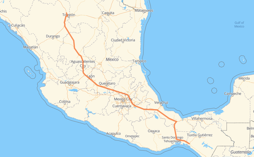
The distance from Arriaga to Lázaro Cárdenas is 1,838 kilometers by road including 1,120 kilometers on motorways. Road takes approximately 19 hours and 33 minutes and goes through Orizaba, Celaya, Salamanca, Aguascalientes and Fresnillo.
| Shortest distance by air | 1,463 km ✈️ |
| Car route length | 1,838 km 🚗 |
| Driving time | 19 h 33 min |
| Fuel amount | 147 L |
| Fuel cost | 217.6 GBP |
| Toll roads cost | 1,308 + ? MXN |
| Point | Distance | Time | Fuel | |
| Arriaga | 0 km | 00 min | 0.0 L | |
|
MEX 200 44 km, 28 min
|
||||
| San Pedro Tapanatepec | 44 km | 28 min | 3.2 L | |
|
MEX 200 MEX 190 24 km, 17 min
|
||||
| Santo Domingo Zanatepec | 67 km | 46 min | 5.0 L | |
|
MEX 190 46 km, 30 min
|
||||
| Santo Domingo Ingenio | 113 km | 1 h 16 min | 8.6 L | |
|
MEX 190 MEX 145D 456 km, 5 h 02 min
|
||||
| Orizaba | 569 km | 6 h 19 min | 45.2 L | |
|
MEX 150D 514 km, 5 h 24 min
|
||||
| Celaya | 1,084 km | 11 h 44 min | 86.6 L | |
|
MEX 45D 34 km, 20 min
|
||||
| Salamanca | 1,118 km | 12 h 04 min | 89.4 L | |
|
MEX 45D 208 km, 2 h 03 min
|
||||
| Aguascalientes | 1,326 km | 14 h 07 min | 105.7 L | |
|
MEX 45 MEX 45D 172 km, 1 h 53 min
|
||||
| Fresnillo | 1,498 km | 16 h 00 min | 119.0 L | |
|
MEX 45D MEX 49 344 km, 3 h 32 min
|
||||
| Lázaro Cárdenas | 1,842 km | 19 h 33 min | 147.3 L | |
Frequently Asked Questions
How many toll booths are there from Arriaga to Lázaro Cárdenas?
There are 23 toll booths between Arriaga and Lázaro Cárdenas: León Guzmán, Fortín, Cuitláhuac, Cosamaloapan, Acayucan, Cuencame, Morfín Chávez, Calera, Veta Grande, Zacatecas, Encarnacion De Diaz, León - Aguascalientes, Puerto Interior, Mendoza, Cerro Gordo, Apaseo el Grande, Queretaro, Palmillas, San Martin Texmelucan, San Martín, Amozoc 2, Amozoc and Esperanza 27.
How much does the toll booths cost from Arriaga to Lázaro Cárdenas?
Toll roads cost: Acayucan (?) + Cosamaloapan (229 MXN) + Cuitláhuac (114 MXN) + Fortín (33 MXN) + Esperanza 27 (140 MXN) + Amozoc (72 MXN) + Amozoc 2 (81 MXN) + San Martín (42 MXN) + San Martin Texmelucan (?) + Queretaro (?) + Palmillas (89 MXN) + Apaseo el Grande (?) + Cerro Gordo (?) + Mendoza (53 MXN) + Puerto Interior (?) + León - Aguascalientes (153 MXN) + Encarnacion De Diaz (150 MXN) + Zacatecas (41 MXN) + Veta Grande (48 MXN) + Calera (23 MXN) + Morfín Chávez (40 MXN) + Cuencame (?) + León Guzmán (?) = 1,308 + ? MXN
How much does it cost to drive from Arriaga to Lázaro Cárdenas?
Fuel cost: 217.6 GBP
This fuel cost is calculated as: (Route length 1,838 km / 100 km) * (Fuel consumption 8 L/100 km) * (Fuel price 1.48 GBP / L)
You can adjust fuel consumption and fuel price here.
Toll roads cost: 1,308 + ? MXN
How long is a car ride from Arriaga to Lázaro Cárdenas?
Driving time: 19 h 33 min
This time is calculated for driving at the maximum permitted speed, taking into account traffic rules restrictions.
- 88 km with a maximum speed 112 km/h = 47 min
- 387 km with a maximum speed 110 km/h = 3 h 31 min
- 463 km with a maximum speed 100 km/h = 4 h 37 min
- 376 km with a maximum speed 96 km/h = 3 h 55 min
- 65 km with a maximum speed 90 km/h = 43 min
- 406 km with a maximum speed 80 km/h = 5 h 4 min
- 37 km with a maximum speed 70 km/h = 32 min
- 12 km with a maximum speed 60 km/h = 12 min
- 2 km with a maximum speed 50 km/h = 1 min
- 3 km with a maximum speed 40 km/h = 5 min
- 2 km with a maximum speed 30 km/h = 3 min
The calculated driving time does not take into account intermediate stops and traffic jams.
How far is Arriaga to Lázaro Cárdenas by land?
The distance between Arriaga and Lázaro Cárdenas is 1,838 km by road including 1,120 km on motorways.
Precise satellite coordinates of highways were used for this calculation. The start and finish points are the centers of Arriaga and Lázaro Cárdenas respectively.
How far is Arriaga to Lázaro Cárdenas by plane?
The shortest distance (air line, as the crow flies) between Arriaga and Lázaro Cárdenas is 1,463 km.
This distance is calculated using the Haversine formula as a great-circle distance between two points on the surface of a sphere. The start and finish points are the centers of Arriaga and Lázaro Cárdenas respectively. Actual distance between airports may be different.
How many hours is Arriaga from Lázaro Cárdenas by plane?
Boeing 737 airliner needs 1 h 49 min to cover the distance of 1,463 km at a cruising speed of 800 km/h.
Small plane "Cessna 172" needs 6 h 39 min to flight this distance at average speed of 220 km/h.
This time is approximate and do not take into account takeoff and landing times, airport location and other real world factors.
How long is a helicopter ride from Arriaga to Lázaro Cárdenas?
Fast helicopter "Eurocopter AS350" or "Hughes OH-6 Cayuse" need 6 h 5 min to cover the distance of 1,463 km at a cruising speed of 240 km/h.
Popular "Robinson R44" needs 6 h 58 min to flight this distance at average speed of 210 km/h.
This time is approximate and do not take into account takeoff and landing times, aerodrome location and other real world factors.
What city is halfway between Arriaga and Lázaro Cárdenas?
The halfway point between Arriaga and Lázaro Cárdenas is Xochitlán de las Flores. It is located about 9 km from the exact midpoint by road.
The distance from Xochitlán de las Flores to Arriaga is 910 km and driving will take about 10 h 4 min. The road between Xochitlán de las Flores and Lázaro Cárdenas has length 928 km and will take approximately 9 h 29 min.
The other cities located close to halfway point:
Where is Arriaga in relation to Lázaro Cárdenas?
Arriaga is located 1,463 km south-east of Lázaro Cárdenas.
Arriaga has geographic coordinates: latitude 16.23527, longitude -93.89969.
Lázaro Cárdenas has geographic coordinates: latitude 25.80367, longitude -103.59034.
Which highway goes from Arriaga to Lázaro Cárdenas?
The route from Arriaga to Lázaro Cárdenas follows MEX 150D, MEX 45D, MEX 49, MEX 145D, MEX M40D, MEX 185, MEX 45.
Other minor sections pass along the road:
- MEX 40D: 89 km
- MEX 49D: 88 km
- MEX 47D: 84 km
- MEX 190: 80 km
- MEX 43D: 77 km
- MEX 57D: 56 km
- MEX 70: 50 km
- MEX 200: 47 km
- MEX 40: 9 km
- MEX 185D: 6 km
- MEX 140D: 2 km