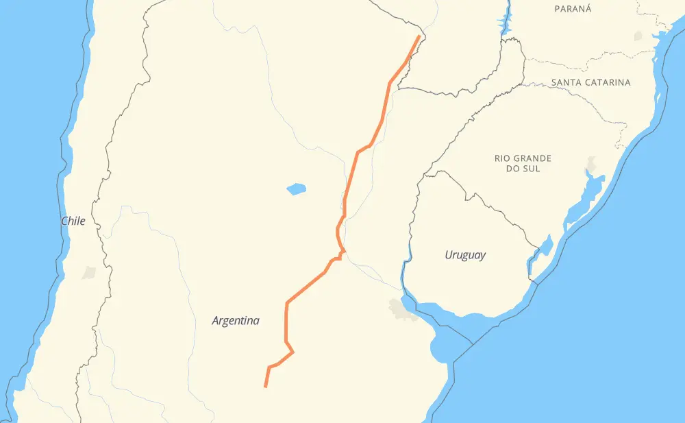
Distance between Atreucó and Riacho Negro
The distance from Atreucó to Riacho Negro is 1,619 kilometers by road including 161 kilometers on motorways. Road takes approximately 18 hours and 1 minute and goes through Resistencia, Formosa, Catriló, General Villegas, Colonia Dolores, Sancti Spíritu and Cumelén.
| Shortest distance by air | 1,421 km ✈️ |
| Car route length | 1,619 km 🚗 |
| Driving time | 18 h 1 min |
| Fuel amount | 129.5 L |
| Fuel cost | 191.7 GBP |
| Point | Distance | Time | Fuel | |
| Atreucó | 0 km | 00 min | 0.0 L | |
|
RP18 RP1 108 km, 1 h 09 min
|
||||
| Catriló | 108 km | 1 h 09 min | 8.3 L | |
|
RN5 RN33 205 km, 2 h 13 min
|
||||
| General Villegas | 313 km | 3 h 23 min | 23.6 L | |
|
RN33 80 km, 51 min
|
||||
| Colonia Dolores | 393 km | 4 h 14 min | 30.9 L | |
|
RN33 57 km, 37 min
|
||||
| Sancti Spíritu | 450 km | 4 h 51 min | 34.5 L | |
|
RN33 51 km, 35 min
|
||||
| Cumelén | 502 km | 5 h 26 min | 39.8 L | |
|
RN33 50 km, 35 min
|
||||
| Firmat | 551 km | 6 h 01 min | 43.9 L | |
|
RN33 RN11 793 km, 8 h 59 min
|
||||
| Resistencia | 1,344 km | 15 h 01 min | 106.7 L | |
|
RN11 177 km, 1 h 56 min
|
||||
| Formosa | 1,521 km | 16 h 57 min | 121.1 L | |
|
RN11 98 km, 1 h 03 min
|
||||
| Riacho Negro | 1,619 km | 18 h 00 min | 128.7 L | |
Frequently Asked Questions
How much does it cost to drive from Atreucó to Riacho Negro?
Fuel cost: 191.7 GBP
This fuel cost is calculated as: (Route length 1,619 km / 100 km) * (Fuel consumption 8 L/100 km) * (Fuel price 1.48 GBP / L)
You can adjust fuel consumption and fuel price here.
How long is a car ride from Atreucó to Riacho Negro?
Driving time: 18 h 1 min
This time is calculated for driving at the maximum permitted speed, taking into account traffic rules restrictions.
- 147 km with a maximum speed 112 km/h = 1 h 18 min
- 6 km with a maximum speed 110 km/h = 3 min
- 2 km with a maximum speed 100 km/h = 1 min
- 1,045 km with a maximum speed 96 km/h = 10 h 53 min
- 2 km with a maximum speed 90 km/h = 1 min
- 316 km with a maximum speed 80 km/h = 3 h 56 min
- 91 km with a maximum speed 60 km/h = 1 h 31 min
- 4 km with a maximum speed 50 km/h = 4 min
- 4 km with a maximum speed 40 km/h = 6 min
- 1 km with a maximum speed 20 km/h = 3 min
The calculated driving time does not take into account intermediate stops and traffic jams.
How far is Atreucó to Riacho Negro by land?
The distance between Atreucó and Riacho Negro is 1,619 km by road including 161 km on motorways.
Precise satellite coordinates of highways were used for this calculation. The start and finish points are the centers of Atreucó and Riacho Negro respectively.
How far is Atreucó to Riacho Negro by plane?
The shortest distance (air line, as the crow flies) between Atreucó and Riacho Negro is 1,421 km.
This distance is calculated using the Haversine formula as a great-circle distance between two points on the surface of a sphere. The start and finish points are the centers of Atreucó and Riacho Negro respectively. Actual distance between airports may be different.
How many hours is Atreucó from Riacho Negro by plane?
Boeing 737 airliner needs 1 h 46 min to cover the distance of 1,421 km at a cruising speed of 800 km/h.
Small plane "Cessna 172" needs 6 h 27 min to flight this distance at average speed of 220 km/h.
This time is approximate and do not take into account takeoff and landing times, airport location and other real world factors.
How long is a helicopter ride from Atreucó to Riacho Negro?
Fast helicopter "Eurocopter AS350" or "Hughes OH-6 Cayuse" need 5 h 55 min to cover the distance of 1,421 km at a cruising speed of 240 km/h.
Popular "Robinson R44" needs 6 h 46 min to flight this distance at average speed of 210 km/h.
This time is approximate and do not take into account takeoff and landing times, aerodrome location and other real world factors.
What city is halfway between Atreucó and Riacho Negro?
The halfway point between Atreucó and Riacho Negro is Gobernador Candioti. It is located about 35 km from the exact midpoint by road.
The distance from Gobernador Candioti to Atreucó is 844 km and driving will take about 9 h 6 min. The road between Gobernador Candioti and Riacho Negro has length 774 km and will take approximately 8 h 54 min.
The other cities located close to halfway point:
Where is Atreucó in relation to Riacho Negro?
Atreucó is located 1,421 km south-west of Riacho Negro.
Atreucó has geographic coordinates: latitude -37.12842, longitude -63.8147.
Riacho Negro has geographic coordinates: latitude -25.42322, longitude -57.79145.
Which highway goes from Atreucó to Riacho Negro?
The route from Atreucó to Riacho Negro follows RN11, RN33, AP01, RN5.
Other minor sections pass along the road:
- RP1: 70 km
- RNA012: 36 km
- RNA007: 24 km
- RP18: 13 km