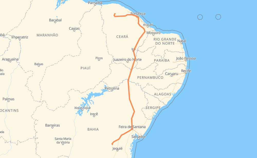
Distance between Bahia and Maracás
The distance from Bahia to Maracás is 1,561 kilometers by road including 119 kilometers on motorways. Road takes approximately 17 hours and 16 minutes and goes through Irauçuba, Itapajé, São Luís do Curu, Genipabú, Lagoa dos Porcos, Conjunto Palmeiras and Pedras.
| Shortest distance by air | 1,100 km ✈️ |
| Car route length | 1,561 km 🚗 |
| Driving time | 17 h 16 min |
| Fuel amount | 124.9 L |
| Fuel cost | 186.1 GBP |
| Point | Distance | Time | Fuel | |
| -3.55289, -40.24731 | 0 km | 00 min | 0.0 L | |
|
BR-222 102 km, 1 h 06 min
|
||||
| Irauçuba | 102 km | 1 h 06 min | 13.1 L | |
|
BR-222 22 km, 16 min
|
||||
| Itapajé | 124 km | 1 h 23 min | 16.3 L | |
|
BR-222 48 km, 31 min
|
||||
| São Luís do Curu | 173 km | 1 h 54 min | 19.7 L | |
|
BR-222 42 km, 27 min
|
||||
| Primavera | 215 km | 2 h 22 min | 23.6 L | |
|
BR-222 10 km, 07 min
|
||||
| Genipabú | 224 km | 2 h 29 min | 24.5 L | |
|
BR-222 5 km, 03 min
|
||||
| Lagoa dos Porcos | 229 km | 2 h 33 min | 24.5 L | |
|
BR-222 BR-020 23 km, 17 min
|
||||
| Conjunto Palmeiras | 252 km | 2 h 50 min | 26.8 L | |
|
BR-020 3 km, 02 min
|
||||
| Pedras | 256 km | 2 h 53 min | 26.8 L | |
|
BR-020 BR-116 295 km, 3 h 23 min
|
||||
| Aluisio Diógenes | 550 km | 6 h 17 min | 50.5 L | |
|
BR-116 689 km, 7 h 32 min
|
||||
| Teofilândia | 1,239 km | 13 h 49 min | 105.1 L | |
|
BR-116 327 km, 3 h 26 min
|
||||
| -13.44089, -40.43305 | 1,567 km | 17 h 16 min | 131.9 L | |
Frequently Asked Questions
How much does it cost to drive from Bahia to Maracás?
Fuel cost: 186.1 GBP
This fuel cost is calculated as: (Route length 1,561 km / 100 km) * (Fuel consumption 8 L/100 km) * (Fuel price 1.49 GBP / L)
You can adjust fuel consumption and fuel price here.
How long is a car ride from Bahia to Maracás?
Driving time: 17 h 16 min
This time is calculated for driving at the maximum permitted speed, taking into account traffic rules restrictions.
- 75 km with a maximum speed 110 km/h = 40 min
- 27 km with a maximum speed 100 km/h = 16 min
- 1,007 km with a maximum speed 96 km/h = 10 h 29 min
- 433 km with a maximum speed 80 km/h = 5 h 24 min
- 23 km with a maximum speed 60 km/h = 22 min
- 2 km with a maximum speed 40 km/h = 2 min
The calculated driving time does not take into account intermediate stops and traffic jams.
How far is Bahia to Maracás by land?
The distance between Bahia and Maracás is 1,561 km by road including 119 km on motorways.
Precise satellite coordinates of highways were used for this calculation. The start and finish points are the centers of Bahia and Maracás respectively.
How far is Bahia to Maracás by plane?
The shortest distance (air line, as the crow flies) between Bahia and Maracás is 1,100 km.
This distance is calculated using the Haversine formula as a great-circle distance between two points on the surface of a sphere. The start and finish points are the centers of Bahia and Maracás respectively. Actual distance between airports may be different.
How many hours is Bahia from Maracás by plane?
Boeing 737 airliner needs 1 h 22 min to cover the distance of 1,100 km at a cruising speed of 800 km/h.
Small plane "Cessna 172" needs 5 h to flight this distance at average speed of 220 km/h.
This time is approximate and do not take into account takeoff and landing times, airport location and other real world factors.
How long is a helicopter ride from Bahia to Maracás?
Fast helicopter "Eurocopter AS350" or "Hughes OH-6 Cayuse" need 4 h 35 min to cover the distance of 1,100 km at a cruising speed of 240 km/h.
Popular "Robinson R44" needs 5 h 14 min to flight this distance at average speed of 210 km/h.
This time is approximate and do not take into account takeoff and landing times, aerodrome location and other real world factors.
What city is halfway between Bahia and Maracás?
The halfway point between Bahia and Maracás is Antônio Conselheiro. It is located about 124 km from the exact midpoint by road.
The distance from Antônio Conselheiro to Bahia is 905 km and driving will take about 10 h 3 min. The road between Antônio Conselheiro and Maracás has length 656 km and will take approximately 7 h 13 min.
The other cities located close to halfway point:
Where is Bahia in relation to Maracás?
Bahia is located 1,100 km north of Maracás.
Bahia has geographic coordinates: latitude -3.55289, longitude -40.24731.
Maracás has geographic coordinates: latitude -13.44089, longitude -40.43305.
Which highway goes from Bahia to Maracás?
The route from Bahia to Maracás follows BR-116, BR-222.
Other minor sections pass along the road:
- BA-026: 90 km
- BR-020: 23 km
- BR-403: 23 km
- CE-178: 23 km
- CE-350: 18 km
- BR-230: 13 km
- CE-284: 11 km
- CE-251: 4 km