Distance between Barnabés and Amaral
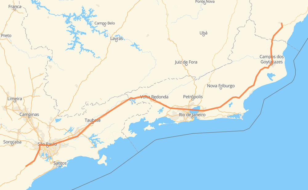
The distance from Barnabés to Amaral is 919 kilometers by road including 575 kilometers on motorways. Road takes approximately 10 hours and 20 minutes and goes through Taboão da Serra, Jacareí, Guaratinguetá and Magé.
| Shortest distance by air | 711 km ✈️ |
| Car route length | 919 km 🚗 |
| Driving time | 10 h 20 min |
| Fuel amount | 73.6 L |
| Fuel cost | 109.6 GBP |
| Point | Distance | Time | Fuel | |
| Barnabés | 0 km | 00 min | 0.0 L | |
|
SP-230 20 km, 11 min
|
||||
| Bairro do Soturno | 20 km | 11 min | 1.3 L | |
|
SP-230 36 km, 21 min
|
||||
| Taboão da Serra | 56 km | 32 min | 4.5 L | |
|
SP-230 SP-021 20 km, 13 min
|
||||
| Vila São José | 77 km | 46 min | 6.0 L | |
|
BR-374 SP-070 59 km, 35 min
|
||||
| Taboão | 136 km | 1 h 22 min | 10.7 L | |
|
SP-070 6 km, 03 min
|
||||
| Taboão | 141 km | 1 h 25 min | 10.9 L | |
|
SP-070 29 km, 17 min
|
||||
| Jacareí | 170 km | 1 h 42 min | 13.4 L | |
|
SP-070 SP-060 103 km, 1 h 00 min
|
||||
| Guaratinguetá | 274 km | 2 h 42 min | 21.7 L | |
|
SP-060 BR-116 271 km, 2 h 58 min
|
||||
| Magé | 545 km | 5 h 41 min | 43.1 L | |
|
BR-493 BR-101 375 km, 4 h 38 min
|
||||
| Amaral | 920 km | 10 h 20 min | 73.6 L | |
Frequently Asked Questions
How much does it cost to drive from Barnabés to Amaral?
Fuel cost: 109.6 GBP
This fuel cost is calculated as: (Route length 919 km / 100 km) * (Fuel consumption 8 L/100 km) * (Fuel price 1.49 GBP / L)
You can adjust fuel consumption and fuel price here.
How long is a car ride from Barnabés to Amaral?
Driving time: 10 h 20 min
This time is calculated for driving at the maximum permitted speed, taking into account traffic rules restrictions.
- 105 km with a maximum speed 112 km/h = 55 min
- 223 km with a maximum speed 110 km/h = 2 h 1 min
- 129 km with a maximum speed 100 km/h = 1 h 17 min
- 130 km with a maximum speed 96 km/h = 1 h 21 min
- 27 km with a maximum speed 90 km/h = 17 min
- 189 km with a maximum speed 80 km/h = 2 h 21 min
- 32 km with a maximum speed 70 km/h = 27 min
- 65 km with a maximum speed 60 km/h = 1 h 4 min
- 1 km with a maximum speed 50 km/h = 1 min
- 21 km with a maximum speed 40 km/h = 31 min
The calculated driving time does not take into account intermediate stops and traffic jams.
How far is Barnabés to Amaral by land?
The distance between Barnabés and Amaral is 919 km by road including 575 km on motorways.
Precise satellite coordinates of highways were used for this calculation. The start and finish points are the centers of Barnabés and Amaral respectively.
How far is Barnabés to Amaral by plane?
The shortest distance (air line, as the crow flies) between Barnabés and Amaral is 711 km.
This distance is calculated using the Haversine formula as a great-circle distance between two points on the surface of a sphere. The start and finish points are the centers of Barnabés and Amaral respectively. Actual distance between airports may be different.
How many hours is Barnabés from Amaral by plane?
Boeing 737 airliner needs 53 min to cover the distance of 711 km at a cruising speed of 800 km/h.
Small plane "Cessna 172" needs 3 h 13 min to flight this distance at average speed of 220 km/h.
This time is approximate and do not take into account takeoff and landing times, airport location and other real world factors.
How long is a helicopter ride from Barnabés to Amaral?
Fast helicopter "Eurocopter AS350" or "Hughes OH-6 Cayuse" need 2 h 57 min to cover the distance of 711 km at a cruising speed of 240 km/h.
Popular "Robinson R44" needs 3 h 23 min to flight this distance at average speed of 210 km/h.
This time is approximate and do not take into account takeoff and landing times, aerodrome location and other real world factors.
What city is halfway between Barnabés and Amaral?
The halfway point between Barnabés and Amaral is Varjão. It is located about 35 km from the exact midpoint by road.
The distance from Varjão to Barnabés is 425 km and driving will take about 4 h 17 min. The road between Varjão and Amaral has length 495 km and will take approximately 6 h 2 min.
The other cities located close to halfway point:
Where is Barnabés in relation to Amaral?
Barnabés is located 711 km south-west of Amaral.
Barnabés has geographic coordinates: latitude -23.98309, longitude -47.14427.
Amaral has geographic coordinates: latitude -20.85859, longitude -41.10745.
Which highway goes from Barnabés to Amaral?
The route from Barnabés to Amaral follows BR-101, BR-116, SP-060, SP-070.
Other minor sections pass along the road:
- BR-493: 71 km
- SP-230: 56 km
- SP-015: 22 km
- RJ-109: 19 km
- BR-459: 14 km
- SP-021: 13 km
- BR-383: 11 km
- BR-050: 7 km
- BR-482: 6 km
- BR-374: 4 km
- SP-280: 4 km
- SPI 117/070: 3 km
- KM-272: 3 km
- SPM-280 E: 2 km
- SPI-016/021: 2 km