Distance between Beattock and Frinton-on-Sea

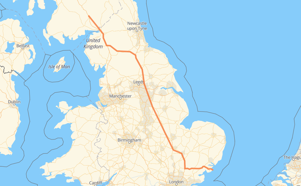
The distance from Beattock to Frinton-on-Sea is 600 kilometers by road including 267 kilometers on motorways. Road takes approximately 5 hours and 58 minutes and goes through Carlisle, Lockerbie, Gretna, Penrith, Appleby-in-Westmorland, Catterick and Wetherby.

Click here to load the interactive map
Compare this route in other services:
City
Town
Village
Hamlet
Motorway
Primary
Secondary
Unclassified
Point Distance Time Fuel
Beattock 0 km 0:00 00 min 0.0 L
A701 B7076 22 km, 13 min
Lockerbie 22 km 0:13 13 min 1.4 L
A74(M) 26 km, 13 min
Gretna 48 km 0:26 26 min 3.8 L
A74(M) M6 19 km, 10 min
Carlisle 67 km 0:36 36 min 5.2 L
M6 25 km, 13 min
Penrith 92 km 0:50 50 min 7.1 L
M6 A66 23 km, 14 min
Appleby-in-Westmorland 115 km 1:05 1 h 05 min 9.0 L
A66 67 km, 41 min
Catterick 182 km 1:46 1 h 46 min 14.4 L
A1(M) 54 km, 28 min
Wetherby 236 km 2:15 2 h 15 min 18.6 L
A1(M) 63 km, 34 min
Tickhill 298 km 2:50 2 h 50 min 23.6 L
A1(M) A1 302 km, 3 h 07 min
Frinton-on-Sea 600 km 5:58 5 h 58 min 47.9 L
City
Town
Village
Hamlet
Motorway
Primary
Secondary
Unclassified
Point Distance Time Fuel
Beattock 0 km 0:00 00 min 0.0 L
A701 B7076 9 km, 05 min
Johnstonebridge 9 km 0:05 05 min 0.1 L
B7076 A74(M) 13 km, 07 min
Lockerbie 22 km 0:12 12 min 1.4 L
A74(M) 10 km, 05 min
Ecclefechan 32 km 0:18 18 min 2.3 L
A74(M) 7 km, 03 min
Kirkpatrick Fleming 39 km 0:22 22 min 2.9 L
A74(M) 6 km, 02 min
Redhouse 45 km 0:25 25 min 3.4 L
A74(M) 3 km, 01 min
Gretna 48 km 0:26 26 min 3.8 L
A74(M) M6 4 km, 02 min
Blackford 52 km 0:29 29 min 4.1 L
M6 2 km, 01 min
Todhills 55 km 0:30 30 min 4.3 L
M6 6 km, 02 min
Harker 60 km 0:33 33 min 4.6 L
M6 5 km, 02 min
Scotby 65 km 0:36 36 min 5.2 L
M6 2 km, 00 min
Carlisle 67 km 0:36 36 min 5.2 L
M6 6 km, 03 min
Wreay 73 km 0:40 40 min 5.5 L
M6 9 km, 04 min
Calthwaite 81 km 0:44 44 min 6.4 L
M6 11 km, 05 min
Penrith 92 km 0:50 50 min 7.1 L
M6 A66 7 km, 03 min
Lightwater 99 km 0:54 54 min 7.8 L
A66 2 km, 01 min
Whinfell 101 km 0:55 55 min 8.0 L
A66 4 km, 02 min
Temple Sowerby 104 km 0:57 57 min 8.2 L
A66 4 km, 02 min
Kirkby Thore 108 km 1:00 1 h 00 min 8.5 L
A66 4 km, 02 min
Crackenthorpe 112 km 1:02 1 h 02 min 8.8 L
A66 4 km, 02 min
Appleby-in-Westmorland 115 km 1:04 1 h 04 min 9.0 L
A66 9 km, 05 min
Warcop 124 km 1:10 1 h 10 min 9.8 L
A66 4 km, 02 min
Church Brough 128 km 1:13 1 h 13 min 10.2 L
A66 21 km, 13 min
Bowes 149 km 1:26 1 h 26 min 11.8 L
A66 9 km, 05 min
Greta Bridge 158 km 1:32 1 h 32 min 12.6 L
A66 20 km, 12 min
Brompton upon Swale 179 km 1:44 1 h 44 min 14.2 L
A1(M) 3 km, 01 min
Catterick 182 km 1:46 1 h 46 min 14.4 L
A1(M) 37 km, 19 min
Minskip 219 km 2:06 2 h 06 min 17.4 L
A1(M) 17 km, 08 min
Wetherby 236 km 2:15 2 h 15 min 18.6 L
A1(M) 7 km, 03 min
Bramham 243 km 2:18 2 h 18 min 19.3 L
A1(M) 6 km, 02 min
Aberford 248 km 2:21 2 h 21 min 19.7 L
A1(M) 4 km, 01 min
Micklefield 252 km 2:23 2 h 23 min 20.0 L
A1(M) 17 km, 09 min
Darrington 269 km 2:32 2 h 32 min 21.4 L
A1 3 km, 02 min
Wentbridge 272 km 2:34 2 h 34 min 21.6 L
A1 6 km, 03 min
Skellow 278 km 2:38 2 h 38 min 22.0 L
A1 A1(M) 21 km, 11 min
Tickhill 298 km 2:49 2 h 49 min 23.6 L
A1(M) 6 km, 03 min
Blyth 304 km 2:52 2 h 52 min 24.1 L
A1(M) A1 8 km, 04 min
Ranby 312 km 2:57 2 h 57 min 24.7 L
A1 8 km, 05 min
Elkesley 320 km 3:02 3 h 02 min 25.5 L
A1 2 km, 01 min
West Drayton 323 km 3:04 3 h 04 min 25.8 L
A1 1 km, 00 min
Markham Moor 324 km 3:05 3 h 05 min 25.9 L
A1 3 km, 01 min
Tuxford 327 km 3:06 3 h 06 min 25.9 L
A1 6 km, 03 min
Sutton on Trent 332 km 3:10 3 h 10 min 26.3 L
A1 4 km, 02 min
Carlton on Trent 337 km 3:13 3 h 13 min 26.9 L
A1 2 km, 01 min
Cromwell 339 km 3:14 3 h 14 min 27.0 L
A1 8 km, 04 min
Newark on Trent 347 km 3:19 3 h 19 min 27.5 L
A1 11 km, 06 min
Long Bennington 358 km 3:26 3 h 26 min 28.5 L
A1 4 km, 02 min
Foston 362 km 3:28 3 h 28 min 28.8 L
A1 8 km, 04 min
Barrowby 370 km 3:33 3 h 33 min 29.4 L
A1 4 km, 02 min
Little Ponton 374 km 3:36 3 h 36 min 29.7 L
A1 3 km, 02 min
Great Ponton 377 km 3:38 3 h 38 min 30.0 L
A1 3 km, 01 min
Easton 380 km 3:40 3 h 40 min 30.3 L
A1 10 km, 06 min
Stretton 390 km 3:46 3 h 46 min 31.0 L
A1 8 km, 05 min
Tickencote 399 km 3:51 3 h 51 min 31.8 L
A1 2 km, 01 min
Toll Bar 400 km 3:52 3 h 52 min 32.0 L
A1 3 km, 01 min
Stamford 403 km 3:54 3 h 54 min 32.1 L
A1 5 km, 03 min
Wittering 409 km 3:57 3 h 57 min 32.5 L
A1 12 km, 07 min
Chesterton 420 km 4:05 4 h 05 min 33.5 L
A1 A1(M) 10 km, 05 min
Sawtry 430 km 4:10 4 h 10 min 34.1 L
A1(M) 10 km, 05 min
Alconbury 441 km 4:16 4 h 16 min 35.2 L
A1(M) A14 17 km, 10 min
Conington 458 km 4:26 4 h 26 min 36.3 L
A14 8 km, 04 min
Lolworth 466 km 4:31 4 h 31 min 37.2 L
A14 M11 12 km, 06 min
Grantchester 477 km 4:38 4 h 38 min 38.0 L
M11 4 km, 02 min
Hauxton 481 km 4:40 4 h 40 min 38.4 L
M11 9 km, 04 min
Ickleton 490 km 4:45 4 h 45 min 39.0 L
M11 13 km, 06 min
Newport 503 km 4:52 4 h 52 min 40.2 L
M11 4 km, 01 min
Ugley 506 km 4:53 4 h 53 min 40.2 L
M11 4 km, 02 min
Ugley Green 510 km 4:56 4 h 56 min 40.8 L
M11 5 km, 02 min
Tilekiln Green 516 km 4:59 4 h 59 min 41.2 L
A120 6 km, 03 min
Takeley 521 km 5:02 5 h 02 min 41.4 L
A120 6 km, 03 min
Great Dunmow 527 km 5:06 5 h 06 min 42.1 L
A120 14 km, 08 min
Braintree 541 km 5:14 5 h 14 min 43.0 L
A120 7 km, 04 min
Bradwell 548 km 5:19 5 h 19 min 43.7 L
A120 5 km, 03 min
Coggeshall 553 km 5:23 5 h 23 min 44.0 L
A120 8 km, 06 min
Copford 561 km 5:29 5 h 29 min 44.8 L
A12 16 km, 09 min
Great Bromley 577 km 5:38 5 h 38 min 45.8 L
A120 A133 12 km, 07 min
Weeley 589 km 5:46 5 h 46 min 47.0 L
B1033 3 km, 02 min
Thorpe-le-Soken 591 km 5:48 5 h 48 min 47.2 L
B1033 B1034 7 km, 05 min
Walton-on-the-Naze 598 km 5:54 5 h 54 min 47.9 L
2 km, 02 min
Frinton-on-Sea 600 km 5:56 5 h 56 min 47.9 L

Frequently Asked Questions

How much does it cost to drive from Beattock to Frinton-on-Sea?

Fuel cost: 71.6 GBP

This fuel cost is calculated as: (Route length 600 km / 100 km) * (Fuel consumption 8 L/100 km) * (Fuel price 1.49 GBP / L)

You can adjust fuel consumption and fuel price here.

How long is a car ride from Beattock to Frinton-on-Sea?

Driving time: 5 h 58 min

This time is calculated for driving at the maximum permitted speed, taking into account traffic rules restrictions.

  • 266 km with a maximum speed 112 km/h = 2 h 22 min
  • 310 km with a maximum speed 96 km/h = 3 h 13 min
  • 13 km with a maximum speed 80 km/h = 9 min
  • 7 km with a maximum speed 64 km/h = 6 min
  • 5 km with a maximum speed 48 km/h = 6 min

The calculated driving time does not take into account intermediate stops and traffic jams.

How far is Beattock to Frinton-on-Sea by land?

The distance between Beattock and Frinton-on-Sea is 600 km by road including 267 km on motorways.

Precise satellite coordinates of highways were used for this calculation. The start and finish points are the centers of Beattock and Frinton-on-Sea respectively.

How far is Beattock to Frinton-on-Sea by plane?

The shortest distance (air line, as the crow flies) between Beattock and Frinton-on-Sea is 495 km.

This distance is calculated using the Haversine formula as a great-circle distance between two points on the surface of a sphere. The start and finish points are the centers of Beattock and Frinton-on-Sea respectively. Actual distance between airports may be different.

How many hours is Beattock from Frinton-on-Sea by plane?

Boeing 737 airliner needs 37 min to cover the distance of 495 km at a cruising speed of 800 km/h.

Small plane "Cessna 172" needs 2 h 15 min to flight this distance at average speed of 220 km/h.

This time is approximate and do not take into account takeoff and landing times, airport location and other real world factors.

How long is a helicopter ride from Beattock to Frinton-on-Sea?

Fast helicopter "Eurocopter AS350" or "Hughes OH-6 Cayuse" need 2 h 3 min to cover the distance of 495 km at a cruising speed of 240 km/h.

Popular "Robinson R44" needs 2 h 21 min to flight this distance at average speed of 210 km/h.

This time is approximate and do not take into account takeoff and landing times, aerodrome location and other real world factors.

What city is halfway between Beattock and Frinton-on-Sea?

The halfway point between Beattock and Frinton-on-Sea is Tickhill. It is located about 2 km from the exact midpoint by road.

The distance from Tickhill to Beattock is 298 km and driving will take about 2 h 49 min. The road between Tickhill and Frinton-on-Sea has length 302 km and will take approximately 3 h 8 min.

The other cities located close to halfway point:

  • Blyth is in 304 km from Beattock and 296 km from Frinton-on-Sea
  • Ranby is in 312 km from Beattock and 288 km from Frinton-on-Sea
  • Elkesley is in 320 km from Beattock and 280 km from Frinton-on-Sea

Where is Beattock in relation to Frinton-on-Sea?

Beattock is located 495 km north-west of Frinton-on-Sea.

Beattock has geographic coordinates: latitude 55.30443, longitude -3.45162.

Frinton-on-Sea has geographic coordinates: latitude 51.82926, longitude 1.24623.

Which highway goes from Beattock to Frinton-on-Sea?

The route from Beattock to Frinton-on-Sea follows A1(M), A1.

Other minor sections pass along the road:

  • A66: 80 km
  • A120: 53 km
  • M6: 44 km
  • M11: 44 km
  • A74(M): 38 km
  • A14: 23 km
  • A12: 12 km
  • B7076: 9 km
  • A133: 6 km
  • B1033: 4 km
  • B1034: 3 km
Have any questions? Contact us!