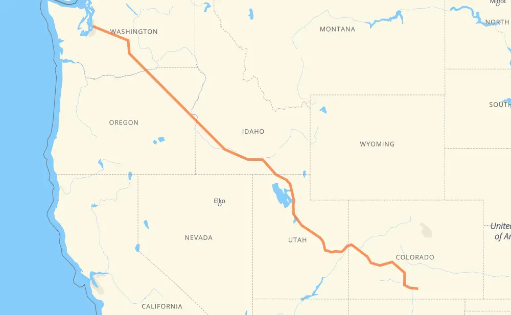
The distance from Burien to Fort Garland is 2,236 kilometers by road including 1,522 kilometers on motorways. Road takes approximately 22 hours and 23 minutes and goes through Bellevue, Yakima, Ogden, Salt Lake City, Provo, Grand Junction and Alamosa.
How much does it cost to drive from Burien to Fort Garland?
Fuel cost:
264.8 GBP
This fuel cost is calculated as: (Route length 2,236 km / 100 km) * (Fuel consumption 8 L/100 km) * (Fuel price 1.48 GBP / L)
You can adjust fuel consumption and fuel price here.
How long is a car ride from Burien to Fort Garland?
Driving time:
22 h 23 min
This time is calculated for driving at the maximum permitted speed, taking into account traffic rules restrictions.
1,062 km with a maximum speed 112 km/h = 9 h 29 min
111 km with a maximum speed 105 km/h = 1 h 3 min
181 km with a maximum speed 100 km/h = 1 h 48 min
57 km with a maximum speed 97 km/h = 35 min
378 km with a maximum speed 96 km/h = 3 h 55 min
202 km with a maximum speed 89 km/h = 2 h 16 min
28 km with a maximum speed 80 km/h = 20 min
149 km with a maximum speed 80 km/h = 1 h 51 min
49 km with a maximum speed 72 km/h = 40 min
3 km with a maximum speed 64 km/h = 2 min
11 km with a maximum speed 56 km/h = 11 min
2 km with a maximum speed 50 km/h = 2 min
2 km with a maximum speed 48 km/h = 1 min
The calculated driving time does not take into account intermediate stops and traffic jams.
How far is Burien to Fort Garland by land?
The distance between Burien and Fort Garland is 2,236 km by road including 1,522 km on motorways.
Precise satellite coordinates of highways were used for this calculation. The start and finish points are the centers of Burien and Fort Garland respectively.
How far is Burien to Fort Garland by plane?
The shortest distance (air line, as the crow flies) between Burien and Fort Garland is 1,775 km.
This distance is calculated using the Haversine formula as a great-circle distance between two points on the surface of a sphere. The start and finish points are the centers of Burien and Fort Garland respectively. Actual distance between airports may be different.
How many hours is Burien from Fort Garland by plane?
Boeing 737 airliner needs 2 h 13 min to cover the distance of 1,775 km at a cruising speed of 800 km/h.
Small plane "Cessna 172" needs 8 h 4 min to flight this distance at average speed of 220 km/h.
This time is approximate and do not take into account takeoff and landing times, airport location and other real world factors.
How long is a helicopter ride from Burien to Fort Garland?
Fast helicopter "Eurocopter AS350" or "Hughes OH-6 Cayuse" need 7 h 23 min to cover the distance of 1,775 km at a cruising speed of 240 km/h.
Popular "Robinson R44" needs 8 h 27 min to flight this distance at average speed of 210 km/h.
This time is approximate and do not take into account takeoff and landing times, aerodrome location and other real world factors.
What city is halfway between Burien and Fort Garland?
The halfway point between Burien and Fort Garland is Snowville. It is located about 61 km from the exact midpoint by road.
The distance from Snowville to Burien is 1,179 km and driving will take about 11 h 21 min. The road between Snowville and Fort Garland has length 1,057 km and will take approximately 11 h 2 min.
The other cities located close to halfway point:
Greenwood is in 1,035 km from Burien and 1,202 km from Fort Garland
Blue Creek is in 1,204 km from Burien and 1,033 km from Fort Garland
Tipperary Corner is in 1,012 km from Burien and 1,225 km from Fort Garland
Where is Burien in relation to Fort Garland?
Burien is located 1,775 km north-west of Fort Garland.
Burien has geographic coordinates: latitude 47.46992, longitude -122.34853.
Fort Garland has geographic coordinates: latitude 37.42895, longitude -105.43277.
Which highway goes from Burien to Fort Garland?
The route from Burien to Fort Garland follows I 84, US 30, US 6, US 50, I 15, I 90, I 70, US 191, I 82, US 26.