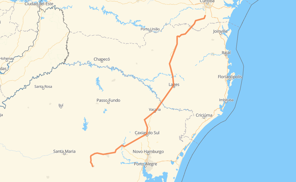
Distance between Cachoeira do Sul and Mandirituba
The distance from Cachoeira do Sul to Mandirituba is 783 kilometers by road. Road takes approximately 8 hours and 59 minutes and goes through Rincão Comprido, Germânia, Bem Feita, Grão Pará, São Rafael, Floresta and Imigrantes.
| Shortest distance by air | 590 km ✈️ |
| Car route length | 783 km 🚗 |
| Driving time | 8 h 59 min |
| Fuel amount | 62.6 L |
| Fuel cost | 93.3 GBP |
| Point | Distance | Time | Fuel | |
| -30.04808, -52.89015 | 0 km | 00 min | 0.0 L | |
|
BR-153 58 km, 37 min
|
||||
| Rincão Comprido | 58 km | 37 min | 9.3 L | |
|
RSC-153 RSC-287 35 km, 22 min
|
||||
| Germânia | 93 km | 59 min | 12.0 L | |
|
RSC-287 24 km, 16 min
|
||||
| Bem Feita | 117 km | 1 h 15 min | 13.8 L | |
|
RSC-287 RSC-453 9 km, 06 min
|
||||
| Grão Pará | 126 km | 1 h 22 min | 14.5 L | |
|
RSC-453 17 km, 11 min
|
||||
| São Rafael | 143 km | 1 h 33 min | 15.8 L | |
|
RSC-453 4 km, 03 min
|
||||
| Floresta | 147 km | 1 h 36 min | 16.3 L | |
|
RSC-453 61 km, 42 min
|
||||
| Imigrantes | 208 km | 2 h 19 min | 20.9 L | |
|
RSC-453 VRS-313 27 km, 25 min
|
||||
| Medianeira | 235 km | 2 h 44 min | 23.4 L | |
|
RSC-453 9 km, 08 min
|
||||
| Samuara | 244 km | 2 h 52 min | 23.9 L | |
|
RSC-453 14 km, 09 min
|
||||
| Linha 40 | 258 km | 3 h 02 min | 25.2 L | |
|
ERS-122 BR-116 525 km, 5 h 57 min
|
||||
| -25.77686, -49.32818 | 783 km | 8 h 59 min | 67.3 L | |
Frequently Asked Questions
How much does it cost to drive from Cachoeira do Sul to Mandirituba?
Fuel cost: 93.3 GBP
This fuel cost is calculated as: (Route length 783 km / 100 km) * (Fuel consumption 8 L/100 km) * (Fuel price 1.49 GBP / L)
You can adjust fuel consumption and fuel price here.
How long is a car ride from Cachoeira do Sul to Mandirituba?
Driving time: 8 h 59 min
This time is calculated for driving at the maximum permitted speed, taking into account traffic rules restrictions.
- 492 km with a maximum speed 96 km/h = 5 h 7 min
- 250 km with a maximum speed 80 km/h = 3 h 7 min
- 32 km with a maximum speed 60 km/h = 32 min
- 1 km with a maximum speed 50 km/h = 1 min
- 6 km with a maximum speed 40 km/h = 9 min
The calculated driving time does not take into account intermediate stops and traffic jams.
How far is Cachoeira do Sul to Mandirituba by land?
The distance between Cachoeira do Sul and Mandirituba is 783 km by road.
Precise satellite coordinates of highways were used for this calculation. The start and finish points are the centers of Cachoeira do Sul and Mandirituba respectively.
How far is Cachoeira do Sul to Mandirituba by plane?
The shortest distance (air line, as the crow flies) between Cachoeira do Sul and Mandirituba is 590 km.
This distance is calculated using the Haversine formula as a great-circle distance between two points on the surface of a sphere. The start and finish points are the centers of Cachoeira do Sul and Mandirituba respectively. Actual distance between airports may be different.
How many hours is Cachoeira do Sul from Mandirituba by plane?
Boeing 737 airliner needs 44 min to cover the distance of 590 km at a cruising speed of 800 km/h.
Small plane "Cessna 172" needs 2 h 40 min to flight this distance at average speed of 220 km/h.
This time is approximate and do not take into account takeoff and landing times, airport location and other real world factors.
How long is a helicopter ride from Cachoeira do Sul to Mandirituba?
Fast helicopter "Eurocopter AS350" or "Hughes OH-6 Cayuse" need 2 h 27 min to cover the distance of 590 km at a cruising speed of 240 km/h.
Popular "Robinson R44" needs 2 h 48 min to flight this distance at average speed of 210 km/h.
This time is approximate and do not take into account takeoff and landing times, aerodrome location and other real world factors.
What city is halfway between Cachoeira do Sul and Mandirituba?
The halfway point between Cachoeira do Sul and Mandirituba is Distrito Industrial II. It is located about 15 km from the exact midpoint by road.
The distance from Distrito Industrial II to Cachoeira do Sul is 376 km and driving will take about 4 h 20 min. The road between Distrito Industrial II and Mandirituba has length 407 km and will take approximately 4 h 38 min.
The other cities located close to halfway point:
Where is Cachoeira do Sul in relation to Mandirituba?
Cachoeira do Sul is located 590 km south-west of Mandirituba.
Cachoeira do Sul has geographic coordinates: latitude -30.04808, longitude -52.89015.
Mandirituba has geographic coordinates: latitude -25.77686, longitude -49.32818.
Which highway goes from Cachoeira do Sul to Mandirituba?
The route from Cachoeira do Sul to Mandirituba follows BR-116, RSC-453.
Other minor sections pass along the road:
- ERS-122: 89 km
- RSC-287: 80 km
- RSC-153: 42 km
- BR-153: 34 km
- VRS-313: 15 km
- BR-477: 6 km
- BR-386: 5 km
- ERS-437: 3 km
- ERS-130: 2 km