Distance between Campos Altos and São Fidélis
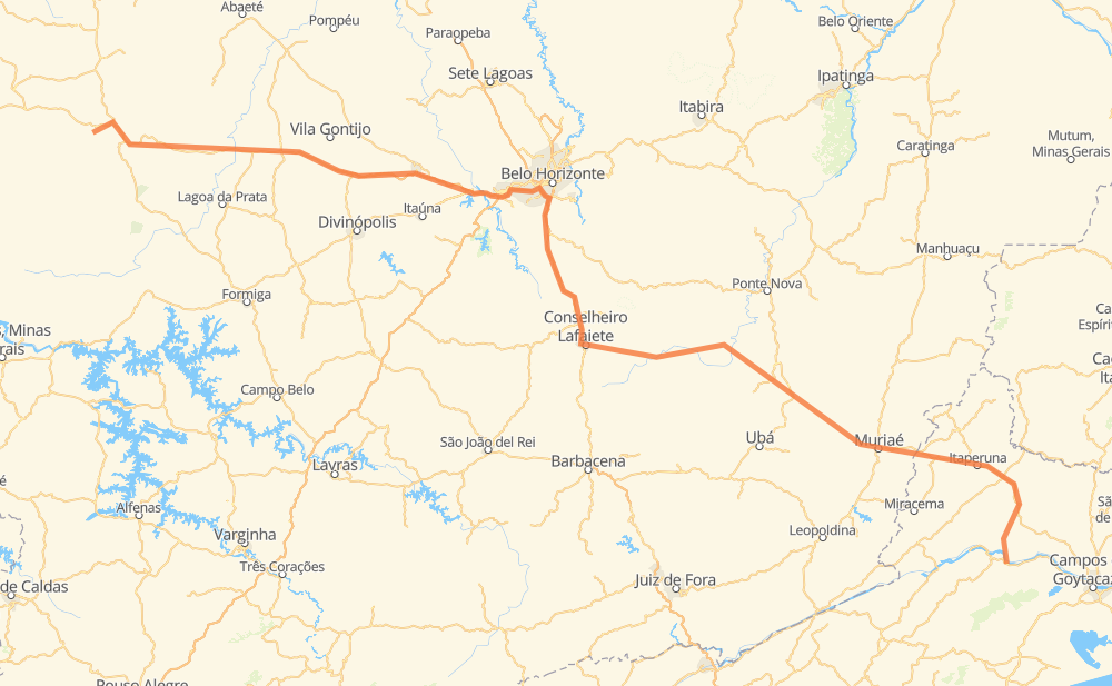
The distance from Campos Altos to São Fidélis is 708 kilometers by road including 141 kilometers on motorways. Road takes approximately 8 hours and 29 minutes and goes through Betim, Conselheiro Lafaiete, Muriaé, Luz, Nova Serrana, Pará de Minas and PTB.
| Shortest distance by air | 509 km ✈️ |
| Car route length | 708 km 🚗 |
| Driving time | 8 h 29 min |
| Fuel amount | 56.7 L |
| Fuel cost | 84.4 GBP |
| Point | Distance | Time | Fuel | |
| Campos Altos | 0 km | 00 min | 0.0 L | |
|
AMG-0720 BR-262 64 km, 46 min
|
||||
| Luz | 64 km | 46 min | 4.3 L | |
|
BR-262 88 km, 1 h 08 min
|
||||
| Nova Serrana | 152 km | 1 h 55 min | 11.7 L | |
|
BR-262 42 km, 23 min
|
||||
| Pará de Minas | 194 km | 2 h 18 min | 15.2 L | |
|
BR-262 47 km, 29 min
|
||||
| Betim | 241 km | 2 h 47 min | 18.8 L | |
|
BR-262 8 km, 04 min
|
||||
| PTB | 249 km | 2 h 52 min | 19.8 L | |
|
BR-381 BR-040 35 km, 24 min
|
||||
| Vale do Sol | 284 km | 3 h 17 min | 22.4 L | |
|
BR-040 8 km, 05 min
|
||||
| Alphaville | 291 km | 3 h 22 min | 23.0 L | |
|
BR-040 75 km, 53 min
|
||||
| Conselheiro Lafaiete | 367 km | 4 h 15 min | 28.0 L | |
|
BR-482 208 km, 2 h 36 min
|
||||
| Muriaé | 574 km | 6 h 51 min | 44.4 L | |
|
BR-356 136 km, 1 h 37 min
|
||||
| -21.64821, -41.74805 | 710 km | 8 h 29 min | 56.8 L | |
Frequently Asked Questions
How much does it cost to drive from Campos Altos to São Fidélis?
Fuel cost: 84.4 GBP
This fuel cost is calculated as: (Route length 708 km / 100 km) * (Fuel consumption 8 L/100 km) * (Fuel price 1.49 GBP / L)
You can adjust fuel consumption and fuel price here.
How long is a car ride from Campos Altos to São Fidélis?
Driving time: 8 h 29 min
This time is calculated for driving at the maximum permitted speed, taking into account traffic rules restrictions.
- 95 km with a maximum speed 110 km/h = 51 min
- 16 km with a maximum speed 100 km/h = 9 min
- 183 km with a maximum speed 96 km/h = 1 h 54 min
- 347 km with a maximum speed 80 km/h = 4 h 20 min
- 9 km with a maximum speed 70 km/h = 7 min
- 51 km with a maximum speed 60 km/h = 51 min
- 2 km with a maximum speed 50 km/h = 2 min
- 3 km with a maximum speed 40 km/h = 5 min
- 3 km with a maximum speed 30 km/h = 6 min
The calculated driving time does not take into account intermediate stops and traffic jams.
How far is Campos Altos to São Fidélis by land?
The distance between Campos Altos and São Fidélis is 708 km by road including 141 km on motorways.
Precise satellite coordinates of highways were used for this calculation. The start and finish points are the centers of Campos Altos and São Fidélis respectively.
How far is Campos Altos to São Fidélis by plane?
The shortest distance (air line, as the crow flies) between Campos Altos and São Fidélis is 509 km.
This distance is calculated using the Haversine formula as a great-circle distance between two points on the surface of a sphere. The start and finish points are the centers of Campos Altos and São Fidélis respectively. Actual distance between airports may be different.
How many hours is Campos Altos from São Fidélis by plane?
Boeing 737 airliner needs 38 min to cover the distance of 509 km at a cruising speed of 800 km/h.
Small plane "Cessna 172" needs 2 h 18 min to flight this distance at average speed of 220 km/h.
This time is approximate and do not take into account takeoff and landing times, airport location and other real world factors.
How long is a helicopter ride from Campos Altos to São Fidélis?
Fast helicopter "Eurocopter AS350" or "Hughes OH-6 Cayuse" need 2 h 7 min to cover the distance of 509 km at a cruising speed of 240 km/h.
Popular "Robinson R44" needs 2 h 25 min to flight this distance at average speed of 210 km/h.
This time is approximate and do not take into account takeoff and landing times, aerodrome location and other real world factors.
What city is halfway between Campos Altos and São Fidélis?
The halfway point between Campos Altos and São Fidélis is Conselheiro Lafaiete. It is located about 13 km from the exact midpoint by road.
The distance from Conselheiro Lafaiete to Campos Altos is 367 km and driving will take about 4 h 15 min. The road between Conselheiro Lafaiete and São Fidélis has length 341 km and will take approximately 4 h 13 min.
The other cities located close to halfway point:
Where is Campos Altos in relation to São Fidélis?
Campos Altos is located 509 km north-west of São Fidélis.
Campos Altos has geographic coordinates: latitude -19.69639, longitude -46.17139.
São Fidélis has geographic coordinates: latitude -21.64821, longitude -41.74805.
Which highway goes from Campos Altos to São Fidélis?
The route from Campos Altos to São Fidélis follows BR-262, BR-356, BR-482, MGC-482.
Other minor sections pass along the road:
- BR-040: 92 km
- MGC-356: 28 km
- BR-381: 23 km
- MGT-356: 16 km
- BR-120: 15 km
- BR-354: 12 km
- RJ-194: 7 km
- AMG-0720: 2 km
- RJ-206: 2 km