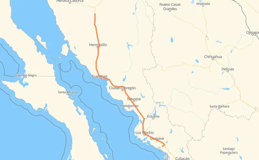
The distance from Casa Blanca to Nacozari is 749 kilometers by road including 631 kilometers on motorways. Road takes approximately 8 hours and 18 minutes and goes through Hermosillo, Navojoa, Los Mochis and Gabriel Leyva Solano.
How much does it cost to drive from Casa Blanca to Nacozari?
Fuel cost:
89.3 GBP
This fuel cost is calculated as: (Route length 749 km / 100 km) * (Fuel consumption 8 L/100 km) * (Fuel price 1.49 GBP / L)
You can adjust fuel consumption and fuel price here.
Toll roads cost:
401 + ? MXN
How long is a car ride from Casa Blanca to Nacozari?
Driving time:
8 h 18 min
This time is calculated for driving at the maximum permitted speed, taking into account traffic rules restrictions.
252 km with a maximum speed 110 km/h = 2 h 17 min
96 km with a maximum speed 100 km/h = 57 min
17 km with a maximum speed 96 km/h = 10 min
72 km with a maximum speed 90 km/h = 47 min
295 km with a maximum speed 80 km/h = 3 h 40 min
13 km with a maximum speed 60 km/h = 12 min
5 km with a maximum speed 50 km/h = 5 min
1 km with a maximum speed 10 km/h = 6 min
The calculated driving time does not take into account intermediate stops and traffic jams.
How far is Casa Blanca to Nacozari by land?
The distance between Casa Blanca and Nacozari is 749 km by road including 631 km on motorways.
Precise satellite coordinates of highways were used for this calculation. The start and finish points are the centers of Casa Blanca and Nacozari respectively.
How far is Casa Blanca to Nacozari by plane?
The shortest distance (air line, as the crow flies) between Casa Blanca and Nacozari is 621 km.
This distance is calculated using the Haversine formula as a great-circle distance between two points on the surface of a sphere. The start and finish points are the centers of Casa Blanca and Nacozari respectively. Actual distance between airports may be different.
How many hours is Casa Blanca from Nacozari by plane?
Boeing 737 airliner needs 46 min to cover the distance of 621 km at a cruising speed of 800 km/h.
Small plane "Cessna 172" needs 2 h 49 min to flight this distance at average speed of 220 km/h.
This time is approximate and do not take into account takeoff and landing times, airport location and other real world factors.
How long is a helicopter ride from Casa Blanca to Nacozari?
Fast helicopter "Eurocopter AS350" or "Hughes OH-6 Cayuse" need 2 h 35 min to cover the distance of 621 km at a cruising speed of 240 km/h.
Popular "Robinson R44" needs 2 h 57 min to flight this distance at average speed of 210 km/h.
This time is approximate and do not take into account takeoff and landing times, aerodrome location and other real world factors.
What city is halfway between Casa Blanca and Nacozari?
The halfway point between Casa Blanca and Nacozari is Jori.
The distance from Jori to Casa Blanca is 374 km and driving will take about 3 h 50 min. The road between Jori and Nacozari has length 375 km and will take approximately 4 h 27 min.
The other cities located close to halfway point:
Rancho el alamo is in 375 km from Casa Blanca and 374 km from Nacozari
La Miseria (El Choyal) is in 369 km from Casa Blanca and 380 km from Nacozari
Rancho Penjamo is in 382 km from Casa Blanca and 366 km from Nacozari
Where is Casa Blanca in relation to Nacozari?
Casa Blanca is located 621 km north-west of Nacozari.
Casa Blanca has geographic coordinates: latitude 30.32333, longitude -111.09183.
Nacozari has geographic coordinates: latitude 25.33658, longitude -108.25737.
Which highway goes from Casa Blanca to Nacozari?
The route from Casa Blanca to Nacozari follows MEX 15D.