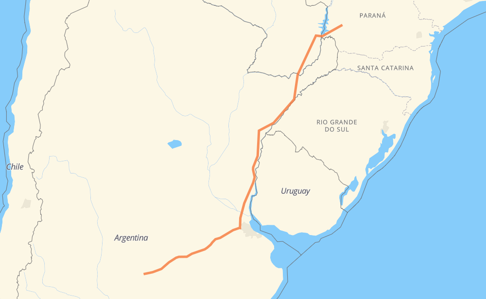
Distance between Cascavel and Santa Rosa
The distance from Cascavel to Santa Rosa is 1,942 kilometers by road including 45 kilometers on motorways. Road takes approximately 21 hours and 56 minutes and goes through Ciudad del Este, Minga Guazú, Encarnacion, Posadas, Alvear and Zárate.
| Shortest distance by air | 1,657 km ✈️ |
| Car route length | 1,942 km 🚗 |
| Driving time | 21 h 56 min |
| Fuel amount | 155.4 L |
| Fuel cost | 231.5 GBP |
| Point | Distance | Time | Fuel | |
| Cascavel | 0 km | 00 min | 0.0 L | |
|
BR-277 41 km, 29 min
|
||||
| Boa Vista | 41 km | 29 min | 2.7 L | |
|
BR-277 19 km, 15 min
|
||||
| Agro-Cafeeira | 60 km | 44 min | 4.3 L | |
|
BR-277 88 km, 1 h 04 min
|
||||
| Ciudad del Este | 148 km | 1 h 48 min | 11.3 L | |
|
PY02 23 km, 18 min
|
||||
| Minga Guazú | 171 km | 2 h 07 min | 12.4 L | |
|
PY02 PY06 252 km, 3 h 06 min
|
||||
| Encarnacion | 423 km | 5 h 13 min | 33.6 L | |
|
PY01 RN105 9 km, 07 min
|
||||
| Posadas | 432 km | 5 h 21 min | 34.4 L | |
|
RN105 RN14 235 km, 2 h 52 min
|
||||
| Alvear | 667 km | 8 h 13 min | 53.1 L | |
|
RN14 662 km, 6 h 58 min
|
||||
| Zárate | 1,329 km | 15 h 11 min | 105.2 L | |
|
RN12 RN5 616 km, 6 h 44 min
|
||||
| Santa Rosa | 1,945 km | 21 h 56 min | 153.3 L | |
Hotels of Santa Rosa
Frequently Asked Questions
How much does it cost to drive from Cascavel to Santa Rosa?
Fuel cost: 231.5 GBP
This fuel cost is calculated as: (Route length 1,942 km / 100 km) * (Fuel consumption 8 L/100 km) * (Fuel price 1.49 GBP / L)
You can adjust fuel consumption and fuel price here.
How long is a car ride from Cascavel to Santa Rosa?
Driving time: 21 h 56 min
This time is calculated for driving at the maximum permitted speed, taking into account traffic rules restrictions.
- 15 km with a maximum speed 112 km/h = 8 min
- 8 km with a maximum speed 110 km/h = 4 min
- 7 km with a maximum speed 100 km/h = 3 min
- 1,405 km with a maximum speed 96 km/h = 14 h 37 min
- 415 km with a maximum speed 80 km/h = 5 h 11 min
- 67 km with a maximum speed 60 km/h = 1 h 7 min
- 2 km with a maximum speed 50 km/h = 2 min
- 24 km with a maximum speed 40 km/h = 35 min
- 1 km with a maximum speed 30 km/h = 1 min
- 1 km with a maximum speed 20 km/h = 4 min
The calculated driving time does not take into account intermediate stops and traffic jams.
How far is Cascavel to Santa Rosa by land?
The distance between Cascavel and Santa Rosa is 1,942 km by road including 45 km on motorways.
Precise satellite coordinates of highways were used for this calculation. The start and finish points are the centers of Cascavel and Santa Rosa respectively.
How far is Cascavel to Santa Rosa by plane?
The shortest distance (air line, as the crow flies) between Cascavel and Santa Rosa is 1,657 km.
This distance is calculated using the Haversine formula as a great-circle distance between two points on the surface of a sphere. The start and finish points are the centers of Cascavel and Santa Rosa respectively. Actual distance between airports may be different.
How many hours is Cascavel from Santa Rosa by plane?
Boeing 737 airliner needs 2 h 4 min to cover the distance of 1,657 km at a cruising speed of 800 km/h.
Small plane "Cessna 172" needs 7 h 31 min to flight this distance at average speed of 220 km/h.
This time is approximate and do not take into account takeoff and landing times, airport location and other real world factors.
How long is a helicopter ride from Cascavel to Santa Rosa?
Fast helicopter "Eurocopter AS350" or "Hughes OH-6 Cayuse" need 6 h 54 min to cover the distance of 1,657 km at a cruising speed of 240 km/h.
Popular "Robinson R44" needs 7 h 53 min to flight this distance at average speed of 210 km/h.
This time is approximate and do not take into account takeoff and landing times, aerodrome location and other real world factors.
What city is halfway between Cascavel and Santa Rosa?
The halfway point between Cascavel and Santa Rosa is Ubajay. It is located about 88 km from the exact midpoint by road.
The distance from Ubajay to Cascavel is 1,059 km and driving will take about 12 h 19 min. The road between Ubajay and Santa Rosa has length 883 km and will take approximately 9 h 36 min.
The other cities located close to halfway point:
Where is Cascavel in relation to Santa Rosa?
Cascavel is located 1,657 km north-east of Santa Rosa.
Cascavel has geographic coordinates: latitude -24.9555, longitude -53.45605.
Santa Rosa has geographic coordinates: latitude -36.62039, longitude -64.29061.
Which highway goes from Cascavel to Santa Rosa?
The route from Cascavel to Santa Rosa follows RN14, RN5, PY06, BR-277.
Other minor sections pass along the road:
- RN12: 77 km
- RP6: 55 km
- RN105: 48 km
- PY02: 30 km
- PY01: 6 km
- PY18: 1 km
- RN7: 1 km