Distance between Cerro Bola and Juan José Ríos
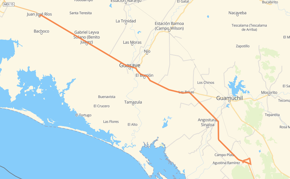
The distance from Cerro Bola to Juan José Ríos is 114 kilometers by road including 104 kilometers on motorways. Road takes approximately 1 hour and 20 minutes and goes through Gabriel Leyva Solano, Callejones de Guasavito, Adolfo Ruiz Cortines, Gabriel Leyva Velázquez (La Escalera), Las Brisas, El Burrion and Cinco de Mayo (Agua Blanca).
| Shortest distance by air | 99 km ✈️ |
| Car route length | 114 km 🚗 |
| Driving time | 1 h 20 min |
| Fuel amount | 9.1 L |
| Fuel cost | 13.7 GBP |
| Toll roads cost | 100 MXN |
| Point | Distance | Time | Fuel | |
| Cerro Bola | 0 km | 00 min | 0.0 L | |
|
MEX 15D 41 km, 27 min
|
||||
| Gabriel Leyva Velázquez (La Escalera) | 41 km | 27 min | 3.1 L | |
|
MEX 15D 8 km, 05 min
|
||||
| Las Brisas | 49 km | 33 min | 3.7 L | |
|
MEX 15D 14 km, 09 min
|
||||
| El Burrion | 63 km | 42 min | 4.6 L | |
|
MEX 15D 7 km, 05 min
|
||||
| Callejones de Guasavito | 70 km | 47 min | 5.4 L | |
|
MEX 15D 16 km, 12 min
|
||||
| Gabriel Leyva Solano | 86 km | 59 min | 5.9 L | |
|
MEX 15D 15 km, 11 min
|
||||
| Adolfo Ruiz Cortines | 101 km | 1 h 10 min | 7.8 L | |
|
MEX 15D 7 km, 05 min
|
||||
| Guayparime | 108 km | 1 h 15 min | 8.6 L | |
|
MEX 15D 6 km, 04 min
|
||||
| Juan José Ríos | 114 km | 1 h 20 min | 8.7 L | |
Frequently Asked Questions
How many toll booths are there from Cerro Bola to Juan José Ríos?
There are 2 toll booths between Cerro Bola and Juan José Ríos: Sinaloa and Las Brisas.
How much does the toll booths cost from Cerro Bola to Juan José Ríos?
Toll roads cost: Las Brisas (76 MXN) + Sinaloa (24 MXN) = 100 MXN
How much does it cost to drive from Cerro Bola to Juan José Ríos?
Fuel cost: 13.7 GBP
This fuel cost is calculated as: (Route length 114 km / 100 km) * (Fuel consumption 8 L/100 km) * (Fuel price 1.5 GBP / L)
You can adjust fuel consumption and fuel price here.
Toll roads cost: 100 MXN
How long is a car ride from Cerro Bola to Juan José Ríos?
Driving time: 1 h 20 min
This time is calculated for driving at the maximum permitted speed, taking into account traffic rules restrictions.
- 38 km with a maximum speed 100 km/h = 22 min
- 2 km with a maximum speed 96 km/h = 1 min
- 72 km with a maximum speed 80 km/h = 53 min
- 2 km with a maximum speed 50 km/h = 2 min
The calculated driving time does not take into account intermediate stops and traffic jams.
How far is Cerro Bola to Juan José Ríos by land?
The distance between Cerro Bola and Juan José Ríos is 114 km by road including 104 km on motorways.
Precise satellite coordinates of highways were used for this calculation. The start and finish points are the centers of Cerro Bola and Juan José Ríos respectively.
How far is Cerro Bola to Juan José Ríos by plane?
The shortest distance (air line, as the crow flies) between Cerro Bola and Juan José Ríos is 99 km.
This distance is calculated using the Haversine formula as a great-circle distance between two points on the surface of a sphere. The start and finish points are the centers of Cerro Bola and Juan José Ríos respectively. Actual distance between airports may be different.
How many hours is Cerro Bola from Juan José Ríos by plane?
Boeing 737 airliner needs 7 min to cover the distance of 99 km at a cruising speed of 800 km/h.
Small plane "Cessna 172" needs 27 min to flight this distance at average speed of 220 km/h.
This time is approximate and do not take into account takeoff and landing times, airport location and other real world factors.
How long is a helicopter ride from Cerro Bola to Juan José Ríos?
Fast helicopter "Eurocopter AS350" or "Hughes OH-6 Cayuse" need 24 min to cover the distance of 99 km at a cruising speed of 240 km/h.
Popular "Robinson R44" needs 28 min to flight this distance at average speed of 210 km/h.
This time is approximate and do not take into account takeoff and landing times, aerodrome location and other real world factors.
What city is halfway between Cerro Bola and Juan José Ríos?
The halfway point between Cerro Bola and Juan José Ríos is El Burrion. It is located about 6 km from the exact midpoint by road.
The distance from El Burrion to Cerro Bola is 63 km and driving will take about 42 min. The road between El Burrion and Juan José Ríos has length 51 km and will take approximately 38 min.
The other cities located close to halfway point:
Where is Cerro Bola in relation to Juan José Ríos?
Cerro Bola is located 99 km south-east of Juan José Ríos.
Cerro Bola has geographic coordinates: latitude 25.23825, longitude -108.02411.
Juan José Ríos has geographic coordinates: latitude 25.75751, longitude -108.82209.
Which highway goes from Cerro Bola to Juan José Ríos?
The route from Cerro Bola to Juan José Ríos follows MEX 15D.