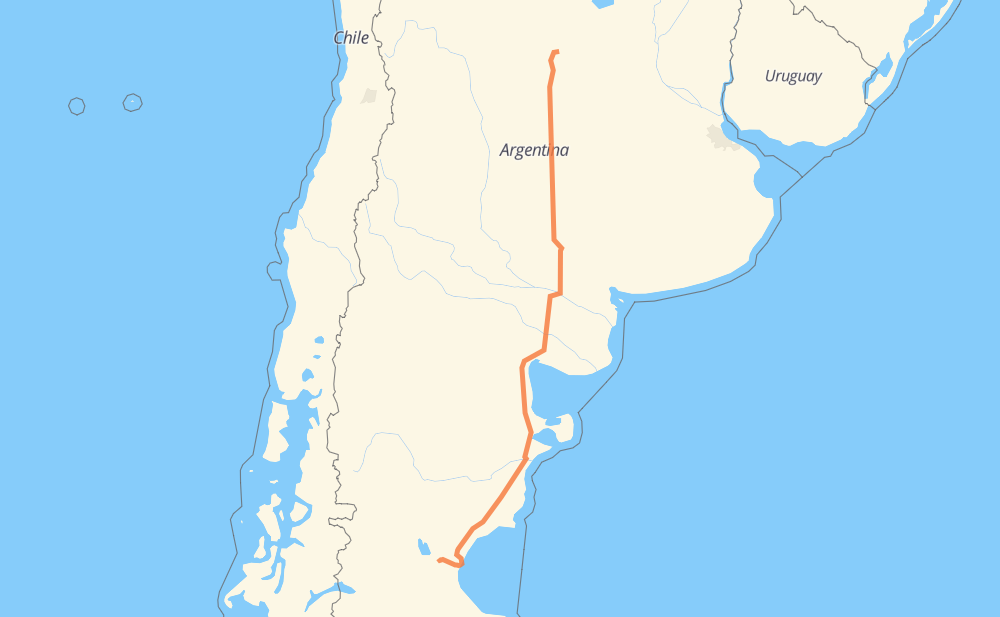
Distance between Cerro Dragón and Río Tercero
The distance from Cerro Dragón to Río Tercero is 1,808 kilometers by road. Road takes approximately 19 hours and 33 minutes and goes through Comodoro Rivadavia, Santa Rosa, Río Cuarto, Valle Hermoso, Pampa del Castillo, Loteo Don Santiago and Zona Franca Portuaria.
| Shortest distance by air | 1,551 km ✈️ |
| Car route length | 1,808 km 🚗 |
| Driving time | 19 h 33 min |
| Fuel amount | 144.6 L |
| Fuel cost | 215.5 GBP |
| Point | Distance | Time | Fuel | |
| Cerro Dragón | 0 km | 00 min | 0.0 L | |
|
32 km, 21 min
|
||||
| Pampa del Castillo | 32 km | 21 min | 0.1 L | |
|
RN26 RN3 44 km, 32 min
|
||||
| Comodoro Rivadavia | 77 km | 53 min | 6.1 L | |
|
RN3 1 km, 01 min
|
||||
| Zona Franca Portuaria | 77 km | 54 min | 6.2 L | |
|
RN3 15 km, 12 min
|
||||
| Astra | 93 km | 1 h 07 min | 7.2 L | |
|
RN3 18 km, 12 min
|
||||
| Campamento Primero | 111 km | 1 h 19 min | 7.8 L | |
|
RN3 336 km, 3 h 30 min
|
||||
| Los Teros | 447 km | 4 h 50 min | 35.7 L | |
|
RN3 828 km, 8 h 49 min
|
||||
| Santa Rosa | 1,275 km | 13 h 39 min | 101.6 L | |
|
RN35 395 km, 4 h 22 min
|
||||
| Río Cuarto | 1,670 km | 18 h 01 min | 132.9 L | |
|
RNA005 RN36 138 km, 1 h 31 min
|
||||
| Río Tercero | 1,808 km | 19 h 33 min | 144.2 L | |
Frequently Asked Questions
How much does it cost to drive from Cerro Dragón to Río Tercero?
Fuel cost: 215.5 GBP
This fuel cost is calculated as: (Route length 1,808 km / 100 km) * (Fuel consumption 8 L/100 km) * (Fuel price 1.49 GBP / L)
You can adjust fuel consumption and fuel price here.
How long is a car ride from Cerro Dragón to Río Tercero?
Driving time: 19 h 33 min
This time is calculated for driving at the maximum permitted speed, taking into account traffic rules restrictions.
- 1,600 km with a maximum speed 96 km/h = 16 h 40 min
- 159 km with a maximum speed 80 km/h = 1 h 59 min
- 39 km with a maximum speed 60 km/h = 39 min
- 8 km with a maximum speed 40 km/h = 11 min
- 1 km with a maximum speed 20 km/h = 1 min
The calculated driving time does not take into account intermediate stops and traffic jams.
How far is Cerro Dragón to Río Tercero by land?
The distance between Cerro Dragón and Río Tercero is 1,808 km by road.
Precise satellite coordinates of highways were used for this calculation. The start and finish points are the centers of Cerro Dragón and Río Tercero respectively.
How far is Cerro Dragón to Río Tercero by plane?
The shortest distance (air line, as the crow flies) between Cerro Dragón and Río Tercero is 1,551 km.
This distance is calculated using the Haversine formula as a great-circle distance between two points on the surface of a sphere. The start and finish points are the centers of Cerro Dragón and Río Tercero respectively. Actual distance between airports may be different.
How many hours is Cerro Dragón from Río Tercero by plane?
Boeing 737 airliner needs 1 h 56 min to cover the distance of 1,551 km at a cruising speed of 800 km/h.
Small plane "Cessna 172" needs 7 h 3 min to flight this distance at average speed of 220 km/h.
This time is approximate and do not take into account takeoff and landing times, airport location and other real world factors.
How long is a helicopter ride from Cerro Dragón to Río Tercero?
Fast helicopter "Eurocopter AS350" or "Hughes OH-6 Cayuse" need 6 h 27 min to cover the distance of 1,551 km at a cruising speed of 240 km/h.
Popular "Robinson R44" needs 7 h 23 min to flight this distance at average speed of 210 km/h.
This time is approximate and do not take into account takeoff and landing times, aerodrome location and other real world factors.
What city is halfway between Cerro Dragón and Río Tercero?
The halfway point between Cerro Dragón and Río Tercero is Río Colorado. It is located about 95 km from the exact midpoint by road.
The distance from Río Colorado to Cerro Dragón is 999 km and driving will take about 10 h 39 min. The road between Río Colorado and Río Tercero has length 809 km and will take approximately 8 h 53 min.
The other cities located close to halfway point:
Where is Cerro Dragón in relation to Río Tercero?
Cerro Dragón is located 1,551 km south-west of Río Tercero.
Cerro Dragón has geographic coordinates: latitude -45.74188, longitude -68.29265.
Río Tercero has geographic coordinates: latitude -32.17677, longitude -64.11299.
Which highway goes from Cerro Dragón to Río Tercero?
The route from Cerro Dragón to Río Tercero follows RN3, RN35, RN251, RN154, RN36.
Other minor sections pass along the road:
- RN26: 66 km
- RN22: 32 km
- RP6: 12 km
- RNA005: 11 km
- RN8: 8 km
- Ex RN36: 6 km
- RPE63: 1 km