Distance between Charlotte NC and San Diego CA
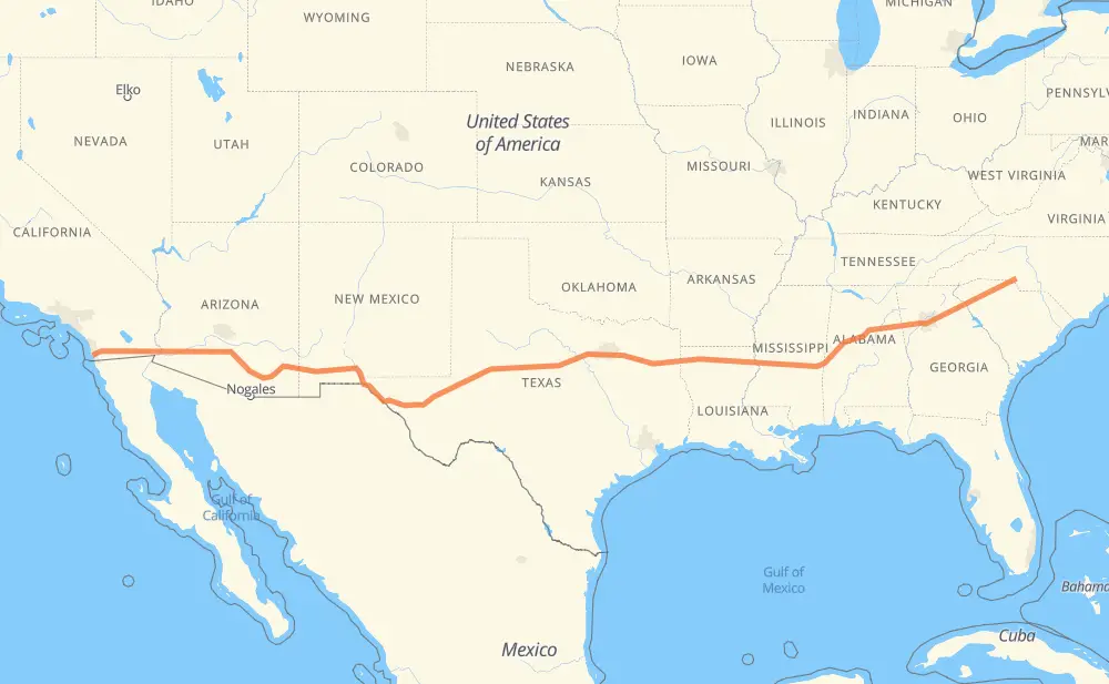
The distance from Charlotte to San Diego is 3,836 kilometers by road including 3,814 kilometers on motorways. Road takes approximately 36 hours and 47 minutes and goes through Greenville, Atlanta, Tuscaloosa, Jackson, Longview, Mesquite and Dallas.
| Shortest distance by air | 3,343 km ✈️ |
| Car route length | 3,836 km 🚗 |
| Driving time | 36 h 47 min |
| Fuel amount | 306.9 L |
| Fuel cost | 454.2 GBP |
| Point | Distance | Time | Fuel | |
| Charlotte | 0 km | 00 min | 0.0 L | |
|
NC 27 I 85 152 km, 1 h 30 min
|
||||
| Greenville | 152 km | 1 h 30 min | 11.6 L | |
|
I 85 238 km, 2 h 15 min
|
||||
| Atlanta | 390 km | 3 h 45 min | 30.2 L | |
|
I 85 I 20 306 km, 2 h 50 min
|
||||
| Tuscaloosa | 696 km | 6 h 35 min | 54.4 L | |
|
I 20 305 km, 2 h 58 min
|
||||
| Jackson | 1,001 km | 9 h 34 min | 79.9 L | |
|
I 20 442 km, 4 h 25 min
|
||||
| Longview | 1,442 km | 13 h 59 min | 115.3 L | |
|
I 20 173 km, 1 h 35 min
|
||||
| Mesquite | 1,615 km | 15 h 35 min | 128.6 L | |
|
I 20 31 km, 18 min
|
||||
| Dallas | 1,647 km | 15 h 53 min | 130.4 L | |
|
I 20 32 km, 18 min
|
||||
| Arlington | 1,679 km | 16 h 12 min | 133.6 L | |
|
I 20 257 km, 2 h 31 min
|
||||
| Abilene | 1,936 km | 18 h 43 min | 153.5 L | |
|
I 20 251 km, 2 h 34 min
|
||||
| Midland | 2,186 km | 21 h 17 min | 174.1 L | |
|
I 20 21 km, 11 min
|
||||
| Odessa | 2,208 km | 21 h 29 min | 175.7 L | |
|
I 20 I 10 462 km, 4 h 10 min
|
||||
| El Paso | 2,669 km | 25 h 39 min | 213.1 L | |
|
Loop 375 I 10 501 km, 5 h 00 min
|
||||
| Tucson | 3,171 km | 30 h 40 min | 251.8 L | |
|
I 10 I 8 394 km, 3 h 35 min
|
||||
| Yuma | 3,565 km | 34 h 15 min | 284.6 L | |
|
I 8 89 km, 47 min
|
||||
| El Centro | 3,654 km | 35 h 03 min | 292.0 L | |
|
I 8 157 km, 1 h 25 min
|
||||
| El Cajon | 3,812 km | 36 h 28 min | 304.8 L | |
|
I 8 25 km, 18 min
|
||||
| San Diego | 3,836 km | 36 h 47 min | 305.9 L | |
Hotels of San Diego
Frequently Asked Questions
How much does it cost to drive from Charlotte to San Diego?
Fuel cost: 454.2 GBP
This fuel cost is calculated as: (Route length 3,836 km / 100 km) * (Fuel consumption 8 L/100 km) * (Fuel price 1.48 GBP / L)
You can adjust fuel consumption and fuel price here.
How long is a car ride from Charlotte to San Diego?
Driving time: 36 h 47 min
This time is calculated for driving at the maximum permitted speed, taking into account traffic rules restrictions.
- 2,387 km with a maximum speed 112 km/h = 21 h 18 min
- 278 km with a maximum speed 105 km/h = 2 h 39 min
- 591 km with a maximum speed 100 km/h = 5 h 54 min
- 149 km with a maximum speed 97 km/h = 1 h 32 min
- 2 km with a maximum speed 96 km/h = 1 min
- 26 km with a maximum speed 89 km/h = 17 min
- 399 km with a maximum speed 80 km/h = 4 h 59 min
- 4 km with a maximum speed 72 km/h = 2 min
The calculated driving time does not take into account intermediate stops and traffic jams.
How far is Charlotte to San Diego by land?
The distance between Charlotte and San Diego is 3,836 km by road including 3,814 km on motorways.
Precise satellite coordinates of highways were used for this calculation. The start and finish points are the centers of Charlotte and San Diego respectively.
How far is Charlotte to San Diego by plane?
The shortest distance (air line, as the crow flies) between Charlotte and San Diego is 3,343 km.
This distance is calculated using the Haversine formula as a great-circle distance between two points on the surface of a sphere. The start and finish points are the centers of Charlotte and San Diego respectively. Actual distance between airports may be different.
How many hours is Charlotte from San Diego by plane?
Boeing 737 airliner needs 4 h 10 min to cover the distance of 3,343 km at a cruising speed of 800 km/h.
Small plane "Cessna 172" needs 15 h 11 min to flight this distance at average speed of 220 km/h.
This time is approximate and do not take into account takeoff and landing times, airport location and other real world factors.
How long is a helicopter ride from Charlotte to San Diego?
Fast helicopter "Eurocopter AS350" or "Hughes OH-6 Cayuse" need 13 h 55 min to cover the distance of 3,343 km at a cruising speed of 240 km/h.
Popular "Robinson R44" needs 15 h 55 min to flight this distance at average speed of 210 km/h.
This time is approximate and do not take into account takeoff and landing times, aerodrome location and other real world factors.
What city is halfway between Charlotte and San Diego?
The halfway point between Charlotte and San Diego is Clyde. It is located about 4 km from the exact midpoint by road.
The distance from Clyde to Charlotte is 1,914 km and driving will take about 18 h 28 min. The road between Clyde and San Diego has length 1,922 km and will take approximately 18 h 18 min.
The other cities located close to halfway point:
Where is Charlotte in relation to San Diego?
Charlotte is located 3,343 km east of San Diego.
Charlotte has geographic coordinates: latitude 35.22708, longitude -80.84313.
San Diego has geographic coordinates: latitude 32.71741, longitude -117.16277.
Which highway goes from Charlotte to San Diego?
The route from Charlotte to San Diego follows I 20, I 10, I 8, I 85, I 59, US 70, US 180.
Other minor sections pass along the road:
- US 80: 79 km
- US 84: 64 km
- I 459: 39 km
- Loop 375: 33 km
- US 191: 32 km
- I 85 Toll: 25 km
- US 29: 24 km
- US 11: 24 km
- US 85: 21 km
- TX 349: 14 km
- CA 94: 14 km
- AL 5: 13 km
- US 259: 11 km
- TX 158: 9 km
- US 49: 7 km
- I-459: 7 km
- MS 19: 6 km
- US 61: 6 km
- US 87: 5 km
- US 431: 5 km
- NC 27: 5 km
- US 371: 4 km
- US 78: 4 km
- TX 70: 4 km
- TX 108: 3 km
- CA 125: 3 km
- I 55: 3 km
- I 75: 2 km
- US 71: 2 km
- TX 208: 2 km
- US 287: 1 km