Distance between Chemax and Cecilio Terán (Balastrera)
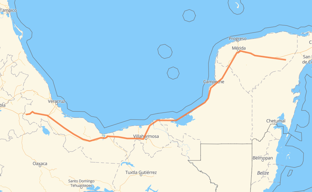
The distance from Chemax to Cecilio Terán (Balastrera) is 1,242 kilometers by road including 560 kilometers on motorways. Road takes approximately 13 hours and 48 minutes and goes through Kanasín, Mérida, Orizaba, Tikuch, X-can, Hoctún and Tahmek.
| Shortest distance by air | 993 km ✈️ |
| Car route length | 1,242 km 🚗 |
| Driving time | 13 h 48 min |
| Fuel amount | 99.4 L |
| Fuel cost | 148.1 GBP |
| Toll roads cost | 707 + ? MXN |
| Point | Distance | Time | Fuel | |
| Chemax | 0 km | 00 min | 0.0 L | |
|
MEX 180 12 km, 09 min
|
||||
| Tikuch | 12 km | 09 min | 0.1 L | |
|
MEX 180 MEX 180D 119 km, 1 h 25 min
|
||||
| Hoctún | 132 km | 1 h 34 min | 9.8 L | |
|
MEX 180 15 km, 10 min
|
||||
| Tahmek | 147 km | 1 h 45 min | 11.7 L | |
|
MEX 180 31 km, 23 min
|
||||
| Kanasín | 178 km | 2 h 08 min | 13.9 L | |
|
MEX 180 11 km, 07 min
|
||||
| Mérida | 189 km | 2 h 16 min | 14.6 L | |
|
MEX 180 32 km, 20 min
|
||||
| Chocholá | 221 km | 2 h 37 min | 17.6 L | |
|
MEX 180 14 km, 10 min
|
||||
| Kopomá | 235 km | 2 h 47 min | 18.7 L | |
|
MEX 180 990 km, 10 h 48 min
|
||||
| Orizaba | 1,225 km | 13 h 35 min | 97.7 L | |
|
MEX 150D 17 km, 12 min
|
||||
| Cecilio Terán (Balastrera) | 1,242 km | 13 h 48 min | 99.0 L | |
Frequently Asked Questions
How many toll booths are there from Chemax to Cecilio Terán (Balastrera)?
There are 11 toll booths between Chemax and Cecilio Terán (Balastrera): Fortín, Cuitláhuac, Cosamaloapan, Acayucan, Antonio Dovali, Sánchez Magallanes, Villahermosa Nacajuca, Zacatal, Unidad, Seybaplaya and Pisté.
How much does the toll booths cost from Chemax to Cecilio Terán (Balastrera)?
Toll roads cost: Pisté (?) + Seybaplaya (77 MXN) + Unidad (?) + Zacatal (90 MXN) + Villahermosa Nacajuca (62 MXN) + Sánchez Magallanes (82 MXN) + Antonio Dovali (20 MXN) + Acayucan (?) + Cosamaloapan (229 MXN) + Cuitláhuac (114 MXN) + Fortín (33 MXN) = 707 + ? MXN
How much does it cost to drive from Chemax to Cecilio Terán (Balastrera)?
Fuel cost: 148.1 GBP
This fuel cost is calculated as: (Route length 1,242 km / 100 km) * (Fuel consumption 8 L/100 km) * (Fuel price 1.49 GBP / L)
You can adjust fuel consumption and fuel price here.
Toll roads cost: 707 + ? MXN
How long is a car ride from Chemax to Cecilio Terán (Balastrera)?
Driving time: 13 h 48 min
This time is calculated for driving at the maximum permitted speed, taking into account traffic rules restrictions.
- 113 km with a maximum speed 110 km/h = 1 h 1 min
- 311 km with a maximum speed 100 km/h = 3 h 6 min
- 204 km with a maximum speed 96 km/h = 2 h 7 min
- 110 km with a maximum speed 90 km/h = 1 h 13 min
- 500 km with a maximum speed 80 km/h = 6 h 15 min
- 2 km with a maximum speed 60 km/h = 1 min
- 1 km with a maximum speed 50 km/h = 1 min
The calculated driving time does not take into account intermediate stops and traffic jams.
How far is Chemax to Cecilio Terán (Balastrera) by land?
The distance between Chemax and Cecilio Terán (Balastrera) is 1,242 km by road including 560 km on motorways.
Precise satellite coordinates of highways were used for this calculation. The start and finish points are the centers of Chemax and Cecilio Terán (Balastrera) respectively.
How far is Chemax to Cecilio Terán (Balastrera) by plane?
The shortest distance (air line, as the crow flies) between Chemax and Cecilio Terán (Balastrera) is 993 km.
This distance is calculated using the Haversine formula as a great-circle distance between two points on the surface of a sphere. The start and finish points are the centers of Chemax and Cecilio Terán (Balastrera) respectively. Actual distance between airports may be different.
How many hours is Chemax from Cecilio Terán (Balastrera) by plane?
Boeing 737 airliner needs 1 h 14 min to cover the distance of 993 km at a cruising speed of 800 km/h.
Small plane "Cessna 172" needs 4 h 30 min to flight this distance at average speed of 220 km/h.
This time is approximate and do not take into account takeoff and landing times, airport location and other real world factors.
How long is a helicopter ride from Chemax to Cecilio Terán (Balastrera)?
Fast helicopter "Eurocopter AS350" or "Hughes OH-6 Cayuse" need 4 h 8 min to cover the distance of 993 km at a cruising speed of 240 km/h.
Popular "Robinson R44" needs 4 h 43 min to flight this distance at average speed of 210 km/h.
This time is approximate and do not take into account takeoff and landing times, aerodrome location and other real world factors.
What city is halfway between Chemax and Cecilio Terán (Balastrera)?
The halfway point between Chemax and Cecilio Terán (Balastrera) is Atasta. It is located about 17 km from the exact midpoint by road.
The distance from Atasta to Chemax is 604 km and driving will take about 6 h 59 min. The road between Atasta and Cecilio Terán (Balastrera) has length 638 km and will take approximately 6 h 48 min.
The other cities located close to halfway point:
Where is Chemax in relation to Cecilio Terán (Balastrera)?
Chemax is located 993 km east of Cecilio Terán (Balastrera).
Chemax has geographic coordinates: latitude 20.65544, longitude -87.93734.
Cecilio Terán (Balastrera) has geographic coordinates: latitude 18.81444, longitude -97.22444.
Which highway goes from Chemax to Cecilio Terán (Balastrera)?
The route from Chemax to Cecilio Terán (Balastrera) follows MEX 180, MEX 145D, MEX 180D.
Other minor sections pass along the road:
- MEX 150D: 89 km
- YUC: 6 km
- MEX 295: 2 km