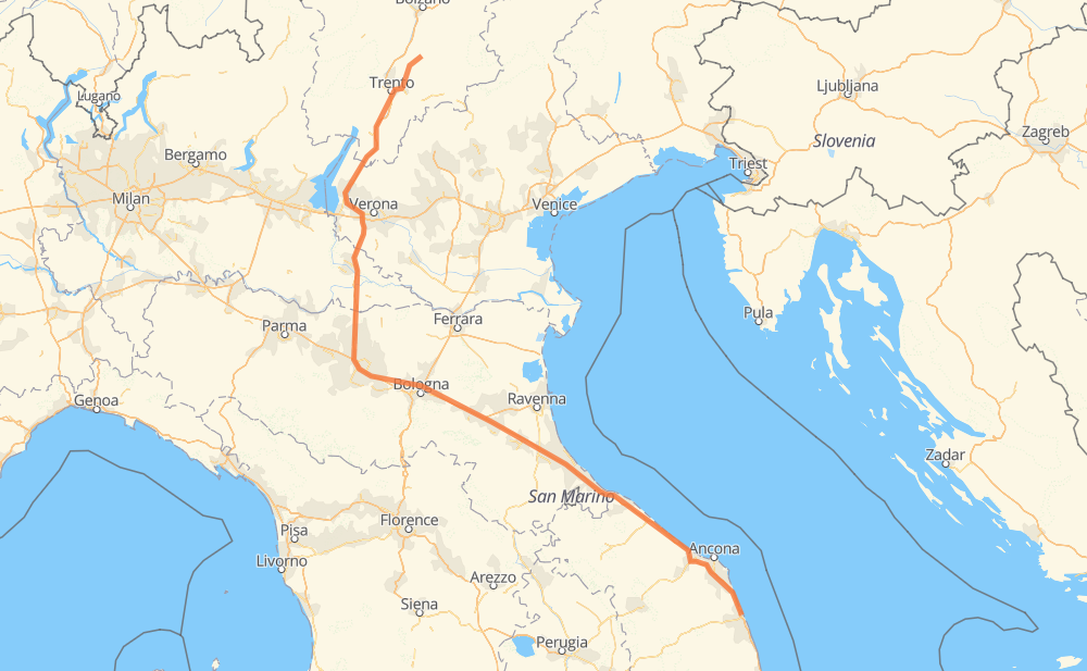
Distance between Civitanova Marche and Valfloriana
The distance from Civitanova Marche to Valfloriana is 515 kilometers by road including 468 kilometers on motorways. Road takes approximately 4 hours and 55 minutes and goes through Ancône, Pesaro, Rimini, Forlì, Bolonia, Módena and Mantua.
| Shortest distance by air | 377 km ✈️ |
| Car route length | 515 km 🚗 |
| Driving time | 4 h 55 min |
| Fuel amount | 41.2 L |
| Fuel cost | 61.4 GBP |
| Point | Distance | Time | Fuel | |
| Civitanova Marche | 0 km | 00 min | 0.0 L | |
|
A14 44 km, 25 min
|
||||
| Ancône | 44 km | 25 min | 2.9 L | |
|
A14 63 km, 33 min
|
||||
| Pesaro | 107 km | 58 min | 7.7 L | |
|
A14 37 km, 19 min
|
||||
| Rimini | 143 km | 1 h 18 min | 10.8 L | |
|
A14 44 km, 23 min
|
||||
| Forlì | 187 km | 1 h 41 min | 14.3 L | |
|
A14 68 km, 38 min
|
||||
| Bolonia | 255 km | 2 h 19 min | 19.7 L | |
|
A14 A1 38 km, 21 min
|
||||
| Módena | 293 km | 2 h 41 min | 22.8 L | |
|
A1 A22 61 km, 33 min
|
||||
| Mantua | 354 km | 3 h 14 min | 28.1 L | |
|
A22 37 km, 19 min
|
||||
| Vérone | 391 km | 3 h 34 min | 30.9 L | |
|
A22 82 km, 46 min
|
||||
| Trient | 472 km | 4 h 21 min | 37.0 L | |
|
A22 SP71 45 km, 34 min
|
||||
| Barcatta | 518 km | 4 h 55 min | 41.2 L | |
Frequently Asked Questions
How much does it cost to drive from Civitanova Marche to Valfloriana?
Fuel cost: 61.4 GBP
This fuel cost is calculated as: (Route length 515 km / 100 km) * (Fuel consumption 8 L/100 km) * (Fuel price 1.49 GBP / L)
You can adjust fuel consumption and fuel price here.
How long is a car ride from Civitanova Marche to Valfloriana?
Driving time: 4 h 55 min
This time is calculated for driving at the maximum permitted speed, taking into account traffic rules restrictions.
- 451 km with a maximum speed 112 km/h = 4 h 1 min
- 12 km with a maximum speed 96 km/h = 7 min
- 38 km with a maximum speed 80 km/h = 28 min
- 2 km with a maximum speed 70 km/h = 1 min
- 8 km with a maximum speed 50 km/h = 9 min
- 2 km with a maximum speed 40 km/h = 3 min
The calculated driving time does not take into account intermediate stops and traffic jams.
How far is Civitanova Marche to Valfloriana by land?
The distance between Civitanova Marche and Valfloriana is 515 km by road including 468 km on motorways.
Precise satellite coordinates of highways were used for this calculation. The start and finish points are the centers of Civitanova Marche and Valfloriana respectively.
How far is Civitanova Marche to Valfloriana by plane?
The shortest distance (air line, as the crow flies) between Civitanova Marche and Valfloriana is 377 km.
This distance is calculated using the Haversine formula as a great-circle distance between two points on the surface of a sphere. The start and finish points are the centers of Civitanova Marche and Valfloriana respectively. Actual distance between airports may be different.
How many hours is Civitanova Marche from Valfloriana by plane?
Boeing 737 airliner needs 28 min to cover the distance of 377 km at a cruising speed of 800 km/h.
Small plane "Cessna 172" needs 1 h 42 min to flight this distance at average speed of 220 km/h.
This time is approximate and do not take into account takeoff and landing times, airport location and other real world factors.
How long is a helicopter ride from Civitanova Marche to Valfloriana?
Fast helicopter "Eurocopter AS350" or "Hughes OH-6 Cayuse" need 1 h 34 min to cover the distance of 377 km at a cruising speed of 240 km/h.
Popular "Robinson R44" needs 1 h 47 min to flight this distance at average speed of 210 km/h.
This time is approximate and do not take into account takeoff and landing times, aerodrome location and other real world factors.
What city is halfway between Civitanova Marche and Valfloriana?
The halfway point between Civitanova Marche and Valfloriana is Bolonia. It is located about 3 km from the exact midpoint by road.
The distance from Bolonia to Civitanova Marche is 255 km and driving will take about 2 h 19 min. The road between Bolonia and Valfloriana has length 260 km and will take approximately 2 h 35 min.
The other cities located close to halfway point:
Where is Civitanova Marche in relation to Valfloriana?
Civitanova Marche is located 377 km south-east of Valfloriana.
Civitanova Marche has geographic coordinates: latitude 43.30552, longitude 13.72293.
Valfloriana has geographic coordinates: latitude 46.24688, longitude 11.34867.
Which highway goes from Civitanova Marche to Valfloriana?
The route from Civitanova Marche to Valfloriana follows A14, A22.
Other minor sections pass along the road:
- A1: 33 km
- SP71: 29 km
- SS47: 4 km
- SP204: 3 km
- SP250: 2 km