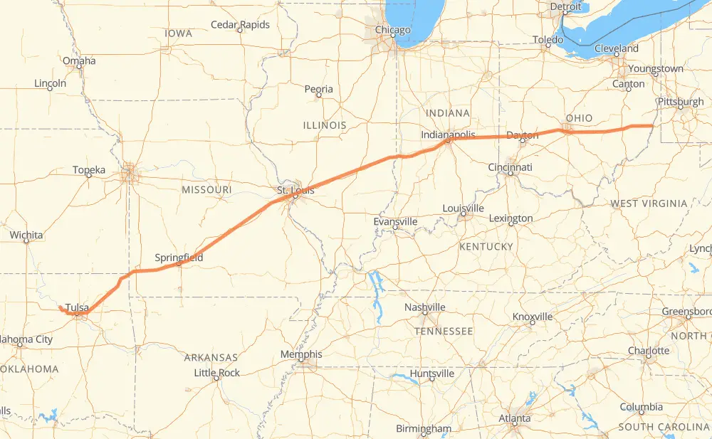
The distance from Cleveland to Aetnaville is 1,560 kilometers by road including 1,545 kilometers on motorways. Road takes approximately 14 hours and 20 minutes and goes through Tulsa, Springfield, Lebanon, St. Louis, Indianapolis and Columbus.
How much does it cost to drive from Cleveland to Aetnaville?
Fuel cost:
184.7 GBP
This fuel cost is calculated as: (Route length 1,560 km / 100 km) * (Fuel consumption 8 L/100 km) * (Fuel price 1.48 GBP / L)
You can adjust fuel consumption and fuel price here.
How long is a car ride from Cleveland to Aetnaville?
Driving time:
14 h 20 min
This time is calculated for driving at the maximum permitted speed, taking into account traffic rules restrictions.
1,220 km with a maximum speed 112 km/h = 10 h 53 min
212 km with a maximum speed 105 km/h = 2 h 1 min
4 km with a maximum speed 100 km/h = 2 min
47 km with a maximum speed 97 km/h = 29 min
11 km with a maximum speed 96 km/h = 6 min
45 km with a maximum speed 89 km/h = 30 min
16 km with a maximum speed 80 km/h = 11 min
4 km with a maximum speed 80 km/h = 2 min
The calculated driving time does not take into account intermediate stops and traffic jams.
How far is Cleveland to Aetnaville by land?
The distance between Cleveland and Aetnaville is 1,560 km by road including 1,545 km on motorways.
Precise satellite coordinates of highways were used for this calculation. The start and finish points are the centers of Cleveland and Aetnaville respectively.
How far is Cleveland to Aetnaville by plane?
The shortest distance (air line, as the crow flies) between Cleveland and Aetnaville is 1,435 km.
This distance is calculated using the Haversine formula as a great-circle distance between two points on the surface of a sphere. The start and finish points are the centers of Cleveland and Aetnaville respectively. Actual distance between airports may be different.
How many hours is Cleveland from Aetnaville by plane?
Boeing 737 airliner needs 1 h 47 min to cover the distance of 1,435 km at a cruising speed of 800 km/h.
Small plane "Cessna 172" needs 6 h 31 min to flight this distance at average speed of 220 km/h.
This time is approximate and do not take into account takeoff and landing times, airport location and other real world factors.
How long is a helicopter ride from Cleveland to Aetnaville?
Fast helicopter "Eurocopter AS350" or "Hughes OH-6 Cayuse" need 5 h 58 min to cover the distance of 1,435 km at a cruising speed of 240 km/h.
Popular "Robinson R44" needs 6 h 50 min to flight this distance at average speed of 210 km/h.
This time is approximate and do not take into account takeoff and landing times, aerodrome location and other real world factors.
What city is halfway between Cleveland and Aetnaville?
The halfway point between Cleveland and Aetnaville is Vandalia. It is located about 11 km from the exact midpoint by road.
The distance from Vandalia to Cleveland is 791 km and driving will take about 7 h 14 min. The road between Vandalia and Aetnaville has length 769 km and will take approximately 7 h 5 min.
The other cities located close to halfway point:
Greenville is in 767 km from Cleveland and 793 km from Aetnaville
Stubblefield is in 759 km from Cleveland and 800 km from Aetnaville
Pocahontas is in 754 km from Cleveland and 806 km from Aetnaville
Where is Cleveland in relation to Aetnaville?
Cleveland is located 1,435 km west of Aetnaville.
Cleveland has geographic coordinates: latitude 36.31007, longitude -96.46419.
Aetnaville has geographic coordinates: latitude 40.08341, longitude -80.73731.
Which highway goes from Cleveland to Aetnaville?
The route from Cleveland to Aetnaville follows I 70, I 44.