Distance between Coyhaique and Aeropuerto
The distance from Coyhaique to Aeropuerto is 1,326 kilometers by road. Road takes approximately 15 hours and 50 minutes and goes through Polo Productivo, Bajo Caracoles, Las Horquetas, Gobernador Gregores, Comandante Luis Piedrabuena, Lemarchand and Ototel Aike.
| Shortest distance by air | 964 km ✈️ |
| Car route length | 1,326 km 🚗 |
| Driving time | 15 h 50 min |
| Fuel amount | 106.1 L |
| Fuel cost | 158.1 GBP |
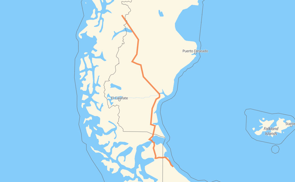
| Point | Distance | Time | Fuel | |
| Coyhaique | 0 km | 00 min | 0.0 L | |
|
7 RP45 174 km, 2 h 43 min
|
||||
| Polo Productivo | 174 km | 2 h 43 min | 13.7 L | |
|
RP45 RN40 144 km, 1 h 32 min
|
||||
| Bajo Caracoles | 318 km | 4 h 16 min | 24.1 L | |
|
RN40 151 km, 1 h 36 min
|
||||
| Las Horquetas | 468 km | 5 h 52 min | 32.6 L | |
|
RN40 65 km, 41 min
|
||||
| Gobernador Gregores | 533 km | 6 h 33 min | 42.3 L | |
|
RN40 RP27 158 km, 1 h 44 min
|
||||
| Comandante Luis Piedrabuena | 691 km | 8 h 17 min | 52.2 L | |
|
RN288 RN3 107 km, 1 h 11 min
|
||||
| Lemarchand | 798 km | 9 h 29 min | 61.4 L | |
|
RN3 51 km, 31 min
|
||||
| Ototel Aike | 849 km | 10 h 01 min | 66.3 L | |
|
RN3 80 km, 51 min
|
||||
| Güer Aike | 928 km | 10 h 52 min | 72.6 L | |
|
RN3 RN2V3 28 km, 21 min
|
||||
| Santa Cruz | 957 km | 11 h 13 min | 76.4 L | |
|
RN2V3 257-CH 370 km, 4 h 36 min
|
||||
| -53.78125, -67.75536 | 1,326 km | 15 h 49 min | 106.1 L | |
Frequently Asked Questions
How much does it cost to drive from Coyhaique to Aeropuerto?
Fuel cost: 158.1 GBP
This fuel cost is calculated as: (Route length 1,326 km / 100 km) * (Fuel consumption 8 L/100 km) * (Fuel price 1.49 GBP / L)
You can adjust fuel consumption and fuel price here.
How long is a car ride from Coyhaique to Aeropuerto?
Driving time: 15 h 50 min
This time is calculated for driving at the maximum permitted speed, taking into account traffic rules restrictions.
- 803 km with a maximum speed 96 km/h = 8 h 22 min
- 478 km with a maximum speed 80 km/h = 5 h 58 min
- 6 km with a maximum speed 60 km/h = 5 min
- 18 km with a maximum speed 50 km/h = 21 min
- 20 km with a maximum speed 20 km/h = 1 h 1 min
The calculated driving time does not take into account intermediate stops and traffic jams.
How far is Coyhaique to Aeropuerto by land?
The distance between Coyhaique and Aeropuerto is 1,326 km by road.
Precise satellite coordinates of highways were used for this calculation. The start and finish points are the centers of Coyhaique and Aeropuerto respectively.
How far is Coyhaique to Aeropuerto by plane?
The shortest distance (air line, as the crow flies) between Coyhaique and Aeropuerto is 964 km.
This distance is calculated using the Haversine formula as a great-circle distance between two points on the surface of a sphere. The start and finish points are the centers of Coyhaique and Aeropuerto respectively. Actual distance between airports may be different.
How many hours is Coyhaique from Aeropuerto by plane?
Boeing 737 airliner needs 1 h 12 min to cover the distance of 964 km at a cruising speed of 800 km/h.
Small plane "Cessna 172" needs 4 h 22 min to flight this distance at average speed of 220 km/h.
This time is approximate and do not take into account takeoff and landing times, airport location and other real world factors.
How long is a helicopter ride from Coyhaique to Aeropuerto?
Fast helicopter "Eurocopter AS350" or "Hughes OH-6 Cayuse" need 4 h 1 min to cover the distance of 964 km at a cruising speed of 240 km/h.
Popular "Robinson R44" needs 4 h 35 min to flight this distance at average speed of 210 km/h.
This time is approximate and do not take into account takeoff and landing times, aerodrome location and other real world factors.
What city is halfway between Coyhaique and Aeropuerto?
The halfway point between Coyhaique and Aeropuerto is Comandante Luis Piedrabuena. It is located about 28 km from the exact midpoint by road.
The distance from Comandante Luis Piedrabuena to Coyhaique is 691 km and driving will take about 8 h 17 min. The road between Comandante Luis Piedrabuena and Aeropuerto has length 635 km and will take approximately 7 h 32 min.
The other cities located close to halfway point:
Where is Coyhaique in relation to Aeropuerto?
Coyhaique is located 964 km north-west of Aeropuerto.
Coyhaique has geographic coordinates: latitude -45.57118, longitude -72.06849.
Aeropuerto has geographic coordinates: latitude -53.78125, longitude -67.75536.
Which highway goes from Coyhaique to Aeropuerto?
The route from Coyhaique to Aeropuerto follows RN40, RN3, 257-CH, RP27.
Other minor sections pass along the road:
- RP45: 95 km
- RN288: 83 km
- 255-CH: 39 km
- 7: 38 km
- 245-CH: 20 km
- RP1: 11 km
- RN2V3: 9 km
- Y-663: 8 km
- RN260: 5 km
- RP7: 5 km
- RP5: 2 km