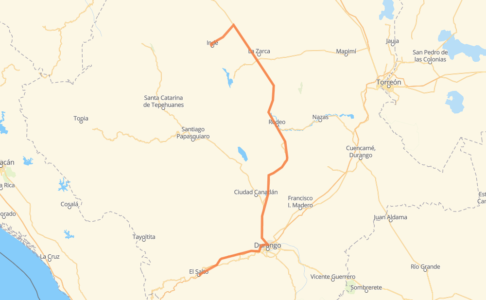
Distance between El Salto and Indé
The distance from El Salto to Indé is 401 kilometers by road. Road takes approximately 4 hours and 36 minutes and goes through Fracc. San Miguel de Casa Blanca, Donato Guerra, Rodeo, Coyotes, Llano Grande, La Perla and La Joya.
| Shortest distance by air | 238 km ✈️ |
| Car route length | 401 km 🚗 |
| Driving time | 4 h 36 min |
| Fuel amount | 32.1 L |
| Fuel cost | 47.8 GBP |
| Toll roads cost | 167 MXN |
| Point | Distance | Time | Fuel | |
| El Salto | 0 km | 00 min | 0.0 L | |
|
MEX 40 MEX 40D 20 km, 14 min
|
||||
| Llano Grande | 20 km | 14 min | 1.4 L | |
|
MEX 40D 81 km, 55 min
|
||||
| Fracc. San Miguel de Casa Blanca | 101 km | 1 h 10 min | 8.0 L | |
|
MEX 45 6 km, 04 min
|
||||
| La Perla | 107 km | 1 h 14 min | 8.3 L | |
|
MEX 45 6 km, 03 min
|
||||
| La Joya | 113 km | 1 h 18 min | 8.9 L | |
|
MEX 45 9 km, 05 min
|
||||
| Cerro Gordo | 122 km | 1 h 24 min | 9.3 L | |
|
MEX 45 10 km, 06 min
|
||||
| La Granja | 132 km | 1 h 30 min | 10.2 L | |
|
MEX 45 22 km, 14 min
|
||||
| Donato Guerra | 154 km | 1 h 45 min | 12.2 L | |
|
MEX 45 89 km, 1 h 00 min
|
||||
| Rodeo | 243 km | 2 h 45 min | 19.0 L | |
|
MEX 45 158 km, 1 h 51 min
|
||||
| Indé | 401 km | 4 h 36 min | 31.8 L | |
Frequently Asked Questions
How many toll booths are there from El Salto to Indé?
There are 2 toll booths between El Salto and Indé: Durango 95 and Llano Grande.
How much does the toll booths cost from El Salto to Indé?
Toll roads cost: Llano Grande (100 MXN) + Durango 95 (67 MXN) = 167 MXN
How much does it cost to drive from El Salto to Indé?
Fuel cost: 47.8 GBP
This fuel cost is calculated as: (Route length 401 km / 100 km) * (Fuel consumption 8 L/100 km) * (Fuel price 1.49 GBP / L)
You can adjust fuel consumption and fuel price here.
Toll roads cost: 167 MXN
How long is a car ride from El Salto to Indé?
Driving time: 4 h 36 min
This time is calculated for driving at the maximum permitted speed, taking into account traffic rules restrictions.
- 102 km with a maximum speed 96 km/h = 1 h 3 min
- 250 km with a maximum speed 90 km/h = 2 h 46 min
- 31 km with a maximum speed 80 km/h = 23 min
- 13 km with a maximum speed 60 km/h = 13 min
- 3 km with a maximum speed 40 km/h = 3 min
- 1 km with a maximum speed 10 km/h = 4 min
The calculated driving time does not take into account intermediate stops and traffic jams.
How far is El Salto to Indé by land?
The distance between El Salto and Indé is 401 km by road.
Precise satellite coordinates of highways were used for this calculation. The start and finish points are the centers of El Salto and Indé respectively.
How far is El Salto to Indé by plane?
The shortest distance (air line, as the crow flies) between El Salto and Indé is 238 km.
This distance is calculated using the Haversine formula as a great-circle distance between two points on the surface of a sphere. The start and finish points are the centers of El Salto and Indé respectively. Actual distance between airports may be different.
How many hours is El Salto from Indé by plane?
Boeing 737 airliner needs 17 min to cover the distance of 238 km at a cruising speed of 800 km/h.
Small plane "Cessna 172" needs 1 h 4 min to flight this distance at average speed of 220 km/h.
This time is approximate and do not take into account takeoff and landing times, airport location and other real world factors.
How long is a helicopter ride from El Salto to Indé?
Fast helicopter "Eurocopter AS350" or "Hughes OH-6 Cayuse" need 59 min to cover the distance of 238 km at a cruising speed of 240 km/h.
Popular "Robinson R44" needs 1 h 8 min to flight this distance at average speed of 210 km/h.
This time is approximate and do not take into account takeoff and landing times, aerodrome location and other real world factors.
What city is halfway between El Salto and Indé?
The halfway point between El Salto and Indé is Atotonilco. It is located about 6 km from the exact midpoint by road.
The distance from Atotonilco to El Salto is 194 km and driving will take about 2 h 12 min. The road between Atotonilco and Indé has length 207 km and will take approximately 2 h 24 min.
The other cities located close to halfway point:
Where is El Salto in relation to Indé?
El Salto is located 238 km south of Indé.
El Salto has geographic coordinates: latitude 23.77994, longitude -105.36169.
Indé has geographic coordinates: latitude 25.91208, longitude -105.22211.
Which highway goes from El Salto to Indé?
The route from El Salto to Indé follows MEX 45.
Other minor sections pass along the road:
- MEX 40D: 71 km
- MEX 40: 14 km