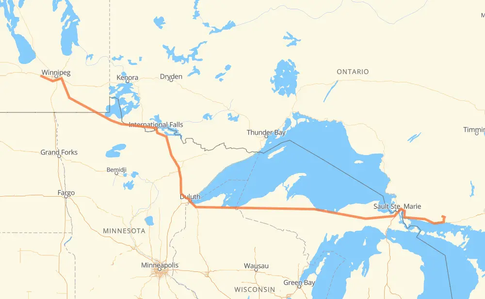
The distance from Elliot Lake to Elie is 1,546 kilometers by road including 54 kilometers on motorways. Road takes approximately 17 hours and 26 minutes and goes through Sault Ste. Marie, Marquette, Duluth, International Falls, Steinbach and Winnipeg.
How much does it cost to drive from Elliot Lake to Elie?
Fuel cost:
183 GBP
This fuel cost is calculated as: (Route length 1,546 km / 100 km) * (Fuel consumption 8 L/100 km) * (Fuel price 1.48 GBP / L)
You can adjust fuel consumption and fuel price here.
How long is a car ride from Elliot Lake to Elie?
Driving time:
17 h 26 min
This time is calculated for driving at the maximum permitted speed, taking into account traffic rules restrictions.
12 km with a maximum speed 105 km/h = 6 min
23 km with a maximum speed 100 km/h = 14 min
731 km with a maximum speed 96 km/h = 7 h 36 min
156 km with a maximum speed 90 km/h = 1 h 44 min
224 km with a maximum speed 89 km/h = 2 h 31 min
5 km with a maximum speed 80 km/h = 4 min
333 km with a maximum speed 80 km/h = 4 h 9 min
18 km with a maximum speed 72 km/h = 15 min
10 km with a maximum speed 70 km/h = 8 min
5 km with a maximum speed 64 km/h = 4 min
6 km with a maximum speed 60 km/h = 6 min
9 km with a maximum speed 56 km/h = 9 min
6 km with a maximum speed 50 km/h = 7 min
6 km with a maximum speed 48 km/h = 7 min
The calculated driving time does not take into account intermediate stops and traffic jams.
How far is Elliot Lake to Elie by land?
The distance between Elliot Lake and Elie is 1,546 km by road including 54 km on motorways.
Precise satellite coordinates of highways were used for this calculation. The start and finish points are the centers of Elliot Lake and Elie respectively.
How far is Elliot Lake to Elie by plane?
The shortest distance (air line, as the crow flies) between Elliot Lake and Elie is 1,185 km.
This distance is calculated using the Haversine formula as a great-circle distance between two points on the surface of a sphere. The start and finish points are the centers of Elliot Lake and Elie respectively. Actual distance between airports may be different.
How many hours is Elliot Lake from Elie by plane?
Boeing 737 airliner needs 1 h 28 min to cover the distance of 1,185 km at a cruising speed of 800 km/h.
Small plane "Cessna 172" needs 5 h 23 min to flight this distance at average speed of 220 km/h.
This time is approximate and do not take into account takeoff and landing times, airport location and other real world factors.
How long is a helicopter ride from Elliot Lake to Elie?
Fast helicopter "Eurocopter AS350" or "Hughes OH-6 Cayuse" need 4 h 56 min to cover the distance of 1,185 km at a cruising speed of 240 km/h.
Popular "Robinson R44" needs 5 h 38 min to flight this distance at average speed of 210 km/h.
This time is approximate and do not take into account takeoff and landing times, aerodrome location and other real world factors.
What city is halfway between Elliot Lake and Elie?
The halfway point between Elliot Lake and Elie is Ashland Junction. It is located about 2 km from the exact midpoint by road.
The distance from Ashland Junction to Elliot Lake is 771 km and driving will take about 8 h 56 min. The road between Ashland Junction and Elie has length 775 km and will take approximately 8 h 30 min.
The other cities located close to halfway point:
Ino is in 790 km from Elliot Lake and 756 km from Elie
Ashland is in 754 km from Elliot Lake and 791 km from Elie
Saxon is in 731 km from Elliot Lake and 815 km from Elie
Where is Elliot Lake in relation to Elie?
Elliot Lake is located 1,185 km east of Elie.
Elliot Lake has geographic coordinates: latitude 46.37346, longitude -82.65289.
Elie has geographic coordinates: latitude 49.90116, longitude -97.75788.
Which highway goes from Elliot Lake to Elie?
The route from Elliot Lake to Elie follows M 28, US 53, US 2, 17, PTH 12.