Distance between Eze and Ijebu-Ife
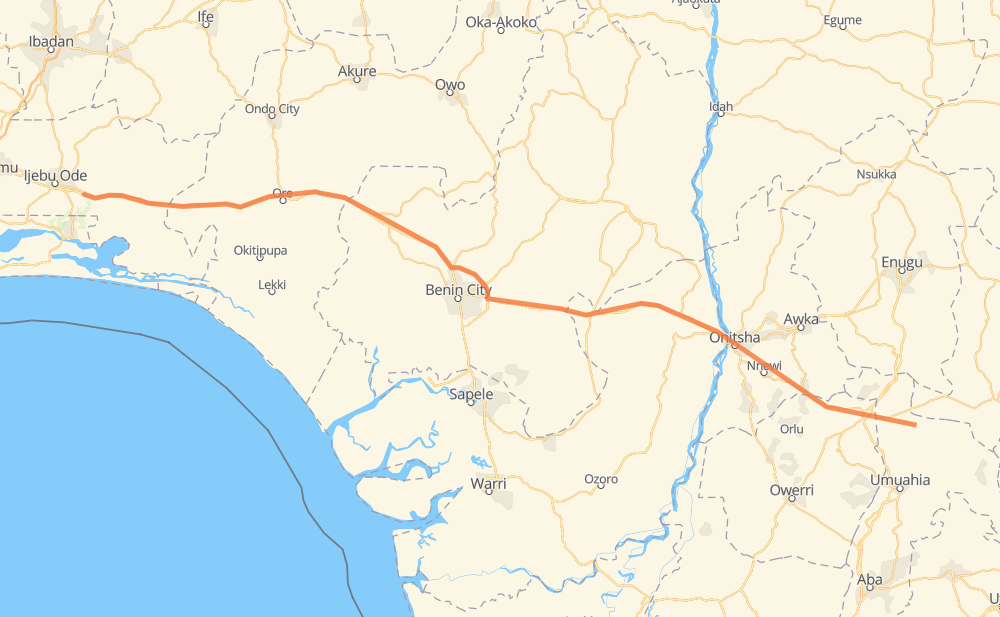
The distance from Eze to Ijebu-Ife is 454 kilometers by road. Road takes approximately 5 hours and 37 minutes and goes through Onitsha, Ijebu-Ode, Nnewi, Asaba and Ore.
| Shortest distance by air | 405 km ✈️ |
| Car route length | 454 km 🚗 |
| Driving time | 5 h 37 min |
| Fuel amount | 36.3 L |
| Fuel cost | 54.1 GBP |
| Point | Distance | Time | Fuel | |
| Eze | 0 km | 00 min | 0.0 L | |
|
5 km, 05 min
|
||||
| Obilago | 5 km | 05 min | 0.0 L | |
|
15 km, 12 min
|
||||
| Onuaku Uturu | 19 km | 18 min | 0.7 L | |
|
14 km, 10 min
|
||||
| Ihube | 33 km | 28 min | 2.4 L | |
|
A3 23 km, 16 min
|
||||
| Amaeshi | 56 km | 45 min | 3.4 L | |
|
31 km, 23 min
|
||||
| Amichi | 88 km | 1 h 08 min | 5.6 L | |
|
19 km, 14 min
|
||||
| Obosi | 107 km | 1 h 23 min | 8.4 L | |
|
A6 6 km, 04 min
|
||||
| Onitsha | 113 km | 1 h 27 min | 8.7 L | |
|
A6 A232 246 km, 2 h 58 min
|
||||
| Ore | 359 km | 4 h 26 min | 27.4 L | |
|
A121-1 95 km, 1 h 11 min
|
||||
| Idofe | 454 km | 5 h 37 min | 36.3 L | |
Frequently Asked Questions
How much does it cost to drive from Eze to Ijebu-Ife?
Fuel cost: 54.1 GBP
This fuel cost is calculated as: (Route length 454 km / 100 km) * (Fuel consumption 8 L/100 km) * (Fuel price 1.49 GBP / L)
You can adjust fuel consumption and fuel price here.
How long is a car ride from Eze to Ijebu-Ife?
Driving time: 5 h 37 min
This time is calculated for driving at the maximum permitted speed, taking into account traffic rules restrictions.
- 54 km with a maximum speed 96 km/h = 34 min
- 391 km with a maximum speed 80 km/h = 4 h 53 min
- 9 km with a maximum speed 50 km/h = 10 min
The calculated driving time does not take into account intermediate stops and traffic jams.
How far is Eze to Ijebu-Ife by land?
The distance between Eze and Ijebu-Ife is 454 km by road.
Precise satellite coordinates of highways were used for this calculation. The start and finish points are the centers of Eze and Ijebu-Ife respectively.
How far is Eze to Ijebu-Ife by plane?
The shortest distance (air line, as the crow flies) between Eze and Ijebu-Ife is 405 km.
This distance is calculated using the Haversine formula as a great-circle distance between two points on the surface of a sphere. The start and finish points are the centers of Eze and Ijebu-Ife respectively. Actual distance between airports may be different.
How many hours is Eze from Ijebu-Ife by plane?
Boeing 737 airliner needs 30 min to cover the distance of 405 km at a cruising speed of 800 km/h.
Small plane "Cessna 172" needs 1 h 50 min to flight this distance at average speed of 220 km/h.
This time is approximate and do not take into account takeoff and landing times, airport location and other real world factors.
How long is a helicopter ride from Eze to Ijebu-Ife?
Fast helicopter "Eurocopter AS350" or "Hughes OH-6 Cayuse" need 1 h 41 min to cover the distance of 405 km at a cruising speed of 240 km/h.
Popular "Robinson R44" needs 1 h 55 min to flight this distance at average speed of 210 km/h.
This time is approximate and do not take into account takeoff and landing times, aerodrome location and other real world factors.
What city is halfway between Eze and Ijebu-Ife?
The halfway point between Eze and Ijebu-Ife is Aduhanhan. It is located about 5 km from the exact midpoint by road.
The distance from Aduhanhan to Eze is 232 km and driving will take about 2 h 56 min. The road between Aduhanhan and Ijebu-Ife has length 222 km and will take approximately 2 h 41 min.
The other cities located close to halfway point:
Where is Eze in relation to Ijebu-Ife?
Eze is located 405 km south-east of Ijebu-Ife.
Eze has geographic coordinates: latitude 5.8, longitude 7.56667.
Ijebu-Ife has geographic coordinates: latitude 6.77837, longitude 4.03386.
Which highway goes from Eze to Ijebu-Ife?
The route from Eze to Ijebu-Ife follows A121-1, A232.
Other minor sections pass along the road:
- A6: 9 km
- A3: 4 km
- A3-1: 3 km