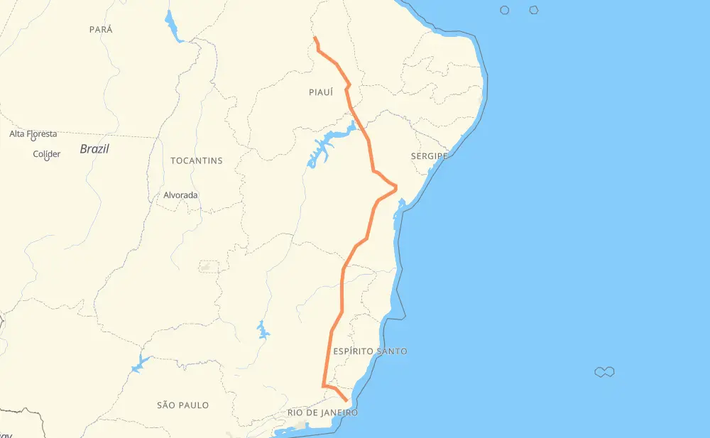
Distance between Fazendinha and Teresina
The distance from Fazendinha to Teresina is 2,429 kilometers by road including 68 kilometers on motorways. Road takes approximately 28 hours and 3 minutes and goes through Muriaé, Juazeiro, Manhães, Vila Menezes, Penha, Vivenda dos Coqueiros 2 and Solar da Penha.
| Shortest distance by air | 1,866 km ✈️ |
| Car route length | 2,429 km 🚗 |
| Driving time | 28 h 3 min |
| Fuel amount | 194.4 L |
| Fuel cost | 289.6 GBP |
| Point | Distance | Time | Fuel | |
| Fazendinha | 0 km | 00 min | 0.0 L | |
|
3 km, 02 min
|
||||
| Manhães | 3 km | 02 min | 0.1 L | |
|
2 km, 01 min
|
||||
| Vivenda dos Coqueiros 2 | 5 km | 04 min | 0.4 L | |
|
BR-356 2 km, 01 min
|
||||
| Parque Vista Alegre | 7 km | 05 min | 0.5 L | |
|
BR-356 2 km, 01 min
|
||||
| Parque Turf Club | 9 km | 07 min | 0.6 L | |
|
BR-356 2 km, 01 min
|
||||
| Parque Rosário | 10 km | 08 min | 0.8 L | |
|
BR-356 1 km, 01 min
|
||||
| Centro | 12 km | 09 min | 0.8 L | |
|
BR-356 160 km, 1 h 53 min
|
||||
| Muriaé | 171 km | 2 h 02 min | 12.3 L | |
|
BR-356 BR-116 1,622 km, 18 h 56 min
|
||||
| Juazeiro | 1,793 km | 20 h 58 min | 142.9 L | |
|
BR-407 645 km, 7 h 04 min
|
||||
| Teresina | 2,438 km | 28 h 03 min | 195.1 L | |
Hotels of Teresina
Frequently Asked Questions
How much does it cost to drive from Fazendinha to Teresina?
Fuel cost: 289.6 GBP
This fuel cost is calculated as: (Route length 2,429 km / 100 km) * (Fuel consumption 8 L/100 km) * (Fuel price 1.49 GBP / L)
You can adjust fuel consumption and fuel price here.
How long is a car ride from Fazendinha to Teresina?
Driving time: 28 h 3 min
This time is calculated for driving at the maximum permitted speed, taking into account traffic rules restrictions.
- 41 km with a maximum speed 110 km/h = 22 min
- 26 km with a maximum speed 100 km/h = 15 min
- 1,423 km with a maximum speed 96 km/h = 14 h 49 min
- 815 km with a maximum speed 80 km/h = 10 h 11 min
- 105 km with a maximum speed 60 km/h = 1 h 44 min
- 7 km with a maximum speed 50 km/h = 8 min
- 21 km with a maximum speed 40 km/h = 31 min
The calculated driving time does not take into account intermediate stops and traffic jams.
How far is Fazendinha to Teresina by land?
The distance between Fazendinha and Teresina is 2,429 km by road including 68 km on motorways.
Precise satellite coordinates of highways were used for this calculation. The start and finish points are the centers of Fazendinha and Teresina respectively.
How far is Fazendinha to Teresina by plane?
The shortest distance (air line, as the crow flies) between Fazendinha and Teresina is 1,866 km.
This distance is calculated using the Haversine formula as a great-circle distance between two points on the surface of a sphere. The start and finish points are the centers of Fazendinha and Teresina respectively. Actual distance between airports may be different.
How many hours is Fazendinha from Teresina by plane?
Boeing 737 airliner needs 2 h 19 min to cover the distance of 1,866 km at a cruising speed of 800 km/h.
Small plane "Cessna 172" needs 8 h 28 min to flight this distance at average speed of 220 km/h.
This time is approximate and do not take into account takeoff and landing times, airport location and other real world factors.
How long is a helicopter ride from Fazendinha to Teresina?
Fast helicopter "Eurocopter AS350" or "Hughes OH-6 Cayuse" need 7 h 46 min to cover the distance of 1,866 km at a cruising speed of 240 km/h.
Popular "Robinson R44" needs 8 h 53 min to flight this distance at average speed of 210 km/h.
This time is approximate and do not take into account takeoff and landing times, aerodrome location and other real world factors.
What city is halfway between Fazendinha and Teresina?
The halfway point between Fazendinha and Teresina is Stela Dubois. It is located about 29 km from the exact midpoint by road.
The distance from Stela Dubois to Fazendinha is 1,186 km and driving will take about 14 h 7 min. The road between Stela Dubois and Teresina has length 1,244 km and will take approximately 13 h 55 min.
The other cities located close to halfway point:
Where is Fazendinha in relation to Teresina?
Fazendinha is located 1,866 km south of Teresina.
Fazendinha has geographic coordinates: latitude -21.79554, longitude -41.25468.
Teresina has geographic coordinates: latitude -5.08964, longitude -42.80959.
Which highway goes from Fazendinha to Teresina?
The route from Fazendinha to Teresina follows BR-116, BR-407, BR-316, BR-356, BR-324.
Other minor sections pass along the road:
- BR-342: 71 km
- BR-230: 42 km
- BA-262: 35 km
- BR-343: 29 km
- BR-251: 15 km
- BR-020: 6 km
- BR-030: 3 km
- PI-459: 2 km
- BR-101: 1 km