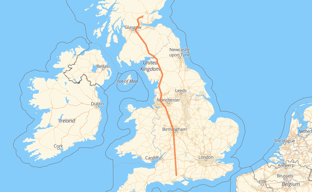
The distance from Fordingbridge to Easter Coul is 731 kilometers by road including 569 kilometers on motorways. Road takes approximately 7 hours and 6 minutes and goes through Salisbury, Carlisle, Amesbury, Tidworth, Marlborough, Cricklade and Bromsgrove.
How much does it cost to drive from Fordingbridge to Easter Coul?
Fuel cost:
87.1 GBP
This fuel cost is calculated as: (Route length 731 km / 100 km) * (Fuel consumption 8 L/100 km) * (Fuel price 1.49 GBP / L)
You can adjust fuel consumption and fuel price here.
How long is a car ride from Fordingbridge to Easter Coul?
Driving time:
7 h 6 min
This time is calculated for driving at the maximum permitted speed, taking into account traffic rules restrictions.
533 km with a maximum speed 112 km/h = 4 h 45 min
18 km with a maximum speed 100 km/h = 10 min
128 km with a maximum speed 96 km/h = 1 h 19 min
9 km with a maximum speed 80 km/h = 6 min
15 km with a maximum speed 80 km/h = 11 min
11 km with a maximum speed 64 km/h = 10 min
15 km with a maximum speed 48 km/h = 19 min
1 km with a maximum speed 20 km/h = 1 min
The calculated driving time does not take into account intermediate stops and traffic jams.
How far is Fordingbridge to Easter Coul by land?
The distance between Fordingbridge and Easter Coul is 731 km by road including 569 km on motorways.
Precise satellite coordinates of highways were used for this calculation. The start and finish points are the centers of Fordingbridge and Easter Coul respectively.
How far is Fordingbridge to Easter Coul by plane?
The shortest distance (air line, as the crow flies) between Fordingbridge and Easter Coul is 610 km.
This distance is calculated using the Haversine formula as a great-circle distance between two points on the surface of a sphere. The start and finish points are the centers of Fordingbridge and Easter Coul respectively. Actual distance between airports may be different.
How many hours is Fordingbridge from Easter Coul by plane?
Boeing 737 airliner needs 45 min to cover the distance of 610 km at a cruising speed of 800 km/h.
Small plane "Cessna 172" needs 2 h 46 min to flight this distance at average speed of 220 km/h.
This time is approximate and do not take into account takeoff and landing times, airport location and other real world factors.
How long is a helicopter ride from Fordingbridge to Easter Coul?
Fast helicopter "Eurocopter AS350" or "Hughes OH-6 Cayuse" need 2 h 32 min to cover the distance of 610 km at a cruising speed of 240 km/h.
Popular "Robinson R44" needs 2 h 54 min to flight this distance at average speed of 210 km/h.
This time is approximate and do not take into account takeoff and landing times, aerodrome location and other real world factors.
What city is halfway between Fordingbridge and Easter Coul?
The halfway point between Fordingbridge and Easter Coul is Euxton. It is located about 1 km from the exact midpoint by road.
The distance from Euxton to Fordingbridge is 365 km and driving will take about 3 h 44 min. The road between Euxton and Easter Coul has length 366 km and will take approximately 3 h 21 min.
The other cities located close to halfway point:
Charnock Richard is in 362 km from Fordingbridge and 369 km from Easter Coul
Hunger Hill is in 356 km from Fordingbridge and 375 km from Easter Coul
Scorton is in 398 km from Fordingbridge and 332 km from Easter Coul
Where is Fordingbridge in relation to Easter Coul?
Fordingbridge is located 610 km south-east of Easter Coul.
Fordingbridge has geographic coordinates: latitude 50.9268, longitude -1.7917.
Easter Coul has geographic coordinates: latitude 56.29619, longitude -3.66322.
Which highway goes from Fordingbridge to Easter Coul?
The route from Fordingbridge to Easter Coul follows M6.