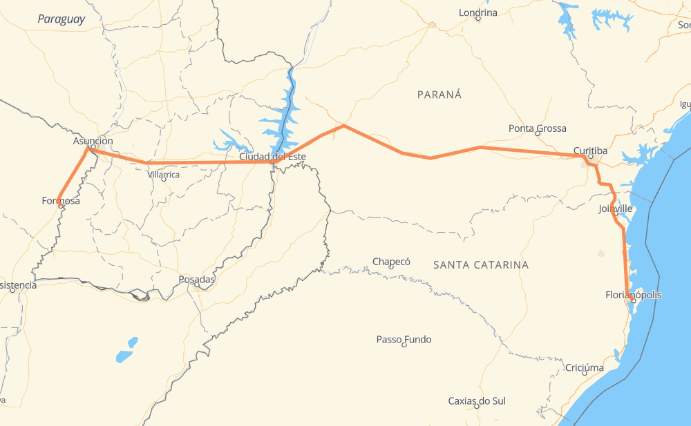
Distance between Formosa and Florianópolis
The distance from Formosa to Florianópolis is 1,394 kilometers by road including 368 kilometers on motorways. Road takes approximately 15 hours and 55 minutes and goes through Lambaré, Fernando de la Mora, San Lorenzo, Capiatá, Itauguá, Ypacaraí and Caaguazú.
| Shortest distance by air | 967 km ✈️ |
| Car route length | 1,394 km 🚗 |
| Driving time | 15 h 55 min |
| Fuel amount | 111.6 L |
| Fuel cost | 166.2 GBP |
| Point | Distance | Time | Fuel | |
| Formosa | 0 km | 00 min | 0.0 L | |
|
RN11 131 km, 1 h 32 min
|
||||
| Lambaré | 131 km | 1 h 32 min | 10.2 L | |
|
PY02 8 km, 05 min
|
||||
| Fernando de la Mora | 139 km | 1 h 37 min | 11.0 L | |
|
PY02 7 km, 04 min
|
||||
| San Lorenzo | 145 km | 1 h 42 min | 11.2 L | |
|
PY02 8 km, 06 min
|
||||
| Capiatá | 154 km | 1 h 48 min | 12.1 L | |
|
PY02 4 km, 03 min
|
||||
| Itauguá | 158 km | 1 h 52 min | 12.5 L | |
|
PY02 7 km, 05 min
|
||||
| Ypacaraí | 165 km | 1 h 58 min | 12.8 L | |
|
PY02 139 km, 1 h 34 min
|
||||
| Caaguazú | 304 km | 3 h 33 min | 23.4 L | |
|
PY02 75 km, 53 min
|
||||
| Juan Emilio O'Leary | 379 km | 4 h 26 min | 30.3 L | |
|
PY02 7 km, 05 min
|
||||
| Doctor Juan León Mallorquín | 387 km | 4 h 31 min | 30.4 L | |
|
PY02 35 km, 24 min
|
||||
| Minga Guazú | 422 km | 4 h 56 min | 31.5 L | |
|
PY02 33 km, 23 min
|
||||
| Ciudad del Este | 454 km | 5 h 19 min | 36.0 L | |
|
PY02 BR-277 144 km, 1 h 45 min
|
||||
| Cascavel | 599 km | 7 h 05 min | 47.5 L | |
|
BR-277 468 km, 5 h 15 min
|
||||
| Campo Largo | 1,067 km | 12 h 21 min | 84.8 L | |
|
BR-277 BR-101 327 km, 3 h 33 min
|
||||
| Florianópolis | 1,394 km | 15 h 55 min | 111.5 L | |
Hotels of Florianópolis
Frequently Asked Questions
How much does it cost to drive from Formosa to Florianópolis?
Fuel cost: 166.2 GBP
This fuel cost is calculated as: (Route length 1,394 km / 100 km) * (Fuel consumption 8 L/100 km) * (Fuel price 1.49 GBP / L)
You can adjust fuel consumption and fuel price here.
How long is a car ride from Formosa to Florianópolis?
Driving time: 15 h 55 min
This time is calculated for driving at the maximum permitted speed, taking into account traffic rules restrictions.
- 82 km with a maximum speed 110 km/h = 44 min
- 199 km with a maximum speed 100 km/h = 1 h 59 min
- 639 km with a maximum speed 96 km/h = 6 h 39 min
- 373 km with a maximum speed 80 km/h = 4 h 39 min
- 10 km with a maximum speed 70 km/h = 8 min
- 73 km with a maximum speed 60 km/h = 1 h 13 min
- 6 km with a maximum speed 50 km/h = 7 min
- 7 km with a maximum speed 40 km/h = 11 min
- 4 km with a maximum speed 20 km/h = 11 min
The calculated driving time does not take into account intermediate stops and traffic jams.
How far is Formosa to Florianópolis by land?
The distance between Formosa and Florianópolis is 1,394 km by road including 368 km on motorways.
Precise satellite coordinates of highways were used for this calculation. The start and finish points are the centers of Formosa and Florianópolis respectively.
How far is Formosa to Florianópolis by plane?
The shortest distance (air line, as the crow flies) between Formosa and Florianópolis is 967 km.
This distance is calculated using the Haversine formula as a great-circle distance between two points on the surface of a sphere. The start and finish points are the centers of Formosa and Florianópolis respectively. Actual distance between airports may be different.
How many hours is Formosa from Florianópolis by plane?
Boeing 737 airliner needs 1 h 12 min to cover the distance of 967 km at a cruising speed of 800 km/h.
Small plane "Cessna 172" needs 4 h 23 min to flight this distance at average speed of 220 km/h.
This time is approximate and do not take into account takeoff and landing times, airport location and other real world factors.
How long is a helicopter ride from Formosa to Florianópolis?
Fast helicopter "Eurocopter AS350" or "Hughes OH-6 Cayuse" need 4 h 1 min to cover the distance of 967 km at a cruising speed of 240 km/h.
Popular "Robinson R44" needs 4 h 36 min to flight this distance at average speed of 210 km/h.
This time is approximate and do not take into account takeoff and landing times, aerodrome location and other real world factors.
What city is halfway between Formosa and Florianópolis?
The halfway point between Formosa and Florianópolis is São Judas Tadeu. It is located about 21 km from the exact midpoint by road.
The distance from São Judas Tadeu to Formosa is 676 km and driving will take about 7 h 56 min. The road between São Judas Tadeu and Florianópolis has length 718 km and will take approximately 7 h 59 min.
The other cities located close to halfway point:
Where is Formosa in relation to Florianópolis?
Formosa is located 967 km west of Florianópolis.
Formosa has geographic coordinates: latitude -26.1853, longitude -58.1745.
Florianópolis has geographic coordinates: latitude -27.5973, longitude -48.54961.
Which highway goes from Formosa to Florianópolis?
The route from Formosa to Florianópolis follows BR-277, PY02, BR-101, RN11.
Other minor sections pass along the road:
- BR-376: 73 km
- BR-373: 38 km
- BR-116: 12 km
- RNA011: 11 km
- BR-282: 6 km
- BR-158: 3 km