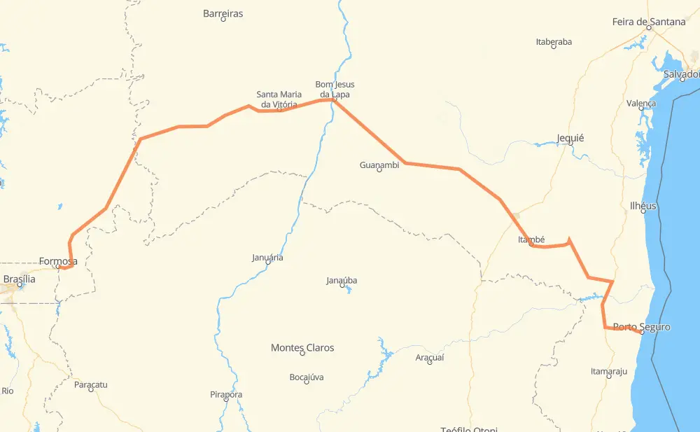
Distance between Formosa and Porto Seguro
The distance from Formosa to Porto Seguro is 1,350 kilometers by road. Road takes approximately 15 hours and 2 minutes and goes through DAIF, Distrito do Bezerra, Distrito de JK, Brás, São Jorge, Felícia and Itambé.
| Shortest distance by air | 889 km ✈️ |
| Car route length | 1,350 km 🚗 |
| Driving time | 15 h 2 min |
| Fuel amount | 108 L |
| Fuel cost | 160.9 GBP |
| Point | Distance | Time | Fuel | |
| -15.54924, -47.33012 | 0 km | 00 min | 0.0 L | |
|
BR-020 5 km, 03 min
|
||||
| DAIF | 5 km | 03 min | 0.6 L | |
|
BR-020 28 km, 19 min
|
||||
| Distrito do Bezerra | 33 km | 22 min | 1.9 L | |
|
BR-020 25 km, 19 min
|
||||
| Distrito de JK | 58 km | 41 min | 4.0 L | |
|
BR-020 197 km, 2 h 05 min
|
||||
| Vila Rosário | 255 km | 2 h 47 min | 20.2 L | |
|
BR-020 BR-349 470 km, 5 h 04 min
|
||||
| Brás | 726 km | 7 h 51 min | 58.0 L | |
|
BR-430 BR-030 106 km, 1 h 14 min
|
||||
| São Jorge | 831 km | 9 h 06 min | 66.6 L | |
|
BA-262 141 km, 1 h 40 min
|
||||
| Felícia | 972 km | 10 h 46 min | 78.0 L | |
|
BR-116 BA-263 47 km, 34 min
|
||||
| Itambé | 1,019 km | 11 h 21 min | 80.1 L | |
|
BA-263 48 km, 32 min
|
||||
| Quintas do Sul 1 | 1,067 km | 11 h 54 min | 85.6 L | |
|
BR-415 BR-101 286 km, 3 h 08 min
|
||||
| Porto Seguro | 1,353 km | 15 h 02 min | 108.4 L | |
Hotels of Porto Seguro
Frequently Asked Questions
How much does it cost to drive from Formosa to Porto Seguro?
Fuel cost: 160.9 GBP
This fuel cost is calculated as: (Route length 1,350 km / 100 km) * (Fuel consumption 8 L/100 km) * (Fuel price 1.49 GBP / L)
You can adjust fuel consumption and fuel price here.
How long is a car ride from Formosa to Porto Seguro?
Driving time: 15 h 2 min
This time is calculated for driving at the maximum permitted speed, taking into account traffic rules restrictions.
- 922 km with a maximum speed 96 km/h = 9 h 36 min
- 427 km with a maximum speed 80 km/h = 5 h 20 min
- 1 km with a maximum speed 60 km/h = 1 min
- 1 km with a maximum speed 40 km/h = 2 min
- 1 km with a maximum speed 30 km/h = 1 min
The calculated driving time does not take into account intermediate stops and traffic jams.
How far is Formosa to Porto Seguro by land?
The distance between Formosa and Porto Seguro is 1,350 km by road.
Precise satellite coordinates of highways were used for this calculation. The start and finish points are the centers of Formosa and Porto Seguro respectively.
How far is Formosa to Porto Seguro by plane?
The shortest distance (air line, as the crow flies) between Formosa and Porto Seguro is 889 km.
This distance is calculated using the Haversine formula as a great-circle distance between two points on the surface of a sphere. The start and finish points are the centers of Formosa and Porto Seguro respectively. Actual distance between airports may be different.
How many hours is Formosa from Porto Seguro by plane?
Boeing 737 airliner needs 1 h 6 min to cover the distance of 889 km at a cruising speed of 800 km/h.
Small plane "Cessna 172" needs 4 h 2 min to flight this distance at average speed of 220 km/h.
This time is approximate and do not take into account takeoff and landing times, airport location and other real world factors.
How long is a helicopter ride from Formosa to Porto Seguro?
Fast helicopter "Eurocopter AS350" or "Hughes OH-6 Cayuse" need 3 h 42 min to cover the distance of 889 km at a cruising speed of 240 km/h.
Popular "Robinson R44" needs 4 h 14 min to flight this distance at average speed of 210 km/h.
This time is approximate and do not take into account takeoff and landing times, aerodrome location and other real world factors.
What city is halfway between Formosa and Porto Seguro?
The halfway point between Formosa and Porto Seguro is Fazenda do Itapicurú. It is located about 13 km from the exact midpoint by road.
The distance from Fazenda do Itapicurú to Formosa is 662 km and driving will take about 7 h 11 min. The road between Fazenda do Itapicurú and Porto Seguro has length 688 km and will take approximately 7 h 51 min.
The other cities located close to halfway point:
Where is Formosa in relation to Porto Seguro?
Formosa is located 889 km west of Porto Seguro.
Formosa has geographic coordinates: latitude -15.54924, longitude -47.33012.
Porto Seguro has geographic coordinates: latitude -16.44348, longitude -39.06425.
Which highway goes from Formosa to Porto Seguro?
The route from Formosa to Porto Seguro follows BR-349, BR-020, BR-430.
Other minor sections pass along the road:
- BA-262: 98 km
- BR-030: 94 km
- BA-263: 92 km
- BR-101: 83 km
- BR-367: 61 km
- BA-680: 58 km
- BA-670: 46 km
- BR-407: 33 km
- BR-415: 25 km
- GO-108: 15 km
- BA-270: 12 km
- BR-116: 9 km