Distance between Francisco Sá and Umbuzeiro
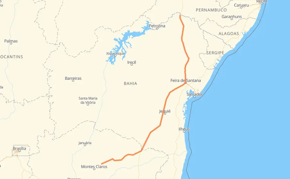
The distance from Francisco Sá to Umbuzeiro is 1,241 kilometers by road including 68 kilometers on motorways. Road takes approximately 14 hours and 20 minutes and goes through Salinas, Felícia, Nossa Senhora Aparecida, Distrito Industrial dos Imborés, Entrocamento do Cem and Teofilândia.
| Shortest distance by air | 982 km ✈️ |
| Car route length | 1,241 km 🚗 |
| Driving time | 14 h 20 min |
| Fuel amount | 99.3 L |
| Fuel cost | 146.9 GBP |
| Point | Distance | Time | Fuel | |
| Francisco Sá | 0 km | 00 min | 0.0 L | |
|
BR-251 86 km, 1 h 03 min
|
||||
| Vale das Cancelas | 86 km | 1 h 03 min | 4.5 L | |
|
BR-251 63 km, 45 min
|
||||
| Salinas | 148 km | 1 h 48 min | 10.5 L | |
|
BR-251 157 km, 1 h 55 min
|
||||
| Divisa Alegre | 305 km | 3 h 43 min | 24.3 L | |
|
BR-116 110 km, 1 h 11 min
|
||||
| Felícia | 415 km | 4 h 54 min | 33.1 L | |
|
BR-116 7 km, 05 min
|
||||
| Nossa Senhora Aparecida | 422 km | 5 h 00 min | 33.8 L | |
|
BR-116 3 km, 02 min
|
||||
| Distrito Industrial dos Imborés | 426 km | 5 h 02 min | 33.8 L | |
|
BR-116 243 km, 2 h 55 min
|
||||
| Entrocamento do Cem | 668 km | 7 h 58 min | 52.9 L | |
|
BR-116 244 km, 2 h 35 min
|
||||
| Teofilândia | 912 km | 10 h 33 min | 72.4 L | |
|
BR-116 334 km, 3 h 45 min
|
||||
| Umbuzeiro | 1,246 km | 14 h 19 min | 99.7 L | |
Frequently Asked Questions
How much does it cost to drive from Francisco Sá to Umbuzeiro?
Fuel cost: 146.9 GBP
This fuel cost is calculated as: (Route length 1,241 km / 100 km) * (Fuel consumption 8 L/100 km) * (Fuel price 1.48 GBP / L)
You can adjust fuel consumption and fuel price here.
How long is a car ride from Francisco Sá to Umbuzeiro?
Driving time: 14 h 20 min
This time is calculated for driving at the maximum permitted speed, taking into account traffic rules restrictions.
- 41 km with a maximum speed 110 km/h = 22 min
- 26 km with a maximum speed 100 km/h = 15 min
- 632 km with a maximum speed 96 km/h = 6 h 34 min
- 494 km with a maximum speed 80 km/h = 6 h 10 min
- 44 km with a maximum speed 60 km/h = 44 min
- 5 km with a maximum speed 50 km/h = 5 min
- 5 km with a maximum speed 40 km/h = 6 min
The calculated driving time does not take into account intermediate stops and traffic jams.
How far is Francisco Sá to Umbuzeiro by land?
The distance between Francisco Sá and Umbuzeiro is 1,241 km by road including 68 km on motorways.
Precise satellite coordinates of highways were used for this calculation. The start and finish points are the centers of Francisco Sá and Umbuzeiro respectively.
How far is Francisco Sá to Umbuzeiro by plane?
The shortest distance (air line, as the crow flies) between Francisco Sá and Umbuzeiro is 982 km.
This distance is calculated using the Haversine formula as a great-circle distance between two points on the surface of a sphere. The start and finish points are the centers of Francisco Sá and Umbuzeiro respectively. Actual distance between airports may be different.
How many hours is Francisco Sá from Umbuzeiro by plane?
Boeing 737 airliner needs 1 h 13 min to cover the distance of 982 km at a cruising speed of 800 km/h.
Small plane "Cessna 172" needs 4 h 27 min to flight this distance at average speed of 220 km/h.
This time is approximate and do not take into account takeoff and landing times, airport location and other real world factors.
How long is a helicopter ride from Francisco Sá to Umbuzeiro?
Fast helicopter "Eurocopter AS350" or "Hughes OH-6 Cayuse" need 4 h 5 min to cover the distance of 982 km at a cruising speed of 240 km/h.
Popular "Robinson R44" needs 4 h 40 min to flight this distance at average speed of 210 km/h.
This time is approximate and do not take into account takeoff and landing times, aerodrome location and other real world factors.
What city is halfway between Francisco Sá and Umbuzeiro?
The halfway point between Francisco Sá and Umbuzeiro is Stela Dubois. It is located about 13 km from the exact midpoint by road.
The distance from Stela Dubois to Francisco Sá is 608 km and driving will take about 7 h 17 min. The road between Stela Dubois and Umbuzeiro has length 633 km and will take approximately 7 h 2 min.
The other cities located close to halfway point:
Where is Francisco Sá in relation to Umbuzeiro?
Francisco Sá is located 982 km south-west of Umbuzeiro.
Francisco Sá has geographic coordinates: latitude -16.47773, longitude -43.49426.
Umbuzeiro has geographic coordinates: latitude -8.67831, longitude -39.26003.
Which highway goes from Francisco Sá to Umbuzeiro?
The route from Francisco Sá to Umbuzeiro follows BR-116, BR-251.
Other minor sections pass along the road:
- BA-262: 35 km
- BR-030: 3 km