Distance between Gobernador Virasoro and Las Rosas
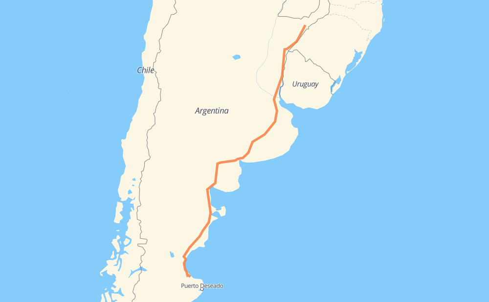
The distance from Gobernador Virasoro to Las Rosas is 2,766 kilometers by road. Road takes approximately 30 hours and 25 minutes and goes through Alvear, Zárate, Bahía Blanca, Comodoro Rivadavia and Caleta Olivia.
| Shortest distance by air | 2,311 km ✈️ |
| Car route length | 2,766 km 🚗 |
| Driving time | 30 h 25 min |
| Fuel amount | 221.3 L |
| Fuel cost | 329.7 GBP |
| Point | Distance | Time | Fuel | |
| Gobernador Virasoro | 0 km | 00 min | 0.0 L | |
|
RN14 44 km, 34 min
|
||||
| Santo Tomé | 44 km | 34 min | 1.6 L | |
|
RN14 102 km, 1 h 07 min
|
||||
| Alvear | 147 km | 1 h 42 min | 11.5 L | |
|
RN14 474 km, 4 h 59 min
|
||||
| Barrio Hipódromo | 621 km | 6 h 41 min | 49.2 L | |
|
RN14 188 km, 1 h 58 min
|
||||
| Zárate | 809 km | 8 h 40 min | 63.6 L | |
|
RN12 RP6 20 km, 13 min
|
||||
| Campana | 829 km | 8 h 54 min | 66.0 L | |
|
RP6 28 km, 18 min
|
||||
| Parque Sakura | 857 km | 9 h 13 min | 68.3 L | |
|
RP6 84 km, 55 min
|
||||
| Cañuelas | 940 km | 10 h 08 min | 75.1 L | |
|
RN3 2,010 km, 22 h 29 min
|
||||
| Comodoro Rivadavia | 2,951 km | 32 h 37 min | 236.0 L | |
|
RN3 165 km, 2 h 21 min
|
||||
| Las Rosas | 3,116 km | 34 h 59 min | 248.8 L | |
Frequently Asked Questions
How much does it cost to drive from Gobernador Virasoro to Las Rosas?
Fuel cost: 329.7 GBP
This fuel cost is calculated as: (Route length 2,766 km / 100 km) * (Fuel consumption 8 L/100 km) * (Fuel price 1.49 GBP / L)
You can adjust fuel consumption and fuel price here.
How long is a car ride from Gobernador Virasoro to Las Rosas?
Driving time: 30 h 25 min
This time is calculated for driving at the maximum permitted speed, taking into account traffic rules restrictions.
- 2,450 km with a maximum speed 96 km/h = 25 h 30 min
- 190 km with a maximum speed 80 km/h = 2 h 22 min
- 9 km with a maximum speed 65 km/h = 8 min
- 73 km with a maximum speed 60 km/h = 1 h 13 min
- 26 km with a maximum speed 50 km/h = 31 min
- 10 km with a maximum speed 40 km/h = 15 min
- 8 km with a maximum speed 20 km/h = 24 min
The calculated driving time does not take into account intermediate stops and traffic jams.
How far is Gobernador Virasoro to Las Rosas by land?
The distance between Gobernador Virasoro and Las Rosas is 2,766 km by road.
Precise satellite coordinates of highways were used for this calculation. The start and finish points are the centers of Gobernador Virasoro and Las Rosas respectively.
How far is Gobernador Virasoro to Las Rosas by plane?
The shortest distance (air line, as the crow flies) between Gobernador Virasoro and Las Rosas is 2,311 km.
This distance is calculated using the Haversine formula as a great-circle distance between two points on the surface of a sphere. The start and finish points are the centers of Gobernador Virasoro and Las Rosas respectively. Actual distance between airports may be different.
How many hours is Gobernador Virasoro from Las Rosas by plane?
Boeing 737 airliner needs 2 h 53 min to cover the distance of 2,311 km at a cruising speed of 800 km/h.
Small plane "Cessna 172" needs 10 h 30 min to flight this distance at average speed of 220 km/h.
This time is approximate and do not take into account takeoff and landing times, airport location and other real world factors.
How long is a helicopter ride from Gobernador Virasoro to Las Rosas?
Fast helicopter "Eurocopter AS350" or "Hughes OH-6 Cayuse" need 9 h 37 min to cover the distance of 2,311 km at a cruising speed of 240 km/h.
Popular "Robinson R44" needs 11 h to flight this distance at average speed of 210 km/h.
This time is approximate and do not take into account takeoff and landing times, aerodrome location and other real world factors.
What city is halfway between Gobernador Virasoro and Las Rosas?
The halfway point between Gobernador Virasoro and Las Rosas is Coronel Pringles. It is located about 10 km from the exact midpoint by road.
The distance from Coronel Pringles to Gobernador Virasoro is 1,373 km and driving will take about 14 h 53 min. The road between Coronel Pringles and Las Rosas has length 1,393 km and will take approximately 15 h 32 min.
The other cities located close to halfway point:
Where is Gobernador Virasoro in relation to Las Rosas?
Gobernador Virasoro is located 2,311 km north-east of Las Rosas.
Gobernador Virasoro has geographic coordinates: latitude -28.0529, longitude -56.0184.
Las Rosas has geographic coordinates: latitude -46.96121, longitude -67.02573.
Which highway goes from Gobernador Virasoro to Las Rosas?
The route from Gobernador Virasoro to Las Rosas follows RN3, RN14, RP51, RN251, RN22, RP6.
Other minor sections pass along the road:
- 007-05: 89 km
- RN12: 76 km
- RN33: 44 km
- RN226: 34 km
- RP85: 4 km
- RP40: 1 km