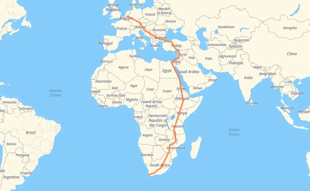
Distance between Goirle and Hout Bay
The distance from Goirle to Hout Bay is 14,676 kilometers by road including 4,296 kilometers on motorways. Road takes approximately 164 hours and 11 minutes and goes through Wiesbaden, Offenbach del Meno, Nuremberg, Graz, Zagreb, Belgrade and Nis.
| Shortest distance by air | 9,606 km ✈️ |
| Car route length | 14,676 km 🚗 |
| Driving time | 164 h 11 min |
| Fuel amount | 1,174.1 L |
| Fuel cost | 1,737.7 GBP |
| Point | Distance | Time | Fuel | |
| Goirle | 0 km | 00 min | 0.0 L | |
|
A 3 339 km, 3 h 35 min
|
||||
| Wiesbaden | 339 km | 3 h 35 min | 26.7 L | |
|
A 3 36 km, 22 min
|
||||
| Offenbach del Meno | 375 km | 3 h 58 min | 29.9 L | |
|
A 3 208 km, 2 h 14 min
|
||||
| Nuremberg | 584 km | 6 h 12 min | 46.3 L | |
|
A 3 491 km, 4 h 57 min
|
||||
| Graz | 1,074 km | 11 h 10 min | 85.4 L | |
|
A9 A2 177 km, 1 h 42 min
|
||||
| Zagreb | 1,251 km | 12 h 53 min | 99.4 L | |
|
A3 407 km, 3 h 43 min
|
||||
| Belgrade | 1,658 km | 16 h 37 min | 129.7 L | |
|
A1 225 km, 2 h 02 min
|
||||
| Nis | 1,883 km | 18 h 39 min | 150.5 L | |
|
A4 152 km, 1 h 34 min
|
||||
| Sofia | 2,035 km | 20 h 14 min | 162.3 L | |
|
8 A 1 122 km, 1 h 09 min
|
||||
| Pazardzhik | 2,157 km | 21 h 23 min | 171.0 L | |
|
A 1 99 km, 53 min
|
||||
| Dimitrovgrad | 2,256 km | 22 h 17 min | 179.2 L | |
|
A 4 16 km, 08 min
|
||||
| Haskovo | 2,272 km | 22 h 25 min | 181.8 L | |
|
A 4 87 km, 52 min
|
||||
| Edirne | 2,360 km | 23 h 18 min | 188.3 L | |
|
O-3 O-4 1,404 km, 15 h 04 min
|
||||
| Idlib | 3,764 km | 38 h 23 min | 300.4 L | |
|
52 km, 35 min
|
||||
| Maarrat al-Nu'man | 3,815 km | 38 h 59 min | 303.2 L | |
|
M5 108 km, 1 h 10 min
|
||||
| Homs | 3,923 km | 40 h 10 min | 313.6 L | |
|
M5 273 km, 2 h 37 min
|
||||
| Daraa | 4,196 km | 42 h 48 min | 335.4 L | |
|
109 25 29 km, 20 min
|
||||
| Irbid | 4,225 km | 43 h 08 min | 337.3 L | |
|
10 71 79 km, 56 min
|
||||
| Afula | 4,304 km | 44 h 05 min | 344.1 L | |
|
65 6 101 km, 1 h 00 min
|
||||
| Rishon LeZion | 4,405 km | 45 h 06 min | 352.0 L | |
|
4 40 km, 25 min
|
||||
| Ashkelon | 4,445 km | 45 h 31 min | 355.3 L | |
|
4 107 km, 1 h 20 min
|
||||
| Al Arish | 4,551 km | 46 h 52 min | 363.9 L | |
|
153 185 km, 2 h 06 min
|
||||
| Al Ismailiya | 4,736 km | 48 h 59 min | 377.8 L | |
|
15 229 km, 2 h 11 min
|
||||
| Zaafaranah | 4,966 km | 51 h 10 min | 396.8 L | |
|
104 km, 1 h 04 min
|
||||
| Ras Gharib | 5,070 km | 52 h 15 min | 397.7 L | |
|
11 221 km, 2 h 19 min
|
||||
| Safaga | 5,291 km | 54 h 34 min | 421.2 L | |
|
11 67 km, 44 min
|
||||
| Al Qusair | 5,357 km | 55 h 19 min | 428.3 L | |
|
11 139 km, 1 h 30 min
|
||||
| Marsa Alam | 5,497 km | 56 h 49 min | 438.9 L | |
|
11 217 km, 2 h 42 min
|
||||
| Al Shalaten | 5,714 km | 59 h 32 min | 448.4 L | |
|
11 221 km, 2 h 45 min
|
||||
| حلايب | 5,935 km | 62 h 17 min | 465.8 L | |
|
11 399 km, 4 h 24 min
|
||||
| Port Sudan | 6,333 km | 66 h 41 min | 506.0 L | |
|
63 km, 43 min
|
||||
| Sawakin | 6,397 km | 67 h 24 min | 510.2 L | |
|
60 km, 41 min
|
||||
| Sinkāt | 6,457 km | 68 h 06 min | 515.6 L | |
|
403 km, 4 h 19 min
|
||||
| Aroma | 6,860 km | 72 h 25 min | 546.3 L | |
|
S-2 439 km, 4 h 54 min
|
||||
| Gonder | 7,298 km | 77 h 20 min | 583.4 L | |
|
3 173 km, 1 h 58 min
|
||||
| Bahir Dar | 7,472 km | 79 h 18 min | 597.5 L | |
|
3 257 km, 3 h 08 min
|
||||
| Debre Markos | 7,729 km | 82 h 27 min | 617.2 L | |
|
3 550 km, 6 h 54 min
|
||||
| Shashamane | 8,279 km | 89 h 21 min | 662.1 L | |
|
6 106 km, 1 h 19 min
|
||||
| Dilla | 8,386 km | 90 h 41 min | 670.1 L | |
|
6 567 km, 7 h 05 min
|
||||
| Marsabit | 8,952 km | 97 h 46 min | 715.1 L | |
|
A2 493 km, 5 h 49 min
|
||||
| Thika | 9,445 km | 103 h 36 min | 754.8 L | |
|
A2 T5 734 km, 8 h 49 min
|
||||
| Dodoma | 10,179 km | 112 h 25 min | 812.0 L | |
|
T5 321 km, 4 h 22 min
|
||||
| Iringa | 10,500 km | 116 h 48 min | 835.4 L | |
|
T1 M1 662 km, 8 h 15 min
|
||||
| Mzuzu | 11,162 km | 125 h 03 min | 891.7 L | |
|
M5 722 km, 8 h 28 min
|
||||
| Tete | 11,885 km | 133 h 31 min | 950.4 L | |
|
N7 A2 379 km, 4 h 08 min
|
||||
| Harare | 12,263 km | 137 h 40 min | 980.7 L | |
|
A4 293 km, 3 h 04 min
|
||||
| Masvingo | 12,556 km | 140 h 44 min | 1,004.2 L | |
|
A4 396 km, 4 h 11 min
|
||||
| Louis Trichardt | 12,953 km | 144 h 56 min | 1,035.6 L | |
|
N1 175 km, 1 h 54 min
|
||||
| Mokopane | 13,127 km | 146 h 50 min | 1,049.4 L | |
|
N1 1,670 km, 17 h 21 min
|
||||
| Hout Bay | 14,797 km | 164 h 11 min | 1,183.0 L | |
Frequently Asked Questions
How much does it cost to drive from Goirle to Hout Bay?
Fuel cost: 1,737.7 GBP
This fuel cost is calculated as: (Route length 14,676 km / 100 km) * (Fuel consumption 8 L/100 km) * (Fuel price 1.48 GBP / L)
You can adjust fuel consumption and fuel price here.
How long is a car ride from Goirle to Hout Bay?
Driving time: 164 h 11 min
This time is calculated for driving at the maximum permitted speed, taking into account traffic rules restrictions.
- 2,089 km with a maximum speed 112 km/h = 18 h 39 min
- 318 km with a maximum speed 110 km/h = 2 h 53 min
- 1,184 km with a maximum speed 100 km/h = 11 h 50 min
- 5,398 km with a maximum speed 96 km/h = 56 h 13 min
- 233 km with a maximum speed 90 km/h = 2 h 35 min
- 5,194 km with a maximum speed 80 km/h = 64 h 55 min
- 25 km with a maximum speed 70 km/h = 21 min
- 125 km with a maximum speed 60 km/h = 2 h 5 min
- 222 km with a maximum speed 50 km/h = 4 h 26 min
- 6 km with a maximum speed 40 km/h = 9 min
The calculated driving time does not take into account intermediate stops and traffic jams.
How far is Goirle to Hout Bay by land?
The distance between Goirle and Hout Bay is 14,676 km by road including 4,296 km on motorways.
Precise satellite coordinates of highways were used for this calculation. The start and finish points are the centers of Goirle and Hout Bay respectively.
How far is Goirle to Hout Bay by plane?
The shortest distance (air line, as the crow flies) between Goirle and Hout Bay is 9,606 km.
This distance is calculated using the Haversine formula as a great-circle distance between two points on the surface of a sphere. The start and finish points are the centers of Goirle and Hout Bay respectively. Actual distance between airports may be different.
How many hours is Goirle from Hout Bay by plane?
Boeing 737 airliner needs 12 h to cover the distance of 9,606 km at a cruising speed of 800 km/h.
Small plane "Cessna 172" needs 43 h 39 min to flight this distance at average speed of 220 km/h.
This time is approximate and do not take into account takeoff and landing times, airport location and other real world factors.
How long is a helicopter ride from Goirle to Hout Bay?
Fast helicopter "Eurocopter AS350" or "Hughes OH-6 Cayuse" need 40 h 1 min to cover the distance of 9,606 km at a cruising speed of 240 km/h.
Popular "Robinson R44" needs 45 h 44 min to flight this distance at average speed of 210 km/h.
This time is approximate and do not take into account takeoff and landing times, aerodrome location and other real world factors.
What city is halfway between Goirle and Hout Bay?
The halfway point between Goirle and Hout Bay is Maksegnit. It is located about 1 km from the exact midpoint by road.
The distance from Maksegnit to Goirle is 7,339 km and driving will take about 77 h 40 min. The road between Maksegnit and Hout Bay has length 7,337 km and will take approximately 86 h 30 min.
The other cities located close to halfway point:
Where is Goirle in relation to Hout Bay?
Goirle is located 9,606 km north of Hout Bay.
Goirle has geographic coordinates: latitude 51.52396, longitude 5.0662.
Hout Bay has geographic coordinates: latitude -34.04309, longitude 18.35565.
Which highway goes from Goirle to Hout Bay?
The route from Goirle to Hout Bay follows N1, 11, A2, M5, 3, A4, T5, 6, A 3, A3, M1, T1, O-4, D750, A1, O-3, A9, N7, A 1, A104, 4, A 4, T10.
Other minor sections pass along the road:
- T2: 100 km
- S-2: 98 km
- O-21: 98 km
- N12: 88 km
- O-53: 78 km
- O-7: 76 km
- A8: 76 km
- 8: 60 km
- O-52: 60 km
- M6: 59 km
- N8: 52 km
- 15: 51 km
- D827: 47 km
- A67: 47 km
- 10: 42 km
- O-20: 40 km
- A 57: 38 km
- 65: 37 km
- O-51: 30 km
- 71: 30 km
- O-21A: 29 km
- O-2: 28 km
- A58: 26 km
- P-2: 24 km
- A 61: 23 km
- A 52: 19 km
- D817: 15 km
- 420: 15 km
- A 6: 14 km
- 18: 13 km
- M63: 13 km
- D100: 10 km
- 25: 10 km
- N4: 10 km
- 153: 9 km
- 109: 9 km
- 471: 8 km
- 1: 8 km
- 5: 7 km
- M45: 6 km
- A73: 6 km
- B 55a: 5 km
- R523: 5 km
- Kuzey Marmara Otoyolu: 4 km
- M3: 3 km
- O-6: 3 km
- R389: 2 km
- L 100: 2 km
- N2: 2 km
- A74: 2 km
- 158: 1 km
- R5: 1 km
- K 4: 1 km
- R43: 1 km
- R2: 1 km
- N1 section 21 South: 1 km
- R398: 1 km