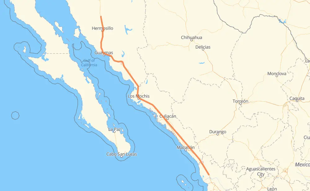
The distance from Guadalajara to Tijuanita is 1,194 kilometers by road including 1,094 kilometers on motorways. Road takes approximately 13 hours and 11 minutes and goes through Hermosillo, Navojoa, Los Mochis, Gabriel Leyva Solano and Dimas (Estación Dimas).
How much does it cost to drive from Guadalajara to Tijuanita?
Fuel cost:
141.4 GBP
This fuel cost is calculated as: (Route length 1,194 km / 100 km) * (Fuel consumption 8 L/100 km) * (Fuel price 1.48 GBP / L)
You can adjust fuel consumption and fuel price here.
Toll roads cost:
1,064 + ? MXN
How long is a car ride from Guadalajara to Tijuanita?
Driving time:
13 h 11 min
This time is calculated for driving at the maximum permitted speed, taking into account traffic rules restrictions.
240 km with a maximum speed 110 km/h = 2 h 10 min
370 km with a maximum speed 100 km/h = 3 h 42 min
17 km with a maximum speed 96 km/h = 10 min
97 km with a maximum speed 90 km/h = 1 h 4 min
452 km with a maximum speed 80 km/h = 5 h 38 min
14 km with a maximum speed 60 km/h = 13 min
4 km with a maximum speed 50 km/h = 4 min
1 km with a maximum speed 10 km/h = 6 min
The calculated driving time does not take into account intermediate stops and traffic jams.
How far is Guadalajara to Tijuanita by land?
The distance between Guadalajara and Tijuanita is 1,194 km by road including 1,094 km on motorways.
Precise satellite coordinates of highways were used for this calculation. The start and finish points are the centers of Guadalajara and Tijuanita respectively.
How far is Guadalajara to Tijuanita by plane?
The shortest distance (air line, as the crow flies) between Guadalajara and Tijuanita is 1,050 km.
This distance is calculated using the Haversine formula as a great-circle distance between two points on the surface of a sphere. The start and finish points are the centers of Guadalajara and Tijuanita respectively. Actual distance between airports may be different.
How many hours is Guadalajara from Tijuanita by plane?
Boeing 737 airliner needs 1 h 18 min to cover the distance of 1,050 km at a cruising speed of 800 km/h.
Small plane "Cessna 172" needs 4 h 46 min to flight this distance at average speed of 220 km/h.
This time is approximate and do not take into account takeoff and landing times, airport location and other real world factors.
How long is a helicopter ride from Guadalajara to Tijuanita?
Fast helicopter "Eurocopter AS350" or "Hughes OH-6 Cayuse" need 4 h 22 min to cover the distance of 1,050 km at a cruising speed of 240 km/h.
Popular "Robinson R44" needs 5 h to flight this distance at average speed of 210 km/h.
This time is approximate and do not take into account takeoff and landing times, aerodrome location and other real world factors.
What city is halfway between Guadalajara and Tijuanita?
The halfway point between Guadalajara and Tijuanita is Juan José Ríos. It is located about 4 km from the exact midpoint by road.
The distance from Juan José Ríos to Guadalajara is 601 km and driving will take about 6 h 36 min. The road between Juan José Ríos and Tijuanita has length 593 km and will take approximately 6 h 34 min.
The other cities located close to halfway point:
Guayparime is in 605 km from Guadalajara and 589 km from Tijuanita
Adolfo Ruiz Cortines is in 610 km from Guadalajara and 584 km from Tijuanita
Los Mochis is in 583 km from Guadalajara and 611 km from Tijuanita
Where is Guadalajara in relation to Tijuanita?
Guadalajara is located 1,050 km north-west of Tijuanita.
Guadalajara has geographic coordinates: latitude 29.75767, longitude -111.05267.
Tijuanita has geographic coordinates: latitude 21.95581, longitude -105.1299.
Which highway goes from Guadalajara to Tijuanita?
The route from Guadalajara to Tijuanita follows MEX 15D.