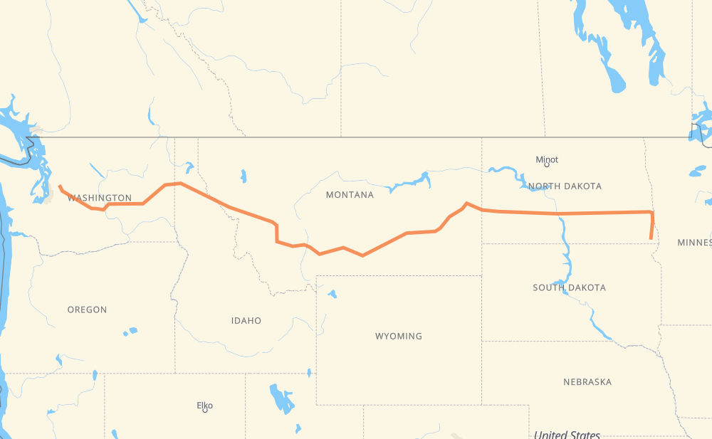
The distance from Hankinson to Carnation is 2,360 kilometers by road including 2,330 kilometers on motorways. Road takes approximately 21 hours and 55 minutes and goes through Fargo, West Fargo, Bismarck, Mandan, Dickinson, Billings and Butte.
How much does it cost to drive from Hankinson to Carnation?
Fuel cost:
281.4 GBP
This fuel cost is calculated as: (Route length 2,360 km / 100 km) * (Fuel consumption 8 L/100 km) * (Fuel price 1.49 GBP / L)
You can adjust fuel consumption and fuel price here.
How long is a car ride from Hankinson to Carnation?
Driving time:
21 h 55 min
This time is calculated for driving at the maximum permitted speed, taking into account traffic rules restrictions.
1,782 km with a maximum speed 112 km/h = 15 h 54 min
143 km with a maximum speed 105 km/h = 1 h 22 min
286 km with a maximum speed 100 km/h = 2 h 51 min
46 km with a maximum speed 97 km/h = 28 min
3 km with a maximum speed 96 km/h = 1 min
24 km with a maximum speed 89 km/h = 16 min
2 km with a maximum speed 80 km/h = 1 min
63 km with a maximum speed 80 km/h = 47 min
4 km with a maximum speed 72 km/h = 3 min
1 km with a maximum speed 64 km/h = 1 min
4 km with a maximum speed 48 km/h = 4 min
The calculated driving time does not take into account intermediate stops and traffic jams.
How far is Hankinson to Carnation by land?
The distance between Hankinson and Carnation is 2,360 km by road including 2,330 km on motorways.
Precise satellite coordinates of highways were used for this calculation. The start and finish points are the centers of Hankinson and Carnation respectively.
How far is Hankinson to Carnation by plane?
The shortest distance (air line, as the crow flies) between Hankinson and Carnation is 1,902 km.
This distance is calculated using the Haversine formula as a great-circle distance between two points on the surface of a sphere. The start and finish points are the centers of Hankinson and Carnation respectively. Actual distance between airports may be different.
How many hours is Hankinson from Carnation by plane?
Boeing 737 airliner needs 2 h 22 min to cover the distance of 1,902 km at a cruising speed of 800 km/h.
Small plane "Cessna 172" needs 8 h 38 min to flight this distance at average speed of 220 km/h.
This time is approximate and do not take into account takeoff and landing times, airport location and other real world factors.
How long is a helicopter ride from Hankinson to Carnation?
Fast helicopter "Eurocopter AS350" or "Hughes OH-6 Cayuse" need 7 h 55 min to cover the distance of 1,902 km at a cruising speed of 240 km/h.
Popular "Robinson R44" needs 9 h 3 min to flight this distance at average speed of 210 km/h.
This time is approximate and do not take into account takeoff and landing times, aerodrome location and other real world factors.
What city is halfway between Hankinson and Carnation?
The halfway point between Hankinson and Carnation is Greycliff.
The distance from Greycliff to Hankinson is 1,180 km and driving will take about 11 h 6 min. The road between Greycliff and Carnation has length 1,181 km and will take approximately 10 h 48 min.
The other cities located close to halfway point:
Quebec is in 1,169 km from Hankinson and 1,192 km from Carnation
Big Timber is in 1,199 km from Hankinson and 1,162 km from Carnation
Reed Point is in 1,157 km from Hankinson and 1,204 km from Carnation
Where is Hankinson in relation to Carnation?
Hankinson is located 1,902 km east of Carnation.
Hankinson has geographic coordinates: latitude 46.06968, longitude -96.90175.
Carnation has geographic coordinates: latitude 47.64751, longitude -121.91294.
Which highway goes from Hankinson to Carnation?
The route from Hankinson to Carnation follows I 90, I 94, US 12, US 52.