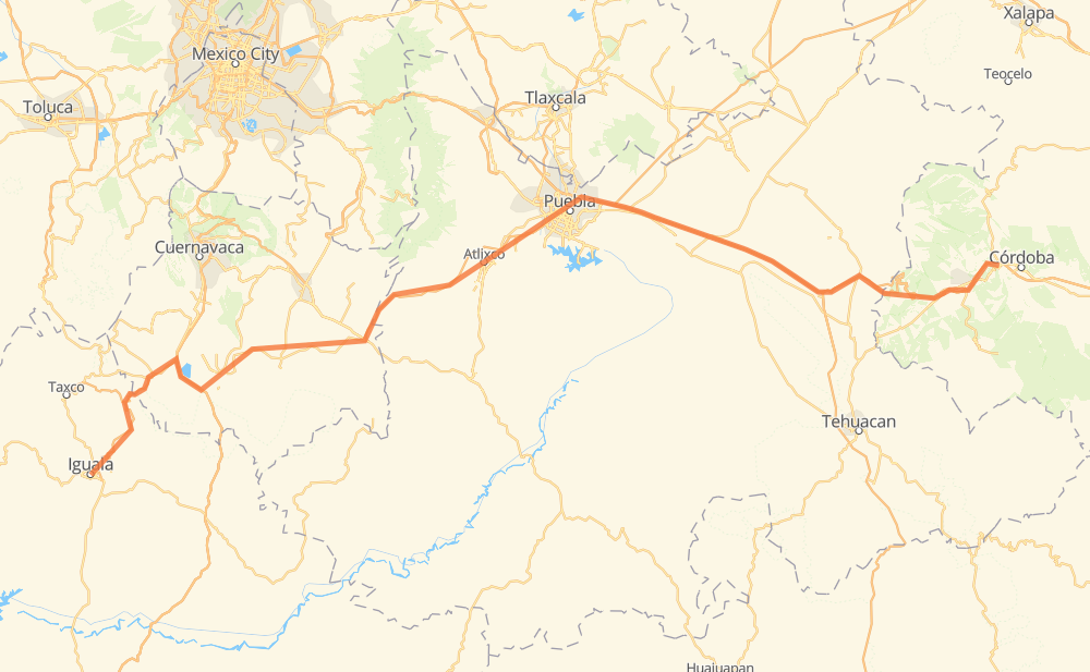
Distance between Iguala and Fortín de las Flores
The distance from Iguala to Fortín de las Flores is 378 kilometers by road including 299 kilometers on motorways. Road takes approximately 4 hours and 16 minutes and goes through Puebla, Orizaba, Puente de Ixtla, Acatzingo de Hidalgo, Palmarito Tochapan, Cuacnopalan and Maltrata.
| Shortest distance by air | 275 km ✈️ |
| Car route length | 378 km 🚗 |
| Driving time | 4 h 16 min |
| Fuel amount | 30.2 L |
| Fuel cost | 45 GBP |
| Toll roads cost | 300 + ? MXN |
| Point | Distance | Time | Fuel | |
| Iguala | 0 km | 00 min | 0.0 L | |
|
MEX 95 MEX 091D 61 km, 45 min
|
||||
| Puente de Ixtla | 61 km | 45 min | 4.6 L | |
|
MEX 091D PUE 438D 161 km, 1 h 41 min
|
||||
| Puebla | 222 km | 2 h 27 min | 17.4 L | |
|
MEX 190D MEX 150D 54 km, 34 min
|
||||
| Acatzingo de Hidalgo | 277 km | 3 h 01 min | 21.7 L | |
|
MEX 150D 14 km, 09 min
|
||||
| Palmarito Tochapan | 291 km | 3 h 10 min | 23.0 L | |
|
MEX 150D 13 km, 09 min
|
||||
| Cuacnopalan | 303 km | 3 h 19 min | 23.5 L | |
|
MEX 150D 31 km, 22 min
|
||||
| Maltrata | 334 km | 3 h 42 min | 26.6 L | |
|
MEX 150D 25 km, 18 min
|
||||
| Nogales | 359 km | 4 h 00 min | 28.5 L | |
|
MEX 150D 7 km, 05 min
|
||||
| Orizaba | 366 km | 4 h 05 min | 29.0 L | |
|
MEX 150D 15 km, 10 min
|
||||
| Fortín de las Flores | 381 km | 4 h 16 min | 30.4 L | |
Hotels of Fortín de las Flores
Frequently Asked Questions
How many toll booths are there from Iguala to Fortín de las Flores?
There are 7 toll booths between Iguala and Fortín de las Flores: Fortín, Iguala, Amozoc, Esperanza 27, Vía Atlixcayotl, Siglo XXI and Tlaltizapan.
How much does the toll booths cost from Iguala to Fortín de las Flores?
Toll roads cost: Iguala (88 MXN) + Tlaltizapan (?) + Siglo XXI (?) + Vía Atlixcayotl (?) + Amozoc (72 MXN) + Esperanza 27 (140 MXN) + Fortín (?) = 300 + ? MXN
How much does it cost to drive from Iguala to Fortín de las Flores?
Fuel cost: 45 GBP
This fuel cost is calculated as: (Route length 378 km / 100 km) * (Fuel consumption 8 L/100 km) * (Fuel price 1.49 GBP / L)
You can adjust fuel consumption and fuel price here.
Toll roads cost: 300 + ? MXN
How long is a car ride from Iguala to Fortín de las Flores?
Driving time: 4 h 16 min
This time is calculated for driving at the maximum permitted speed, taking into account traffic rules restrictions.
- 88 km with a maximum speed 110 km/h = 48 min
- 75 km with a maximum speed 100 km/h = 44 min
- 15 km with a maximum speed 96 km/h = 9 min
- 21 km with a maximum speed 90 km/h = 14 min
- 167 km with a maximum speed 80 km/h = 2 h 5 min
- 11 km with a maximum speed 70 km/h = 9 min
- 3 km with a maximum speed 50 km/h = 3 min
- 1 km with a maximum speed 40 km/h = 1 min
The calculated driving time does not take into account intermediate stops and traffic jams.
How far is Iguala to Fortín de las Flores by land?
The distance between Iguala and Fortín de las Flores is 378 km by road including 299 km on motorways.
Precise satellite coordinates of highways were used for this calculation. The start and finish points are the centers of Iguala and Fortín de las Flores respectively.
How far is Iguala to Fortín de las Flores by plane?
The shortest distance (air line, as the crow flies) between Iguala and Fortín de las Flores is 275 km.
This distance is calculated using the Haversine formula as a great-circle distance between two points on the surface of a sphere. The start and finish points are the centers of Iguala and Fortín de las Flores respectively. Actual distance between airports may be different.
How many hours is Iguala from Fortín de las Flores by plane?
Boeing 737 airliner needs 20 min to cover the distance of 275 km at a cruising speed of 800 km/h.
Small plane "Cessna 172" needs 1 h 15 min to flight this distance at average speed of 220 km/h.
This time is approximate and do not take into account takeoff and landing times, airport location and other real world factors.
How long is a helicopter ride from Iguala to Fortín de las Flores?
Fast helicopter "Eurocopter AS350" or "Hughes OH-6 Cayuse" need 1 h 8 min to cover the distance of 275 km at a cruising speed of 240 km/h.
Popular "Robinson R44" needs 1 h 18 min to flight this distance at average speed of 210 km/h.
This time is approximate and do not take into account takeoff and landing times, aerodrome location and other real world factors.
What city is halfway between Iguala and Fortín de las Flores?
The halfway point between Iguala and Fortín de las Flores is Metepec. It is located about 2 km from the exact midpoint by road.
The distance from Metepec to Iguala is 186 km and driving will take about 2 h 2 min. The road between Metepec and Fortín de las Flores has length 191 km and will take approximately 2 h 14 min.
The other cities located close to halfway point:
Where is Iguala in relation to Fortín de las Flores?
Iguala is located 275 km west of Fortín de las Flores.
Iguala has geographic coordinates: latitude 18.3438, longitude -99.53722.
Fortín de las Flores has geographic coordinates: latitude 18.89891, longitude -96.99814.
Which highway goes from Iguala to Fortín de las Flores?
The route from Iguala to Fortín de las Flores follows MEX 150D.
Other minor sections pass along the road:
- PUE 438D: 54 km
- MEX 091D: 43 km
- MEX 190D: 22 km
- MEX 91D: 20 km
- MEX 95D: 13 km
- MEX 95: 2 km