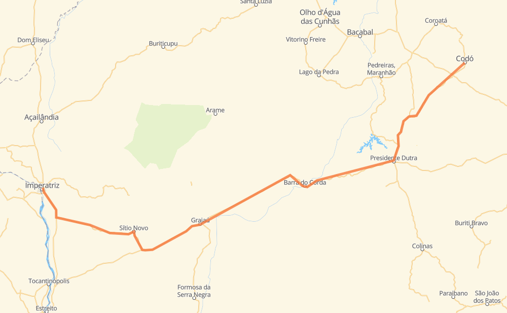
Distance between Imperatriz and Codó
The distance from Imperatriz to Codó is 536 kilometers by road. Road takes approximately 6 hours and 24 minutes and goes through Vila Davi, Bananal_, Ribeirãozinho da Roça, Novo Horizonte, Vale do Jordão, São José and Dois Buritis.
| Shortest distance by air | 415 km ✈️ |
| Car route length | 536 km 🚗 |
| Driving time | 6 h 24 min |
| Fuel amount | 42.9 L |
| Fuel cost | 63.9 GBP |
| Point | Distance | Time | Fuel | |
| Imperatriz | 0 km | 00 min | 0.0 L | |
|
BR-010 19 km, 13 min
|
||||
| Bananal_ | 19 km | 13 min | 0.7 L | |
|
BR-010 12 km, 08 min
|
||||
| Ribeirãozinho da Roça | 31 km | 21 min | 2.4 L | |
|
BR-010 13 km, 09 min
|
||||
| Novo Horizonte | 44 km | 31 min | 2.5 L | |
|
MA-280 16 km, 12 min
|
||||
| Vale do Jordão | 60 km | 44 min | 4.5 L | |
|
MA-280 28 km, 20 min
|
||||
| São José | 88 km | 1 h 04 min | 5.3 L | |
|
MA-280 71 km, 50 min
|
||||
| Gato Preto | 159 km | 1 h 55 min | 10.5 L | |
|
BR-226 98 km, 1 h 12 min
|
||||
| Aldeia Barreirinha | 257 km | 3 h 07 min | 16.8 L | |
|
BR-226 109 km, 1 h 19 min
|
||||
| Arara | 366 km | 4 h 27 min | 26.3 L | |
|
BR-226 BR-135 72 km, 50 min
|
||||
| Santa Luzia | 438 km | 5 h 17 min | 34.9 L | |
|
BR-135 MA-026 98 km, 1 h 07 min
|
||||
| -4.45562, -43.89235 | 536 km | 6 h 24 min | 42.9 L | |
Frequently Asked Questions
How much does it cost to drive from Imperatriz to Codó?
Fuel cost: 63.9 GBP
This fuel cost is calculated as: (Route length 536 km / 100 km) * (Fuel consumption 8 L/100 km) * (Fuel price 1.49 GBP / L)
You can adjust fuel consumption and fuel price here.
How long is a car ride from Imperatriz to Codó?
Driving time: 6 h 24 min
This time is calculated for driving at the maximum permitted speed, taking into account traffic rules restrictions.
- 140 km with a maximum speed 96 km/h = 1 h 27 min
- 396 km with a maximum speed 80 km/h = 4 h 57 min
The calculated driving time does not take into account intermediate stops and traffic jams.
How far is Imperatriz to Codó by land?
The distance between Imperatriz and Codó is 536 km by road.
Precise satellite coordinates of highways were used for this calculation. The start and finish points are the centers of Imperatriz and Codó respectively.
How far is Imperatriz to Codó by plane?
The shortest distance (air line, as the crow flies) between Imperatriz and Codó is 415 km.
This distance is calculated using the Haversine formula as a great-circle distance between two points on the surface of a sphere. The start and finish points are the centers of Imperatriz and Codó respectively. Actual distance between airports may be different.
How many hours is Imperatriz from Codó by plane?
Boeing 737 airliner needs 31 min to cover the distance of 415 km at a cruising speed of 800 km/h.
Small plane "Cessna 172" needs 1 h 53 min to flight this distance at average speed of 220 km/h.
This time is approximate and do not take into account takeoff and landing times, airport location and other real world factors.
How long is a helicopter ride from Imperatriz to Codó?
Fast helicopter "Eurocopter AS350" or "Hughes OH-6 Cayuse" need 1 h 43 min to cover the distance of 415 km at a cruising speed of 240 km/h.
Popular "Robinson R44" needs 1 h 58 min to flight this distance at average speed of 210 km/h.
This time is approximate and do not take into account takeoff and landing times, aerodrome location and other real world factors.
What city is halfway between Imperatriz and Codó?
The halfway point between Imperatriz and Codó is Aldeia Barreirinha. It is located about 12 km from the exact midpoint by road.
The distance from Aldeia Barreirinha to Imperatriz is 257 km and driving will take about 3 h 7 min. The road between Aldeia Barreirinha and Codó has length 280 km and will take approximately 3 h 16 min.
Where is Imperatriz in relation to Codó?
Imperatriz is located 415 km south-west of Codó.
Imperatriz has geographic coordinates: latitude -5.52693, longitude -47.47812.
Codó has geographic coordinates: latitude -4.45562, longitude -43.89235.
Which highway goes from Imperatriz to Codó?
The route from Imperatriz to Codó follows BR-226.
Other minor sections pass along the road:
- MA-280: 99 km
- MA-026: 81 km
- BR-135: 48 km
- BR-010: 30 km