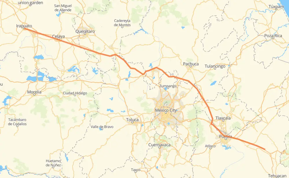
Distance between Irapuato and Santa Cruz Ocotlán
The distance from Irapuato to Santa Cruz Ocotlán is 496 kilometers by road including 488 kilometers on motorways. Road takes approximately 5 hours and 10 minutes and goes through Salamanca, Celaya, Cárdenas, Apaseo el Grande, Santa María Moyotzingo, San Miguel Xoxtla and San Francisco Ocotlán (Ocotlán).
| Shortest distance by air | 442 km ✈️ |
| Car route length | 496 km 🚗 |
| Driving time | 5 h 10 min |
| Fuel amount | 39.7 L |
| Fuel cost | 59.1 GBP |
| Toll roads cost | 286 + ? MXN |
| Point | Distance | Time | Fuel | |
| Irapuato | 0 km | 00 min | 0.0 L | |
|
MEX 45D 14 km, 10 min
|
||||
| Cárdenas | 14 km | 10 min | 0.8 L | |
|
MEX 45D 8 km, 06 min
|
||||
| Salamanca | 22 km | 16 min | 1.4 L | |
|
MEX 45D 36 km, 22 min
|
||||
| Celaya | 58 km | 38 min | 4.3 L | |
|
MEX 45D 15 km, 08 min
|
||||
| Apaseo el Grande | 73 km | 47 min | 5.6 L | |
|
MEX 45D MEX M40D 325 km, 3 h 14 min
|
||||
| Santa María Moyotzingo | 397 km | 4 h 01 min | 31.6 L | |
|
MEX 150D 12 km, 07 min
|
||||
| San Miguel Xoxtla | 409 km | 4 h 09 min | 32.2 L | |
|
MEX 150D 8 km, 05 min
|
||||
| San Francisco Ocotlán (Ocotlán) | 417 km | 4 h 14 min | 33.3 L | |
|
MEX 150D 63 km, 40 min
|
||||
| Acatzingo de Hidalgo | 479 km | 4 h 55 min | 37.9 L | |
|
MEX 150D 20 km, 14 min
|
||||
| Santa Cruz Ocotlán | 499 km | 5 h 09 min | 39.9 L | |
Frequently Asked Questions
How many toll booths are there from Irapuato to Santa Cruz Ocotlán?
There are 9 toll booths between Irapuato and Santa Cruz Ocotlán: Salamanca, Cerro Gordo, Queretaro, Palmillas, Palmilas - Apaseo, San Martin Texmelucan, San Martín, Viaducto Elevado de Puebla and Amozoc.
How much does the toll booths cost from Irapuato to Santa Cruz Ocotlán?
Toll roads cost: Salamanca (83 MXN) + Cerro Gordo (?) + Palmilas - Apaseo (?) + Palmillas (89 MXN) + Queretaro (?) + San Martin Texmelucan (?) + San Martín (42 MXN) + Viaducto Elevado de Puebla (?) + Amozoc (72 MXN) = 286 + ? MXN
How much does it cost to drive from Irapuato to Santa Cruz Ocotlán?
Fuel cost: 59.1 GBP
This fuel cost is calculated as: (Route length 496 km / 100 km) * (Fuel consumption 8 L/100 km) * (Fuel price 1.49 GBP / L)
You can adjust fuel consumption and fuel price here.
Toll roads cost: 286 + ? MXN
How long is a car ride from Irapuato to Santa Cruz Ocotlán?
Driving time: 5 h 10 min
This time is calculated for driving at the maximum permitted speed, taking into account traffic rules restrictions.
- 155 km with a maximum speed 110 km/h = 1 h 24 min
- 227 km with a maximum speed 100 km/h = 2 h 16 min
- 27 km with a maximum speed 90 km/h = 18 min
- 78 km with a maximum speed 80 km/h = 58 min
- 5 km with a maximum speed 70 km/h = 3 min
- 5 km with a maximum speed 50 km/h = 6 min
- 1 km with a maximum speed 40 km/h = 1 min
The calculated driving time does not take into account intermediate stops and traffic jams.
How far is Irapuato to Santa Cruz Ocotlán by land?
The distance between Irapuato and Santa Cruz Ocotlán is 496 km by road including 488 km on motorways.
Precise satellite coordinates of highways were used for this calculation. The start and finish points are the centers of Irapuato and Santa Cruz Ocotlán respectively.
How far is Irapuato to Santa Cruz Ocotlán by plane?
The shortest distance (air line, as the crow flies) between Irapuato and Santa Cruz Ocotlán is 442 km.
This distance is calculated using the Haversine formula as a great-circle distance between two points on the surface of a sphere. The start and finish points are the centers of Irapuato and Santa Cruz Ocotlán respectively. Actual distance between airports may be different.
How many hours is Irapuato from Santa Cruz Ocotlán by plane?
Boeing 737 airliner needs 33 min to cover the distance of 442 km at a cruising speed of 800 km/h.
Small plane "Cessna 172" needs 2 h to flight this distance at average speed of 220 km/h.
This time is approximate and do not take into account takeoff and landing times, airport location and other real world factors.
How long is a helicopter ride from Irapuato to Santa Cruz Ocotlán?
Fast helicopter "Eurocopter AS350" or "Hughes OH-6 Cayuse" need 1 h 50 min to cover the distance of 442 km at a cruising speed of 240 km/h.
Popular "Robinson R44" needs 2 h 6 min to flight this distance at average speed of 210 km/h.
This time is approximate and do not take into account takeoff and landing times, aerodrome location and other real world factors.
What city is halfway between Irapuato and Santa Cruz Ocotlán?
The halfway point between Irapuato and Santa Cruz Ocotlán is Tezoquipa. It is located about 11 km from the exact midpoint by road.
The distance from Tezoquipa to Irapuato is 258 km and driving will take about 2 h 34 min. The road between Tezoquipa and Santa Cruz Ocotlán has length 237 km and will take approximately 2 h 35 min.
The other cities located close to halfway point:
Where is Irapuato in relation to Santa Cruz Ocotlán?
Irapuato is located 442 km north-west of Santa Cruz Ocotlán.
Irapuato has geographic coordinates: latitude 20.67588, longitude -101.35211.
Santa Cruz Ocotlán has geographic coordinates: latitude 18.88278, longitude -97.58278.
Which highway goes from Irapuato to Santa Cruz Ocotlán?
The route from Irapuato to Santa Cruz Ocotlán follows MEX M40D.
Other minor sections pass along the road:
- MEX 150D: 99 km
- MEX 47D: 83 km
- MEX 45D: 71 km
- MEX 57D: 57 km