Distance between Jiménez and El Porvenir
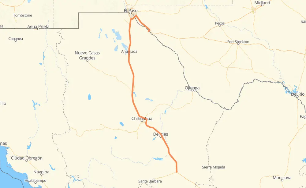
The distance from Jiménez to El Porvenir is 673 kilometers by road including 191 kilometers on motorways. Road takes approximately 7 hours and 12 minutes and goes through Camargo, Delicias, Ciudad Juárez, Conchos, Estación Saucillo, Lazaro Cardenas and Villa Ahumada.
| Shortest distance by air | 466 km ✈️ |
| Car route length | 673 km 🚗 |
| Driving time | 7 h 12 min |
| Fuel amount | 53.9 L |
| Fuel cost | 79.7 GBP |
| Toll roads cost | 600 MXN |
| Point | Distance | Time | Fuel | |
| Jiménez | 0 km | 00 min | 0.0 L | |
|
MEX 45D 71 km, 45 min
|
||||
| Camargo | 71 km | 45 min | 5.3 L | |
|
MEX 45 MEX 45D 33 km, 19 min
|
||||
| Conchos | 104 km | 1 h 04 min | 7.9 L | |
|
MEX 45D 10 km, 05 min
|
||||
| Estación Saucillo | 114 km | 1 h 10 min | 8.8 L | |
|
MEX 45D 25 km, 17 min
|
||||
| Delicias | 140 km | 1 h 27 min | 10.7 L | |
|
MEX 45 23 km, 15 min
|
||||
| Lazaro Cardenas | 163 km | 1 h 42 min | 12.4 L | |
|
MEX 45 306 km, 3 h 14 min
|
||||
| Villa Ahumada | 468 km | 4 h 57 min | 36.9 L | |
|
MEX 45 120 km, 1 h 22 min
|
||||
| Ciudad Juárez | 588 km | 6 h 20 min | 46.7 L | |
|
Loop 375 20 km, 12 min
|
||||
| Socorro | 608 km | 6 h 32 min | 48.5 L | |
|
I 10 65 km, 39 min
|
||||
| El Porvenir | 673 km | 7 h 12 min | 53.5 L | |
Frequently Asked Questions
How many toll booths are there from Jiménez to El Porvenir?
There are 8 toll booths between Jiménez and El Porvenir: Zaragoza-Ysleta, Villa Ahumada, Sacramento, Libramiento Oriente de Chihuahua - Sacramento, Libramiento Oriente de Chihuahua - Jimenez, Saucillo, Camargo and Jimenez.
How much does the toll booths cost from Jiménez to El Porvenir?
Toll roads cost: Jimenez (97 MXN) + Camargo (71 MXN) + Saucillo (71 MXN) + Libramiento Oriente de Chihuahua - Jimenez (35 MXN) + Libramiento Oriente de Chihuahua - Sacramento (36 MXN) + Sacramento (71 MXN) + Villa Ahumada (188 MXN) + Zaragoza-Ysleta (31 MXN) = 600 MXN
How much does it cost to drive from Jiménez to El Porvenir?
Fuel cost: 79.7 GBP
This fuel cost is calculated as: (Route length 673 km / 100 km) * (Fuel consumption 8 L/100 km) * (Fuel price 1.48 GBP / L)
You can adjust fuel consumption and fuel price here.
Toll roads cost: 600 MXN
How long is a car ride from Jiménez to El Porvenir?
Driving time: 7 h 12 min
This time is calculated for driving at the maximum permitted speed, taking into account traffic rules restrictions.
- 57 km with a maximum speed 112 km/h = 30 min
- 36 km with a maximum speed 110 km/h = 19 min
- 77 km with a maximum speed 100 km/h = 46 min
- 3 km with a maximum speed 97 km/h = 2 min
- 260 km with a maximum speed 96 km/h = 2 h 42 min
- 192 km with a maximum speed 90 km/h = 2 h 8 min
- 26 km with a maximum speed 80 km/h = 19 min
- 4 km with a maximum speed 70 km/h = 3 min
- 9 km with a maximum speed 60 km/h = 9 min
- 3 km with a maximum speed 50 km/h = 4 min
- 5 km with a maximum speed 40 km/h = 6 min
The calculated driving time does not take into account intermediate stops and traffic jams.
How far is Jiménez to El Porvenir by land?
The distance between Jiménez and El Porvenir is 673 km by road including 191 km on motorways.
Precise satellite coordinates of highways were used for this calculation. The start and finish points are the centers of Jiménez and El Porvenir respectively.
How far is Jiménez to El Porvenir by plane?
The shortest distance (air line, as the crow flies) between Jiménez and El Porvenir is 466 km.
This distance is calculated using the Haversine formula as a great-circle distance between two points on the surface of a sphere. The start and finish points are the centers of Jiménez and El Porvenir respectively. Actual distance between airports may be different.
How many hours is Jiménez from El Porvenir by plane?
Boeing 737 airliner needs 34 min to cover the distance of 466 km at a cruising speed of 800 km/h.
Small plane "Cessna 172" needs 2 h 7 min to flight this distance at average speed of 220 km/h.
This time is approximate and do not take into account takeoff and landing times, airport location and other real world factors.
How long is a helicopter ride from Jiménez to El Porvenir?
Fast helicopter "Eurocopter AS350" or "Hughes OH-6 Cayuse" need 1 h 56 min to cover the distance of 466 km at a cruising speed of 240 km/h.
Popular "Robinson R44" needs 2 h 13 min to flight this distance at average speed of 210 km/h.
This time is approximate and do not take into account takeoff and landing times, aerodrome location and other real world factors.
What city is halfway between Jiménez and El Porvenir?
The halfway point between Jiménez and El Porvenir is Los Encinos. It is located about 29 km from the exact midpoint by road.
The distance from Los Encinos to Jiménez is 308 km and driving will take about 3 h 16 min. The road between Los Encinos and El Porvenir has length 365 km and will take approximately 3 h 56 min.
The other cities located close to halfway point:
Where is Jiménez in relation to El Porvenir?
Jiménez is located 466 km south of El Porvenir.
Jiménez has geographic coordinates: latitude 27.13086, longitude -104.9141.
El Porvenir has geographic coordinates: latitude 31.23875, longitude -105.87956.
Which highway goes from Jiménez to El Porvenir?
The route from Jiménez to El Porvenir follows MEX 45, MEX 45D.
Other minor sections pass along the road:
- I 10: 60 km
- MEX 2: 8 km
- Loop 375: 4 km
- MEX 49: 2 km
- Spur 148: 2 km
- TX 20: 1 km
- FM 1088: 1 km