Distance between Jiménez and Ojo de Agua
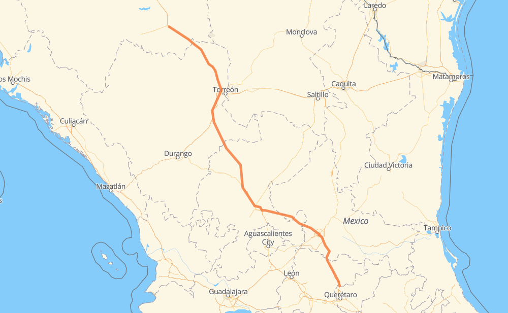
The distance from Jiménez to Ojo de Agua is 965 kilometers by road including 486 kilometers on motorways. Road takes approximately 10 hours and 8 minutes and goes through Fresnillo, Guadalupe, San Luis Potosi, Bermejillo, La Lomas, Cuencamé and Río Grande.
| Shortest distance by air | 831 km ✈️ |
| Car route length | 965 km 🚗 |
| Driving time | 10 h 8 min |
| Fuel amount | 77.2 L |
| Fuel cost | 115.1 GBP |
| Toll roads cost | 454 + ? MXN |
| Point | Distance | Time | Fuel | |
| Jiménez | 0 km | 00 min | 0.0 L | |
|
MEX 49 MEX 49D 180 km, 1 h 49 min
|
||||
| Bermejillo | 180 km | 1 h 49 min | 12.3 L | |
|
MEX 49D MEX 49 83 km, 51 min
|
||||
| La Lomas | 262 km | 2 h 41 min | 20.2 L | |
|
MEX 40D 68 km, 38 min
|
||||
| Cuencamé | 331 km | 3 h 20 min | 26.2 L | |
|
MEX 49 140 km, 1 h 27 min
|
||||
| Río Grande | 470 km | 4 h 47 min | 37.1 L | |
|
MEX 49 80 km, 49 min
|
||||
| Fresnillo | 550 km | 5 h 36 min | 43.2 L | |
|
MEX 45D MEX 45 33 km, 19 min
|
||||
| Víctor Rosales | 583 km | 5 h 56 min | 46.2 L | |
|
MEX 45D MEX 45 18 km, 11 min
|
||||
| Hacienda Nueva | 601 km | 6 h 08 min | 47.8 L | |
|
MEX 45D MEX 49 195 km, 2 h 09 min
|
||||
| San Luis Potosi | 795 km | 8 h 18 min | 63.1 L | |
|
MEX 57 170 km, 1 h 50 min
|
||||
| Ojo de Agua | 965 km | 10 h 08 min | 70.1 L | |
Frequently Asked Questions
How many toll booths are there from Jiménez to Ojo de Agua?
There are 8 toll booths between Jiménez and Ojo de Agua: Savalza, León Guzmán, Ceballos, Bermejillo, Cuencame, Morfín Chávez, Calera and Veta Grande.
How much does the toll booths cost from Jiménez to Ojo de Agua?
Toll roads cost: Savalza (71 MXN) + Ceballos (145 MXN) + Bermejillo (127 MXN) + León Guzmán (?) + Cuencame (?) + Morfín Chávez (40 MXN) + Calera (23 MXN) + Veta Grande (48 MXN) = 454 + ? MXN
How much does it cost to drive from Jiménez to Ojo de Agua?
Fuel cost: 115.1 GBP
This fuel cost is calculated as: (Route length 965 km / 100 km) * (Fuel consumption 8 L/100 km) * (Fuel price 1.49 GBP / L)
You can adjust fuel consumption and fuel price here.
Toll roads cost: 454 + ? MXN
How long is a car ride from Jiménez to Ojo de Agua?
Driving time: 10 h 8 min
This time is calculated for driving at the maximum permitted speed, taking into account traffic rules restrictions.
- 88 km with a maximum speed 112 km/h = 47 min
- 31 km with a maximum speed 110 km/h = 16 min
- 304 km with a maximum speed 100 km/h = 3 h 2 min
- 297 km with a maximum speed 96 km/h = 3 h 5 min
- 147 km with a maximum speed 90 km/h = 1 h 38 min
- 85 km with a maximum speed 80 km/h = 1 h 3 min
- 9 km with a maximum speed 60 km/h = 9 min
- 2 km with a maximum speed 50 km/h = 2 min
- 1 km with a maximum speed 40 km/h = 1 min
- 1 km with a maximum speed 30 km/h = 1 min
The calculated driving time does not take into account intermediate stops and traffic jams.
How far is Jiménez to Ojo de Agua by land?
The distance between Jiménez and Ojo de Agua is 965 km by road including 486 km on motorways.
Precise satellite coordinates of highways were used for this calculation. The start and finish points are the centers of Jiménez and Ojo de Agua respectively.
How far is Jiménez to Ojo de Agua by plane?
The shortest distance (air line, as the crow flies) between Jiménez and Ojo de Agua is 831 km.
This distance is calculated using the Haversine formula as a great-circle distance between two points on the surface of a sphere. The start and finish points are the centers of Jiménez and Ojo de Agua respectively. Actual distance between airports may be different.
How many hours is Jiménez from Ojo de Agua by plane?
Boeing 737 airliner needs 1 h 2 min to cover the distance of 831 km at a cruising speed of 800 km/h.
Small plane "Cessna 172" needs 3 h 46 min to flight this distance at average speed of 220 km/h.
This time is approximate and do not take into account takeoff and landing times, airport location and other real world factors.
How long is a helicopter ride from Jiménez to Ojo de Agua?
Fast helicopter "Eurocopter AS350" or "Hughes OH-6 Cayuse" need 3 h 27 min to cover the distance of 831 km at a cruising speed of 240 km/h.
Popular "Robinson R44" needs 3 h 57 min to flight this distance at average speed of 210 km/h.
This time is approximate and do not take into account takeoff and landing times, aerodrome location and other real world factors.
What city is halfway between Jiménez and Ojo de Agua?
The halfway point between Jiménez and Ojo de Agua is Río Grande. It is located about 12 km from the exact midpoint by road.
The distance from Río Grande to Jiménez is 470 km and driving will take about 4 h 47 min. The road between Río Grande and Ojo de Agua has length 495 km and will take approximately 5 h 21 min.
The other cities located close to halfway point:
Where is Jiménez in relation to Ojo de Agua?
Jiménez is located 831 km north-west of Ojo de Agua.
Jiménez has geographic coordinates: latitude 27.13086, longitude -104.9141.
Ojo de Agua has geographic coordinates: latitude 20.88484, longitude -100.41411.
Which highway goes from Jiménez to Ojo de Agua?
The route from Jiménez to Ojo de Agua follows MEX 49, MEX 49D, MEX 57.
Other minor sections pass along the road:
- MEX 40D: 85 km
- MEX 45D: 56 km
- MEX 45: 44 km
- MEX 40: 9 km
- MEX 40D:MEX 49D: 3 km
- MEX 80: 2 km
- MEX 54: 1 km