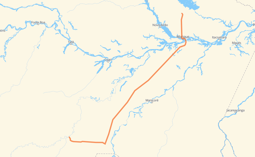
Distance between Lábrea and Presidente Figueiredo
The distance from Lábrea to Presidente Figueiredo is 979 kilometers by road. Road takes approximately 12 hours and 4 minutes and goes through Manaus, Betânia, Adrianópolis, Chapada and Colonia Terra Nova.
| Shortest distance by air | 785 km ✈️ |
| Car route length | 979 km 🚗 |
| Driving time | 12 h 4 min |
| Fuel amount | 78.3 L |
| Fuel cost | 116.7 GBP |
| Point | Distance | Time | Fuel | |
| -7.26137, -64.79245 | 0 km | 00 min | 0.0 L | |
|
BR-230 61 km, 40 min
|
||||
| Apartir de Labrea | 61 km | 40 min | 7.5 L | |
|
BR-230 65 km, 48 min
|
||||
| Nossa Senhora do Carmo | 126 km | 1 h 28 min | 9.8 L | |
|
BR-230 55 km, 41 min
|
||||
| Comunidade Maria Auxiliadora - Ipixuna | 181 km | 2 h 10 min | 17.8 L | |
|
BR-230 BR-319 415 km, 5 h 11 min
|
||||
| Igapó Açu | 595 km | 7 h 21 min | 48.8 L | |
|
BR-319 251 km, 3 h 09 min
|
||||
| Manaus | 847 km | 10 h 30 min | 71.3 L | |
|
2 km, 01 min
|
||||
| Betânia | 849 km | 10 h 32 min | 71.6 L | |
|
3 km, 02 min
|
||||
| Adrianópolis | 852 km | 10 h 34 min | 71.9 L | |
|
BR-174 4 km, 02 min
|
||||
| Chapada | 856 km | 10 h 37 min | 72.1 L | |
|
BR-174 8 km, 06 min
|
||||
| Colonia Terra Nova | 865 km | 10 h 43 min | 72.8 L | |
|
BR-174 44 km, 30 min
|
||||
| Novo Canaã | 909 km | 11 h 14 min | 75.9 L | |
|
BR-174 70 km, 50 min
|
||||
| -2.04864, -60.02367 | 979 km | 12 h 04 min | 82.0 L | |
Frequently Asked Questions
How much does it cost to drive from Lábrea to Presidente Figueiredo?
Fuel cost: 116.7 GBP
This fuel cost is calculated as: (Route length 979 km / 100 km) * (Fuel consumption 8 L/100 km) * (Fuel price 1.49 GBP / L)
You can adjust fuel consumption and fuel price here.
How long is a car ride from Lábrea to Presidente Figueiredo?
Driving time: 12 h 4 min
This time is calculated for driving at the maximum permitted speed, taking into account traffic rules restrictions.
- 307 km with a maximum speed 96 km/h = 3 h 11 min
- 651 km with a maximum speed 80 km/h = 8 h 8 min
- 8 km with a maximum speed 60 km/h = 8 min
- 12 km with a maximum speed 20 km/h = 35 min
The calculated driving time does not take into account intermediate stops and traffic jams.
How far is Lábrea to Presidente Figueiredo by land?
The distance between Lábrea and Presidente Figueiredo is 979 km by road.
Precise satellite coordinates of highways were used for this calculation. The start and finish points are the centers of Lábrea and Presidente Figueiredo respectively.
How far is Lábrea to Presidente Figueiredo by plane?
The shortest distance (air line, as the crow flies) between Lábrea and Presidente Figueiredo is 785 km.
This distance is calculated using the Haversine formula as a great-circle distance between two points on the surface of a sphere. The start and finish points are the centers of Lábrea and Presidente Figueiredo respectively. Actual distance between airports may be different.
How many hours is Lábrea from Presidente Figueiredo by plane?
Boeing 737 airliner needs 58 min to cover the distance of 785 km at a cruising speed of 800 km/h.
Small plane "Cessna 172" needs 3 h 34 min to flight this distance at average speed of 220 km/h.
This time is approximate and do not take into account takeoff and landing times, airport location and other real world factors.
How long is a helicopter ride from Lábrea to Presidente Figueiredo?
Fast helicopter "Eurocopter AS350" or "Hughes OH-6 Cayuse" need 3 h 16 min to cover the distance of 785 km at a cruising speed of 240 km/h.
Popular "Robinson R44" needs 3 h 44 min to flight this distance at average speed of 210 km/h.
This time is approximate and do not take into account takeoff and landing times, aerodrome location and other real world factors.
What city is halfway between Lábrea and Presidente Figueiredo?
The halfway point between Lábrea and Presidente Figueiredo is Igapó Açu. It is located about 106 km from the exact midpoint by road.
The distance from Igapó Açu to Lábrea is 595 km and driving will take about 7 h 21 min. The road between Igapó Açu and Presidente Figueiredo has length 383 km and will take approximately 4 h 43 min.
Where is Lábrea in relation to Presidente Figueiredo?
Lábrea is located 785 km south-west of Presidente Figueiredo.
Lábrea has geographic coordinates: latitude -7.26137, longitude -64.79245.
Presidente Figueiredo has geographic coordinates: latitude -2.04864, longitude -60.02367.
Which highway goes from Lábrea to Presidente Figueiredo?
The route from Lábrea to Presidente Figueiredo follows BR-319, BR-230, BR-174.