Distance between Lázaro Cárdenas and Tula de Allende
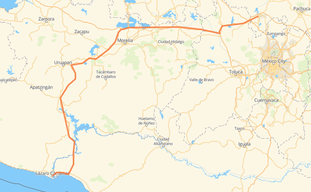
The distance from Lázaro Cárdenas to Tula de Allende is 547 kilometers by road including 369 kilometers on motorways. Road takes approximately 5 hours and 48 minutes and goes through Nueva Italia de Ruíz, Ziracuaretiro, Pátzcuaro, Maravatio, Pastores and Jilotepec de Molina Enriquez.
| Shortest distance by air | 380 km ✈️ |
| Car route length | 547 km 🚗 |
| Driving time | 5 h 48 min |
| Fuel amount | 43.8 L |
| Fuel cost | 65.2 GBP |
| Toll roads cost | 226 + ? MXN |
| Point | Distance | Time | Fuel | |
| Lázaro Cárdenas | 0 km | 00 min | 0.0 L | |
|
MEX 37D 15 km, 11 min
|
||||
| Surcua | 15 km | 11 min | 0.6 L | |
|
MEX 37D 52 km, 32 min
|
||||
| Infiernillo | 67 km | 44 min | 5.2 L | |
|
MEX 37D 37 km, 20 min
|
||||
| Las Cañas | 104 km | 1 h 05 min | 7.6 L | |
|
MEX 37D 59 km, 36 min
|
||||
| Nueva Italia de Ruíz | 162 km | 1 h 42 min | 12.8 L | |
|
MEX 37D 35 km, 21 min
|
||||
| Los Cajones | 197 km | 2 h 03 min | 15.2 L | |
|
MEX 37D 26 km, 16 min
|
||||
| Ziracuaretiro | 223 km | 2 h 20 min | 17.6 L | |
|
MEX 14D 34 km, 23 min
|
||||
| Pátzcuaro | 257 km | 2 h 43 min | 20.3 L | |
|
MEX 14D MEX 15D 148 km, 1 h 30 min
|
||||
| Maravatio | 406 km | 4 h 14 min | 32.1 L | |
|
MEX 15D 116 km, 1 h 16 min
|
||||
| Jilotepec de Molina Enriquez | 521 km | 5 h 30 min | 41.3 L | |
|
MEX M40D 26 km, 17 min
|
||||
| 20.05472, -99.34278 | 547 km | 5 h 48 min | 43.8 L | |
Hotels of Tula de Allende
Frequently Asked Questions
How many toll booths are there from Lázaro Cárdenas to Tula de Allende?
There are 14 toll booths between Lázaro Cárdenas and Tula de Allende: Feliciano, Las Cañas, Santa Casilda, Taretan, Zurumucapio, Zirahuen, Chapultepec km 58+100, Cuto, Zinapecuaro, Contepec, Tula 2, Atlacomulco — Maravatio, Atlacomulco 2 and Copandaro.
How much does the toll booths cost from Lázaro Cárdenas to Tula de Allende?
Toll roads cost: Feliciano (?) + Las Cañas (?) + Santa Casilda (?) + Taretan (?) + Zurumucapio (?) + Zirahuen (?) + Chapultepec km 58+100 (?) + Cuto (?) + Copandaro (15 MXN) + Zinapecuaro (161 MXN) + Contepec (?) + Atlacomulco — Maravatio (50 MXN) + Atlacomulco 2 (?) + Tula 2 (?) = 226 + ? MXN
How much does it cost to drive from Lázaro Cárdenas to Tula de Allende?
Fuel cost: 65.2 GBP
This fuel cost is calculated as: (Route length 547 km / 100 km) * (Fuel consumption 8 L/100 km) * (Fuel price 1.49 GBP / L)
You can adjust fuel consumption and fuel price here.
Toll roads cost: 226 + ? MXN
How long is a car ride from Lázaro Cárdenas to Tula de Allende?
Driving time: 5 h 48 min
This time is calculated for driving at the maximum permitted speed, taking into account traffic rules restrictions.
- 77 km with a maximum speed 110 km/h = 41 min
- 189 km with a maximum speed 100 km/h = 1 h 53 min
- 157 km with a maximum speed 96 km/h = 1 h 38 min
- 123 km with a maximum speed 80 km/h = 1 h 32 min
- 1 km with a maximum speed 50 km/h = 1 min
The calculated driving time does not take into account intermediate stops and traffic jams.
How far is Lázaro Cárdenas to Tula de Allende by land?
The distance between Lázaro Cárdenas and Tula de Allende is 547 km by road including 369 km on motorways.
Precise satellite coordinates of highways were used for this calculation. The start and finish points are the centers of Lázaro Cárdenas and Tula de Allende respectively.
How far is Lázaro Cárdenas to Tula de Allende by plane?
The shortest distance (air line, as the crow flies) between Lázaro Cárdenas and Tula de Allende is 380 km.
This distance is calculated using the Haversine formula as a great-circle distance between two points on the surface of a sphere. The start and finish points are the centers of Lázaro Cárdenas and Tula de Allende respectively. Actual distance between airports may be different.
How many hours is Lázaro Cárdenas from Tula de Allende by plane?
Boeing 737 airliner needs 28 min to cover the distance of 380 km at a cruising speed of 800 km/h.
Small plane "Cessna 172" needs 1 h 43 min to flight this distance at average speed of 220 km/h.
This time is approximate and do not take into account takeoff and landing times, airport location and other real world factors.
How long is a helicopter ride from Lázaro Cárdenas to Tula de Allende?
Fast helicopter "Eurocopter AS350" or "Hughes OH-6 Cayuse" need 1 h 35 min to cover the distance of 380 km at a cruising speed of 240 km/h.
Popular "Robinson R44" needs 1 h 48 min to flight this distance at average speed of 210 km/h.
This time is approximate and do not take into account takeoff and landing times, aerodrome location and other real world factors.
What city is halfway between Lázaro Cárdenas and Tula de Allende?
The halfway point between Lázaro Cárdenas and Tula de Allende is La Cadenita. It is located about 4 km from the exact midpoint by road.
The distance from La Cadenita to Lázaro Cárdenas is 269 km and driving will take about 2 h 51 min. The road between La Cadenita and Tula de Allende has length 278 km and will take approximately 2 h 56 min.
The other cities located close to halfway point:
Where is Lázaro Cárdenas in relation to Tula de Allende?
Lázaro Cárdenas is located 380 km south-west of Tula de Allende.
Lázaro Cárdenas has geographic coordinates: latitude 17.95948, longitude -102.19866.
Tula de Allende has geographic coordinates: latitude 20.05472, longitude -99.34278.
Which highway goes from Lázaro Cárdenas to Tula de Allende?
The route from Lázaro Cárdenas to Tula de Allende follows MEX 37D, MEX 15D.
Other minor sections pass along the road:
- MEX M40D: 63 km
- MEX 14D: 45 km
- MEX 040D: 6 km