Distance between Lake Station IN and Magog QC
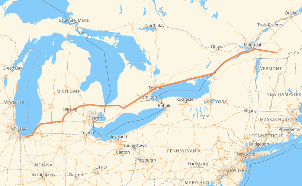
The distance from Lake Station to Magog is 1,432 kilometers by road including 1,415 kilometers on motorways. Road takes approximately 13 hours and 55 minutes and goes through Kalamazoo, Lansing, Flint, Sarnia, Woodstock, Kitchener and Mississauga.
| Shortest distance by air | 1,284 km ✈️ |
| Car route length | 1,432 km 🚗 |
| Driving time | 13 h 55 min |
| Fuel amount | 114.5 L |
| Fuel cost | 170.7 GBP |
| Point | Distance | Time | Fuel | |
| Lake Station | 0 km | 00 min | 0.0 L | |
|
US 6 I 94 175 km, 1 h 34 min
|
||||
| Kalamazoo | 175 km | 1 h 34 min | 13.9 L | |
|
I 94 I 69 104 km, 55 min
|
||||
| Lansing | 279 km | 2 h 30 min | 22.2 L | |
|
I 69 99 km, 53 min
|
||||
| Flint | 378 km | 3 h 23 min | 29.9 L | |
|
I 69 122 km, 1 h 14 min
|
||||
| Sarnia | 501 km | 4 h 38 min | 39.3 L | |
|
402 140 km, 1 h 19 min
|
||||
| Woodstock | 641 km | 5 h 57 min | 50.9 L | |
|
401 42 km, 25 min
|
||||
| Kitchener | 683 km | 6 h 23 min | 54.3 L | |
|
401 66 km, 39 min
|
||||
| Mississauga | 748 km | 7 h 02 min | 59.1 L | |
|
401 31 km, 18 min
|
||||
| Toronto | 780 km | 7 h 21 min | 60.7 L | |
|
401 32 km, 19 min
|
||||
| Ajax | 812 km | 7 h 40 min | 64.7 L | |
|
401 14 km, 08 min
|
||||
| Oshawa | 826 km | 7 h 48 min | 65.7 L | |
|
401 128 km, 1 h 16 min
|
||||
| Belleville | 953 km | 9 h 05 min | 75.7 L | |
|
401 75 km, 45 min
|
||||
| Kingston | 1,028 km | 9 h 50 min | 80.8 L | |
|
401 79 km, 47 min
|
||||
| Brockville | 1,107 km | 10 h 37 min | 88.0 L | |
|
401 92 km, 55 min
|
||||
| Cornwall | 1,199 km | 11 h 32 min | 95.6 L | |
|
401 10 233 km, 2 h 22 min
|
||||
| Magog | 1,432 km | 13 h 54 min | 114.3 L | |
Hotels of Magog
Frequently Asked Questions
How much does it cost to drive from Lake Station to Magog?
Fuel cost: 170.7 GBP
This fuel cost is calculated as: (Route length 1,432 km / 100 km) * (Fuel consumption 8 L/100 km) * (Fuel price 1.49 GBP / L)
You can adjust fuel consumption and fuel price here.
How long is a car ride from Lake Station to Magog?
Driving time: 13 h 55 min
This time is calculated for driving at the maximum permitted speed, taking into account traffic rules restrictions.
- 386 km with a maximum speed 112 km/h = 3 h 26 min
- 90 km with a maximum speed 110 km/h = 48 min
- 926 km with a maximum speed 100 km/h = 9 h 15 min
- 2 km with a maximum speed 96 km/h = 1 min
- 10 km with a maximum speed 90 km/h = 6 min
- 9 km with a maximum speed 80 km/h = 6 min
- 3 km with a maximum speed 70 km/h = 2 min
- 2 km with a maximum speed 65 km/h = 1 min
- 1 km with a maximum speed 50 km/h = 1 min
- 2 km with a maximum speed 40 km/h = 2 min
The calculated driving time does not take into account intermediate stops and traffic jams.
How far is Lake Station to Magog by land?
The distance between Lake Station and Magog is 1,432 km by road including 1,415 km on motorways.
Precise satellite coordinates of highways were used for this calculation. The start and finish points are the centers of Lake Station and Magog respectively.
How far is Lake Station to Magog by plane?
The shortest distance (air line, as the crow flies) between Lake Station and Magog is 1,284 km.
This distance is calculated using the Haversine formula as a great-circle distance between two points on the surface of a sphere. The start and finish points are the centers of Lake Station and Magog respectively. Actual distance between airports may be different.
How many hours is Lake Station from Magog by plane?
Boeing 737 airliner needs 1 h 36 min to cover the distance of 1,284 km at a cruising speed of 800 km/h.
Small plane "Cessna 172" needs 5 h 50 min to flight this distance at average speed of 220 km/h.
This time is approximate and do not take into account takeoff and landing times, airport location and other real world factors.
How long is a helicopter ride from Lake Station to Magog?
Fast helicopter "Eurocopter AS350" or "Hughes OH-6 Cayuse" need 5 h 21 min to cover the distance of 1,284 km at a cruising speed of 240 km/h.
Popular "Robinson R44" needs 6 h 6 min to flight this distance at average speed of 210 km/h.
This time is approximate and do not take into account takeoff and landing times, aerodrome location and other real world factors.
What city is halfway between Lake Station and Magog?
The halfway point between Lake Station and Magog is Morriston. It is located about 5 km from the exact midpoint by road.
The distance from Morriston to Lake Station is 710 km and driving will take about 6 h 39 min. The road between Morriston and Magog has length 721 km and will take approximately 7 h 16 min.
The other cities located close to halfway point:
Where is Lake Station in relation to Magog?
Lake Station is located 1,284 km west of Magog.
Lake Station has geographic coordinates: latitude 41.57504, longitude -87.23892.
Magog has geographic coordinates: latitude 45.26546, longitude -72.14791.
Which highway goes from Lake Station to Magog?
The route from Lake Station to Magog follows 401, I 69, I 94, 402, 10.
Other minor sections pass along the road:
- 30: 56 km
- 20: 18 km
- 338: 10 km
- I 96: 7 km
- 112: 5 km
- US 31: 5 km
- 201: 2 km