Distance between Lapinha and Serra
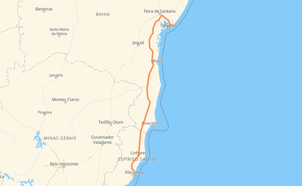
The distance from Lapinha to Serra is 1,140 kilometers by road including 88 kilometers on motorways. Road takes approximately 12 hours and 37 minutes and goes through Teixeira de Freitas, Dom Avelar, Ubaitaba, Aurelino Leal, Itamaraju, Vista Alegre and Cobraice.
| Shortest distance by air | 820 km ✈️ |
| Car route length | 1,140 km 🚗 |
| Driving time | 12 h 37 min |
| Fuel amount | 91.2 L |
| Fuel cost | 135 GBP |
| Point | Distance | Time | Fuel | |
| -12.95631, -38.49826 | 0 km | 00 min | 0.0 L | |
|
9 km, 05 min
|
||||
| Dom Avelar | 9 km | 05 min | 0.8 L | |
|
BR-324 BR-101 363 km, 4 h 07 min
|
||||
| Ubaitaba | 371 km | 4 h 12 min | 30.1 L | |
|
BR-101 9 km, 06 min
|
||||
| Aurelino Leal | 381 km | 4 h 19 min | 30.2 L | |
|
BR-101 353 km, 3 h 49 min
|
||||
| Itamaraju | 734 km | 8 h 09 min | 58.7 L | |
|
BR-101 71 km, 47 min
|
||||
| Teixeira de Freitas | 805 km | 8 h 56 min | 64.4 L | |
|
BR-101 90 km, 58 min
|
||||
| Vista Alegre | 894 km | 9 h 54 min | 71.6 L | |
|
BR-101 15 km, 11 min
|
||||
| Cobraice | 910 km | 10 h 06 min | 72.5 L | |
|
BR-101 36 km, 23 min
|
||||
| Litorâneo | 946 km | 10 h 29 min | 75.9 L | |
|
BR-101 61 km, 38 min
|
||||
| Vale do Sol | 1,007 km | 11 h 08 min | 80.7 L | |
|
BR-101 134 km, 1 h 28 min
|
||||
| Serra | 1,140 km | 12 h 37 min | 91.6 L | |
Hotels of Serra
Frequently Asked Questions
How much does it cost to drive from Lapinha to Serra?
Fuel cost: 135 GBP
This fuel cost is calculated as: (Route length 1,140 km / 100 km) * (Fuel consumption 8 L/100 km) * (Fuel price 1.48 GBP / L)
You can adjust fuel consumption and fuel price here.
How long is a car ride from Lapinha to Serra?
Driving time: 12 h 37 min
This time is calculated for driving at the maximum permitted speed, taking into account traffic rules restrictions.
- 88 km with a maximum speed 100 km/h = 52 min
- 718 km with a maximum speed 96 km/h = 7 h 28 min
- 319 km with a maximum speed 80 km/h = 3 h 59 min
- 13 km with a maximum speed 60 km/h = 13 min
- 2 km with a maximum speed 40 km/h = 2 min
The calculated driving time does not take into account intermediate stops and traffic jams.
How far is Lapinha to Serra by land?
The distance between Lapinha and Serra is 1,140 km by road including 88 km on motorways.
Precise satellite coordinates of highways were used for this calculation. The start and finish points are the centers of Lapinha and Serra respectively.
How far is Lapinha to Serra by plane?
The shortest distance (air line, as the crow flies) between Lapinha and Serra is 820 km.
This distance is calculated using the Haversine formula as a great-circle distance between two points on the surface of a sphere. The start and finish points are the centers of Lapinha and Serra respectively. Actual distance between airports may be different.
How many hours is Lapinha from Serra by plane?
Boeing 737 airliner needs 1 h 1 min to cover the distance of 820 km at a cruising speed of 800 km/h.
Small plane "Cessna 172" needs 3 h 43 min to flight this distance at average speed of 220 km/h.
This time is approximate and do not take into account takeoff and landing times, airport location and other real world factors.
How long is a helicopter ride from Lapinha to Serra?
Fast helicopter "Eurocopter AS350" or "Hughes OH-6 Cayuse" need 3 h 25 min to cover the distance of 820 km at a cruising speed of 240 km/h.
Popular "Robinson R44" needs 3 h 54 min to flight this distance at average speed of 210 km/h.
This time is approximate and do not take into account takeoff and landing times, aerodrome location and other real world factors.
What city is halfway between Lapinha and Serra?
The halfway point between Lapinha and Serra is Ventania. It is located about 12 km from the exact midpoint by road.
The distance from Ventania to Lapinha is 582 km and driving will take about 6 h 32 min. The road between Ventania and Serra has length 559 km and will take approximately 6 h 4 min.
The other cities located close to halfway point:
Where is Lapinha in relation to Serra?
Lapinha is located 820 km north of Serra.
Lapinha has geographic coordinates: latitude -12.95631, longitude -38.49826.
Serra has geographic coordinates: latitude -20.1253, longitude -40.30645.
Which highway goes from Lapinha to Serra?
The route from Lapinha to Serra follows BR-101.
Other minor sections pass along the road:
- BR-324: 88 km