Distance between Laranjal Paulista and São Simão
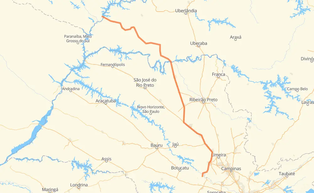
The distance from Laranjal Paulista to São Simão is 679 kilometers by road including 292 kilometers on motorways. Road takes approximately 7 hours and 25 minutes and goes through Piracicaba, Rio Claro, Conjunto Habitacional Pedro Zanella, Jardim Itamaraty, Jardim Araucária, Planura and Frutal.
| Shortest distance by air | 532 km ✈️ |
| Car route length | 679 km 🚗 |
| Driving time | 7 h 25 min |
| Fuel amount | 54.3 L |
| Fuel cost | 80.3 GBP |
| Point | Distance | Time | Fuel | |
| Conjunto Habitacional Pedro Zanella | 0 km | 00 min | 0.0 L | |
|
LRP-040 10 km, 09 min
|
||||
| Morro Vermelho | 10 km | 09 min | 0.5 L | |
|
LRP-335 9 km, 07 min
|
||||
| Conceição | 18 km | 17 min | 1.0 L | |
|
BR-373 34 km, 27 min
|
||||
| Piracicaba | 52 km | 44 min | 3.6 L | |
|
SP-127 37 km, 23 min
|
||||
| Rio Claro | 89 km | 1 h 07 min | 6.7 L | |
|
BR-364 SP-310 58 km, 35 min
|
||||
| Jardim Itamaraty | 147 km | 1 h 42 min | 11.7 L | |
|
SP-310 10 km, 06 min
|
||||
| Jardim Araucária | 157 km | 1 h 48 min | 12.4 L | |
|
SP-310 SP-326 231 km, 2 h 17 min
|
||||
| Planura | 388 km | 4 h 06 min | 30.7 L | |
|
BR-364 27 km, 17 min
|
||||
| Frutal | 415 km | 4 h 24 min | 32.9 L | |
|
BR-364 105 km, 1 h 06 min
|
||||
| Campina Verde | 520 km | 5 h 31 min | 41.4 L | |
|
BR-364 158 km, 1 h 54 min
|
||||
| -18.99350, -50.54704 | 679 km | 7 h 25 min | 54.3 L | |
Frequently Asked Questions
How much does it cost to drive from Laranjal Paulista to São Simão?
Fuel cost: 80.3 GBP
This fuel cost is calculated as: (Route length 679 km / 100 km) * (Fuel consumption 8 L/100 km) * (Fuel price 1.48 GBP / L)
You can adjust fuel consumption and fuel price here.
How long is a car ride from Laranjal Paulista to São Simão?
Driving time: 7 h 25 min
This time is calculated for driving at the maximum permitted speed, taking into account traffic rules restrictions.
- 4 km with a maximum speed 112 km/h = 2 min
- 162 km with a maximum speed 110 km/h = 1 h 28 min
- 98 km with a maximum speed 100 km/h = 58 min
- 217 km with a maximum speed 96 km/h = 2 h 15 min
- 9 km with a maximum speed 90 km/h = 5 min
- 166 km with a maximum speed 80 km/h = 2 h 4 min
- 9 km with a maximum speed 60 km/h = 9 min
- 14 km with a maximum speed 40 km/h = 20 min
The calculated driving time does not take into account intermediate stops and traffic jams.
How far is Laranjal Paulista to São Simão by land?
The distance between Laranjal Paulista and São Simão is 679 km by road including 292 km on motorways.
Precise satellite coordinates of highways were used for this calculation. The start and finish points are the centers of Laranjal Paulista and São Simão respectively.
How far is Laranjal Paulista to São Simão by plane?
The shortest distance (air line, as the crow flies) between Laranjal Paulista and São Simão is 532 km.
This distance is calculated using the Haversine formula as a great-circle distance between two points on the surface of a sphere. The start and finish points are the centers of Laranjal Paulista and São Simão respectively. Actual distance between airports may be different.
How many hours is Laranjal Paulista from São Simão by plane?
Boeing 737 airliner needs 39 min to cover the distance of 532 km at a cruising speed of 800 km/h.
Small plane "Cessna 172" needs 2 h 25 min to flight this distance at average speed of 220 km/h.
This time is approximate and do not take into account takeoff and landing times, airport location and other real world factors.
How long is a helicopter ride from Laranjal Paulista to São Simão?
Fast helicopter "Eurocopter AS350" or "Hughes OH-6 Cayuse" need 2 h 13 min to cover the distance of 532 km at a cruising speed of 240 km/h.
Popular "Robinson R44" needs 2 h 32 min to flight this distance at average speed of 210 km/h.
This time is approximate and do not take into account takeoff and landing times, aerodrome location and other real world factors.
What city is halfway between Laranjal Paulista and São Simão?
The halfway point between Laranjal Paulista and São Simão is Planura. It is located about 49 km from the exact midpoint by road.
The distance from Planura to Laranjal Paulista is 388 km and driving will take about 4 h 6 min. The road between Planura and São Simão has length 291 km and will take approximately 3 h 18 min.
The other cities located close to halfway point:
Where is Laranjal Paulista in relation to São Simão?
Laranjal Paulista is located 532 km south-east of São Simão.
Laranjal Paulista has geographic coordinates: latitude -23.05056, longitude -47.83755.
São Simão has geographic coordinates: latitude -18.9935, longitude -50.54704.
Which highway goes from Laranjal Paulista to São Simão?
The route from Laranjal Paulista to São Simão follows BR-364, SP-326, SP-310.
Other minor sections pass along the road:
- BR-267: 58 km
- SP-127: 53 km
- BR-373: 26 km
- BR-153: 25 km
- BR-262: 25 km
- BR-497: 10 km
- MG-497: 10 km
- BR-365: 8 km
- LRP-335: 6 km
- LRP-040: 2 km
- LRP-154: 2 km