Distance between Las Choapas and Papanoa
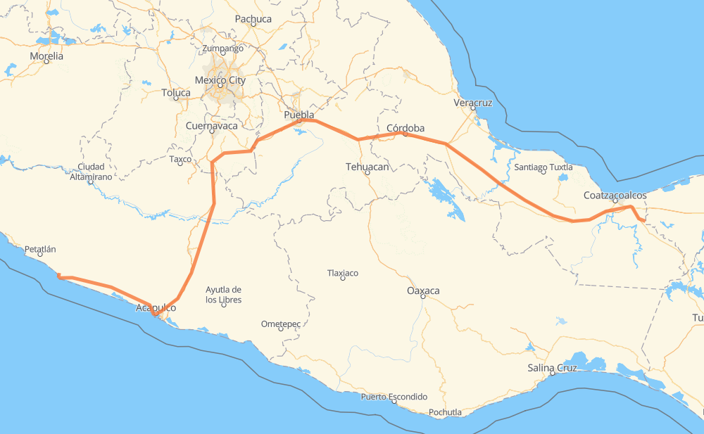
The distance from Las Choapas to Papanoa is 1,060 kilometers by road including 834 kilometers on motorways. Road takes approximately 11 hours and 33 minutes and goes through Orizaba, Puebla, Chilpancingo and Acapulco.
| Shortest distance by air | 739 km ✈️ |
| Car route length | 1,060 km 🚗 |
| Driving time | 11 h 33 min |
| Fuel amount | 84.8 L |
| Fuel cost | 126.4 GBP |
| Toll roads cost | 1,021 + ? MXN |
| Point | Distance | Time | Fuel | |
| Las Choapas | 0 km | 00 min | 0.0 L | |
|
MEX 145D 367 km, 3 h 46 min
|
||||
| Ixtaczoquitlán | 367 km | 3 h 46 min | 29.3 L | |
|
MEX 150D 5 km, 03 min
|
||||
| Orizaba | 372 km | 3 h 49 min | 29.4 L | |
|
MEX 150D 7 km, 05 min
|
||||
| Nogales | 379 km | 3 h 55 min | 30.1 L | |
|
MEX 150D 65 km, 48 min
|
||||
| Cuacnopalan | 444 km | 4 h 43 min | 34.8 L | |
|
MEX 150D 13 km, 09 min
|
||||
| Palmarito Tochapan | 457 km | 4 h 52 min | 36.3 L | |
|
MEX 150D 65 km, 42 min
|
||||
| Puebla | 521 km | 5 h 35 min | 41.3 L | |
|
MEX 95D 275 km, 2 h 57 min
|
||||
| Chilpancingo | 796 km | 8 h 32 min | 63.1 L | |
|
MEX 95D 108 km, 1 h 12 min
|
||||
| Acapulco | 904 km | 9 h 44 min | 72.0 L | |
|
MEX 95D MEX 200 156 km, 1 h 48 min
|
||||
| San Luis de la Loma | 1,060 km | 11 h 33 min | 82.6 L | |
Hotels of Papanoa
Frequently Asked Questions
How many toll booths are there from Las Choapas to Papanoa?
There are 16 toll booths between Las Choapas and Papanoa: Fortín, Cuitláhuac, Cosamaloapan, Acayucan, Antonio Dovali, Las Choapas, Tecpan, Maxitúnel Acapulco, La Venta, Palo Blanco, Paso Morelos, Amozoc, Esperanza 27, Vía Atlixcayotl, Siglo XXI and Tlaltizapan.
How much does the toll booths cost from Las Choapas to Papanoa?
Toll roads cost: Las Choapas (26 MXN) + Antonio Dovali (20 MXN) + Acayucan (?) + Cosamaloapan (229 MXN) + Cuitláhuac (114 MXN) + Fortín (33 MXN) + Esperanza 27 (140 MXN) + Amozoc (38 MXN) + Vía Atlixcayotl (?) + Siglo XXI (?) + Tlaltizapan (?) + Paso Morelos (154 MXN) + Palo Blanco (142 MXN) + La Venta (125 MXN) + Maxitúnel Acapulco (?) + Tecpan (?) = 1,021 + ? MXN
How much does it cost to drive from Las Choapas to Papanoa?
Fuel cost: 126.4 GBP
This fuel cost is calculated as: (Route length 1,060 km / 100 km) * (Fuel consumption 8 L/100 km) * (Fuel price 1.49 GBP / L)
You can adjust fuel consumption and fuel price here.
Toll roads cost: 1,021 + ? MXN
How long is a car ride from Las Choapas to Papanoa?
Driving time: 11 h 33 min
This time is calculated for driving at the maximum permitted speed, taking into account traffic rules restrictions.
- 147 km with a maximum speed 110 km/h = 1 h 20 min
- 414 km with a maximum speed 100 km/h = 4 h 8 min
- 65 km with a maximum speed 96 km/h = 40 min
- 43 km with a maximum speed 90 km/h = 28 min
- 375 km with a maximum speed 80 km/h = 4 h 41 min
- 14 km with a maximum speed 70 km/h = 11 min
- 2 km with a maximum speed 60 km/h = 2 min
The calculated driving time does not take into account intermediate stops and traffic jams.
How far is Las Choapas to Papanoa by land?
The distance between Las Choapas and Papanoa is 1,060 km by road including 834 km on motorways.
Precise satellite coordinates of highways were used for this calculation. The start and finish points are the centers of Las Choapas and Papanoa respectively.
How far is Las Choapas to Papanoa by plane?
The shortest distance (air line, as the crow flies) between Las Choapas and Papanoa is 739 km.
This distance is calculated using the Haversine formula as a great-circle distance between two points on the surface of a sphere. The start and finish points are the centers of Las Choapas and Papanoa respectively. Actual distance between airports may be different.
How many hours is Las Choapas from Papanoa by plane?
Boeing 737 airliner needs 55 min to cover the distance of 739 km at a cruising speed of 800 km/h.
Small plane "Cessna 172" needs 3 h 21 min to flight this distance at average speed of 220 km/h.
This time is approximate and do not take into account takeoff and landing times, airport location and other real world factors.
How long is a helicopter ride from Las Choapas to Papanoa?
Fast helicopter "Eurocopter AS350" or "Hughes OH-6 Cayuse" need 3 h 4 min to cover the distance of 739 km at a cruising speed of 240 km/h.
Popular "Robinson R44" needs 3 h 31 min to flight this distance at average speed of 210 km/h.
This time is approximate and do not take into account takeoff and landing times, aerodrome location and other real world factors.
What city is halfway between Las Choapas and Papanoa?
The halfway point between Las Choapas and Papanoa is Puebla. It is located about 9 km from the exact midpoint by road.
The distance from Puebla to Las Choapas is 521 km and driving will take about 5 h 34 min. The road between Puebla and Papanoa has length 539 km and will take approximately 5 h 58 min.
The other cities located close to halfway point:
Where is Las Choapas in relation to Papanoa?
Las Choapas is located 739 km east of Papanoa.
Las Choapas has geographic coordinates: latitude 17.91, longitude -94.09278.
Papanoa has geographic coordinates: latitude 17.32444, longitude -101.04139.
Which highway goes from Las Choapas to Papanoa?
The route from Las Choapas to Papanoa follows MEX 95D, MEX 145D, MEX 150D, MEX 200.
Other minor sections pass along the road:
- PUE 438D: 54 km
- MEX 180D: 50 km
- MEX 190D: 19 km
- MEX 150: 7 km
- MEX 180: 7 km
- MEX 129: 2 km