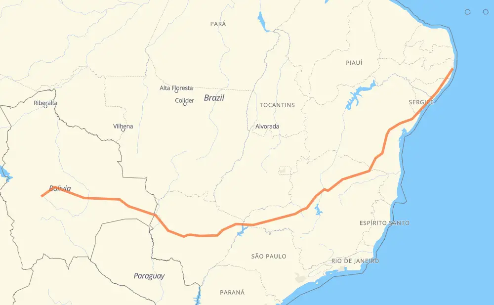
The distance from Llavini to UR-10 Ibura is 4,646 kilometers by road including 84 kilometers on motorways. Road takes approximately 52 hours and 34 minutes and goes through Vinto, Colcapirhua, Cochabamba, Corumba and Campo Grande.
How much does it cost to drive from Llavini to UR-10 Ibura?
Fuel cost:
553.8 GBP
This fuel cost is calculated as: (Route length 4,646 km / 100 km) * (Fuel consumption 8 L/100 km) * (Fuel price 1.49 GBP / L)
You can adjust fuel consumption and fuel price here.
How long is a car ride from Llavini to UR-10 Ibura?
Driving time:
52 h 34 min
This time is calculated for driving at the maximum permitted speed, taking into account traffic rules restrictions.
41 km with a maximum speed 110 km/h = 22 min
28 km with a maximum speed 100 km/h = 16 min
2,811 km with a maximum speed 96 km/h = 29 h 16 min
1,690 km with a maximum speed 80 km/h = 21 h 7 min
13 km with a maximum speed 70 km/h = 11 min
59 km with a maximum speed 60 km/h = 59 min
8 km with a maximum speed 50 km/h = 10 min
7 km with a maximum speed 40 km/h = 10 min
The calculated driving time does not take into account intermediate stops and traffic jams.
How far is Llavini to UR-10 Ibura by land?
The distance between Llavini and UR-10 Ibura is 4,646 km by road including 84 km on motorways.
Precise satellite coordinates of highways were used for this calculation. The start and finish points are the centers of Llavini and UR-10 Ibura respectively.
How far is Llavini to UR-10 Ibura by plane?
The shortest distance (air line, as the crow flies) between Llavini and UR-10 Ibura is 3,565 km.
This distance is calculated using the Haversine formula as a great-circle distance between two points on the surface of a sphere. The start and finish points are the centers of Llavini and UR-10 Ibura respectively. Actual distance between airports may be different.
How many hours is Llavini from UR-10 Ibura by plane?
Boeing 737 airliner needs 4 h 27 min to cover the distance of 3,565 km at a cruising speed of 800 km/h.
Small plane "Cessna 172" needs 16 h 12 min to flight this distance at average speed of 220 km/h.
This time is approximate and do not take into account takeoff and landing times, airport location and other real world factors.
How long is a helicopter ride from Llavini to UR-10 Ibura?
Fast helicopter "Eurocopter AS350" or "Hughes OH-6 Cayuse" need 14 h 51 min to cover the distance of 3,565 km at a cruising speed of 240 km/h.
Popular "Robinson R44" needs 16 h 58 min to flight this distance at average speed of 210 km/h.
This time is approximate and do not take into account takeoff and landing times, aerodrome location and other real world factors.
What city is halfway between Llavini and UR-10 Ibura?
The halfway point between Llavini and UR-10 Ibura is Prata. It is located about 40 km from the exact midpoint by road.
The distance from Prata to Llavini is 2,283 km and driving will take about 26 h 15 min. The road between Prata and UR-10 Ibura has length 2,363 km and will take approximately 26 h 18 min.
The other cities located close to halfway point:
Jardim Europa is in 2,363 km from Llavini and 2,283 km from UR-10 Ibura
Tocantins is in 2,366 km from Llavini and 2,280 km from UR-10 Ibura
Dona Zulmira is in 2,369 km from Llavini and 2,277 km from UR-10 Ibura
Where is Llavini in relation to UR-10 Ibura?
Llavini is located 3,565 km south-west of UR-10 Ibura.
Llavini has geographic coordinates: latitude -17.66623, longitude -66.41067.
UR-10 Ibura has geographic coordinates: latitude -8.13634, longitude -34.95122.
Which highway goes from Llavini to UR-10 Ibura?
The route from Llavini to UR-10 Ibura follows F4, BR-101, BR-365, BR-262, BR-116, BR-251, BR-497, MG-497, MS-377.