Distance between Loimersdorf and Mannersdorf am Leithagebirge
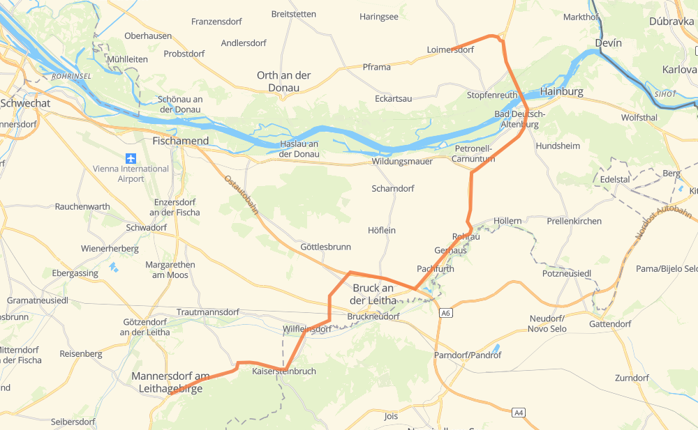
The distance from Loimersdorf to Mannersdorf am Leithagebirge is 45 kilometers by road including 5 kilometers on motorways. Road takes approximately 34 minutes and goes through Hainburg an der Donau, Bruck an der Leitha, Engelhartstetten, Petronell-Carnuntum, Gerhaus, Pachfurth and Kaisersteinbruch.
| Shortest distance by air | 29 km ✈️ |
| Car route length | 45 km 🚗 |
| Driving time | 34 min |
| Fuel amount | 3.6 L |
| Fuel cost | 5.4 GBP |
| Point | Distance | Time | Fuel | |
| Loimersdorf | 0 km | 00 min | 0.0 L | |
|
B3 3 km, 03 min
|
||||
| Engelhartstetten | 3 km | 03 min | 0.1 L | |
|
B3 B49 5 km, 03 min
|
||||
| Hainburg an der Donau | 8 km | 06 min | 0.5 L | |
|
B49 B9 4 km, 02 min
|
||||
| Petronell-Carnuntum | 12 km | 09 min | 0.9 L | |
|
B9 B211 8 km, 05 min
|
||||
| Gerhaus | 20 km | 14 min | 1.6 L | |
|
B211 2 km, 01 min
|
||||
| Pachfurth | 22 km | 16 min | 1.7 L | |
|
B211 7 km, 05 min
|
||||
| Bruck an der Leitha | 29 km | 21 min | 1.9 L | |
|
A4 L311 8 km, 05 min
|
||||
| Kaisersteinbruch | 37 km | 27 min | 2.8 L | |
|
L311 3 km, 02 min
|
||||
| Sommerein | 40 km | 30 min | 3.1 L | |
|
L2002 5 km, 04 min
|
||||
| Mannersdorf am Leithagebirge | 45 km | 34 min | 3.4 L | |
Frequently Asked Questions
How much does it cost to drive from Loimersdorf to Mannersdorf am Leithagebirge?
Fuel cost: 5.4 GBP
This fuel cost is calculated as: (Route length 45 km / 100 km) * (Fuel consumption 8 L/100 km) * (Fuel price 1.49 GBP / L)
You can adjust fuel consumption and fuel price here.
How long is a car ride from Loimersdorf to Mannersdorf am Leithagebirge?
Driving time: 34 min
This time is calculated for driving at the maximum permitted speed, taking into account traffic rules restrictions.
- 4 km with a maximum speed 112 km/h = 2 min
- 25 km with a maximum speed 96 km/h = 15 min
- 2 km with a maximum speed 80 km/h = 1 min
- 3 km with a maximum speed 70 km/h = 2 min
- 10 km with a maximum speed 50 km/h = 12 min
The calculated driving time does not take into account intermediate stops and traffic jams.
How far is Loimersdorf to Mannersdorf am Leithagebirge by land?
The distance between Loimersdorf and Mannersdorf am Leithagebirge is 45 km by road including 5 km on motorways.
Precise satellite coordinates of highways were used for this calculation. The start and finish points are the centers of Loimersdorf and Mannersdorf am Leithagebirge respectively.
What city is halfway between Loimersdorf and Mannersdorf am Leithagebirge?
The halfway point between Loimersdorf and Mannersdorf am Leithagebirge is Pachfurth.
The distance from Pachfurth to Loimersdorf is 22 km and driving will take about 16 min. The road between Pachfurth and Mannersdorf am Leithagebirge has length 23 km and will take approximately 18 min.
The other cities located close to halfway point:
Where is Loimersdorf in relation to Mannersdorf am Leithagebirge?
Loimersdorf is located 29 km north-east of Mannersdorf am Leithagebirge.
Loimersdorf has geographic coordinates: latitude 48.1743, longitude 16.84593.
Mannersdorf am Leithagebirge has geographic coordinates: latitude 47.97448, longitude 16.6038.