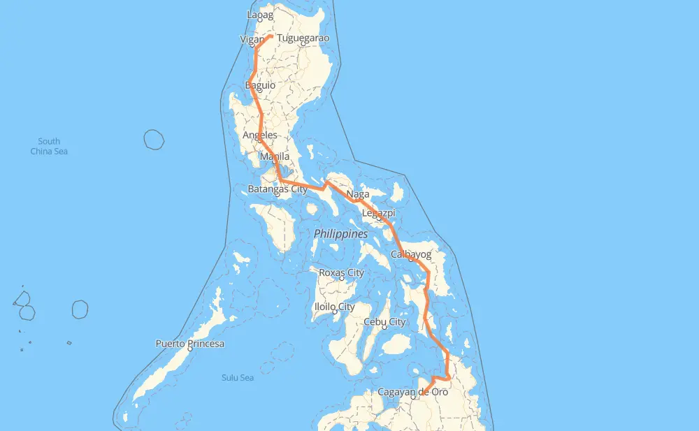
Distance between Malitbog and Tineg
The distance from Malitbog to Tineg is 1,824 kilometers by road including 255 kilometers on motorways. Road takes approximately 25 hours and 53 minutes and goes through Gingoog, Butuan, Surigao City, Tacloban, Catbalogan, Calbayog and Sorsogon City.
| Shortest distance by air | 1,113 km ✈️ |
| Car route length | 1,824 km 🚗 |
| Driving time | 25 h 53 min |
| Fuel amount | 145.9 L |
| Fuel cost | 218.9 GBP |
| Point | Distance | Time | Fuel | |
| Malitbog | 0 km | 00 min | 0.0 L | |
|
955 65 km, 50 min
|
||||
| Gingoog | 65 km | 50 min | 4.7 L | |
|
9 73 km, 1 h 12 min
|
||||
| Butuan | 138 km | 2 h 02 min | 10.8 L | |
|
9 AH26 120 km, 1 h 34 min
|
||||
| Surigao City | 258 km | 3 h 36 min | 20.5 L | |
|
1 228 km, 3 h 50 min
|
||||
| Tacloban | 486 km | 7 h 26 min | 38.6 L | |
|
1 100 km, 1 h 22 min
|
||||
| Catbalogan | 586 km | 8 h 49 min | 45.8 L | |
|
1 83 km, 1 h 14 min
|
||||
| Calbayog | 670 km | 10 h 04 min | 51.5 L | |
|
1 145 km, 2 h 42 min
|
||||
| Sorsogon City | 815 km | 12 h 46 min | 65.0 L | |
|
1 81 km, 59 min
|
||||
| Ligao | 896 km | 13 h 46 min | 71.3 L | |
|
1 61 km, 51 min
|
||||
| Naga | 957 km | 14 h 37 min | 76.2 L | |
|
1 301 km, 3 h 55 min
|
||||
| San Pablo | 1,258 km | 18 h 33 min | 100.1 L | |
|
1 AH26 34 km, 25 min
|
||||
| Calamba | 1,292 km | 18 h 58 min | 102.9 L | |
|
E2 6 km, 03 min
|
||||
| Cabuyao | 1,298 km | 19 h 02 min | 103.8 L | |
|
E2 3 km, 01 min
|
||||
| Santa Rosa | 1,301 km | 19 h 04 min | 103.9 L | |
|
E2 7 km, 03 min
|
||||
| Biñan | 1,308 km | 19 h 08 min | 104.3 L | |
|
E2 5 km, 03 min
|
||||
| San Pedro | 1,313 km | 19 h 11 min | 104.9 L | |
|
E2 E1 294 km, 3 h 25 min
|
||||
| San Fernando | 1,608 km | 22 h 37 min | 128.6 L | |
|
2 76 km, 1 h 07 min
|
||||
| Candon | 1,684 km | 23 h 44 min | 134.2 L | |
|
2 204 141 km, 2 h 08 min
|
||||
| Tineg | 1,824 km | 25 h 52 min | 144.1 L | |
Frequently Asked Questions
How much does it cost to drive from Malitbog to Tineg?
Fuel cost: 218.9 GBP
This fuel cost is calculated as: (Route length 1,824 km / 100 km) * (Fuel consumption 8 L/100 km) * (Fuel price 1.5 GBP / L)
You can adjust fuel consumption and fuel price here.
How long is a car ride from Malitbog to Tineg?
Driving time: 25 h 53 min
This time is calculated for driving at the maximum permitted speed, taking into account traffic rules restrictions.
- 245 km with a maximum speed 100 km/h = 2 h 26 min
- 176 km with a maximum speed 96 km/h = 1 h 49 min
- 5 km with a maximum speed 90 km/h = 3 min
- 967 km with a maximum speed 80 km/h = 12 h 5 min
- 19 km with a maximum speed 70 km/h = 16 min
- 242 km with a maximum speed 60 km/h = 4 h 2 min
- 87 km with a maximum speed 50 km/h = 1 h 44 min
- 25 km with a maximum speed 40 km/h = 38 min
- 6 km with a maximum speed 30 km/h = 11 min
- 52 km with a maximum speed 20 km/h = 2 h 34 min
The calculated driving time does not take into account intermediate stops and traffic jams.
How far is Malitbog to Tineg by land?
The distance between Malitbog and Tineg is 1,824 km by road including 255 km on motorways.
Precise satellite coordinates of highways were used for this calculation. The start and finish points are the centers of Malitbog and Tineg respectively.
How far is Malitbog to Tineg by plane?
The shortest distance (air line, as the crow flies) between Malitbog and Tineg is 1,113 km.
This distance is calculated using the Haversine formula as a great-circle distance between two points on the surface of a sphere. The start and finish points are the centers of Malitbog and Tineg respectively. Actual distance between airports may be different.
How many hours is Malitbog from Tineg by plane?
Boeing 737 airliner needs 1 h 23 min to cover the distance of 1,113 km at a cruising speed of 800 km/h.
Small plane "Cessna 172" needs 5 h 3 min to flight this distance at average speed of 220 km/h.
This time is approximate and do not take into account takeoff and landing times, airport location and other real world factors.
How long is a helicopter ride from Malitbog to Tineg?
Fast helicopter "Eurocopter AS350" or "Hughes OH-6 Cayuse" need 4 h 38 min to cover the distance of 1,113 km at a cruising speed of 240 km/h.
Popular "Robinson R44" needs 5 h 18 min to flight this distance at average speed of 210 km/h.
This time is approximate and do not take into account takeoff and landing times, aerodrome location and other real world factors.
What city is halfway between Malitbog and Tineg?
Where is Malitbog in relation to Tineg?
Malitbog is located 1,113 km south-east of Tineg.
Malitbog has geographic coordinates: latitude 8.53672, longitude 124.88126.
Tineg has geographic coordinates: latitude 17.78352, longitude 120.94364.
Which highway goes from Malitbog to Tineg?
The route from Malitbog to Tineg follows AH26, 1, E1, 2.
Other minor sections pass along the road:
- 68: 93 km
- 9: 81 km
- E2: 51 km
- 204: 46 km
- 955: 41 km
- 691: 39 km
- 609: 8 km
- 140: 5 km
- 673: 4 km
- 160: 4 km
- 608: 3 km
- 145: 2 km
- 161: 1 km