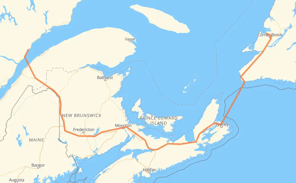
Distance between McIver's NL and Longue-Rive QC
The distance from McIver's to Longue-Rive is 1,530 kilometers by road including 817 kilometers on motorways. Road takes approximately 23 hours and 37 minutes and goes through Corner Brook, Moncton, Fredericton, Gillams, Meadows, Codroy Valley and Port Aux Basques.
| Shortest distance by air | 815 km ✈️ |
| Car route length | 1,530 km 🚗 |
| Driving time | 23 h 37 min |
| Fuel amount | 122.4 L |
| Fuel cost | 182.4 GBP |
| Point | Distance | Time | Fuel | |
| McIver's | 0 km | 00 min | 0.0 L | |
|
440 15 km, 15 min
|
||||
| Gillams | 15 km | 15 min | 0.0 L | |
|
440 38 km, 30 min
|
||||
| Corner Brook | 53 km | 46 min | 2.8 L | |
|
1 180 km, 1 h 52 min
|
||||
| Codroy Valley | 233 km | 2 h 38 min | 17.1 L | |
|
1 28 km, 17 min
|
||||
| Port Aux Basques | 261 km | 2 h 56 min | 20.6 L | |
|
1 NS 105 239 km, 9 h 31 min
|
||||
| Baddeck | 500 km | 12 h 28 min | 39.4 L | |
|
NS 105 18 km, 11 min
|
||||
| Wagmatcook First Nation | 518 km | 12 h 39 min | 40.9 L | |
|
NS 105 TCH 398 km, 3 h 50 min
|
||||
| Moncton | 915 km | 16 h 30 min | 72.5 L | |
|
2 170 km, 1 h 32 min
|
||||
| Fredericton | 1,085 km | 18 h 03 min | 86.4 L | |
|
2 455 km, 5 h 34 min
|
||||
| Longue-Rive | 1,540 km | 23 h 37 min | 123.0 L | |
Frequently Asked Questions
How much does it cost to drive from McIver's to Longue-Rive?
Fuel cost: 182.4 GBP
This fuel cost is calculated as: (Route length 1,530 km / 100 km) * (Fuel consumption 8 L/100 km) * (Fuel price 1.49 GBP / L)
You can adjust fuel consumption and fuel price here.
How long is a car ride from McIver's to Longue-Rive?
Driving time: 23 h 37 min
This time is calculated for driving at the maximum permitted speed, taking into account traffic rules restrictions.
- 678 km with a maximum speed 110 km/h = 6 h 9 min
- 135 km with a maximum speed 100 km/h = 1 h 21 min
- 440 km with a maximum speed 96 km/h = 4 h 34 min
- 2 km with a maximum speed 90 km/h = 1 min
- 49 km with a maximum speed 80 km/h = 36 min
- 5 km with a maximum speed 70 km/h = 4 min
- 26 km with a maximum speed 50 km/h = 31 min
- 206 km with a maximum speed 20 km/h = 10 h 18 min
The calculated driving time does not take into account intermediate stops and traffic jams.
How far is McIver's to Longue-Rive by land?
The distance between McIver's and Longue-Rive is 1,530 km by road including 817 km on motorways.
Precise satellite coordinates of highways were used for this calculation. The start and finish points are the centers of McIver's and Longue-Rive respectively.
How far is McIver's to Longue-Rive by plane?
The shortest distance (air line, as the crow flies) between McIver's and Longue-Rive is 815 km.
This distance is calculated using the Haversine formula as a great-circle distance between two points on the surface of a sphere. The start and finish points are the centers of McIver's and Longue-Rive respectively. Actual distance between airports may be different.
How many hours is McIver's from Longue-Rive by plane?
Boeing 737 airliner needs 1 h 1 min to cover the distance of 815 km at a cruising speed of 800 km/h.
Small plane "Cessna 172" needs 3 h 42 min to flight this distance at average speed of 220 km/h.
This time is approximate and do not take into account takeoff and landing times, airport location and other real world factors.
How long is a helicopter ride from McIver's to Longue-Rive?
Fast helicopter "Eurocopter AS350" or "Hughes OH-6 Cayuse" need 3 h 23 min to cover the distance of 815 km at a cruising speed of 240 km/h.
Popular "Robinson R44" needs 3 h 52 min to flight this distance at average speed of 210 km/h.
This time is approximate and do not take into account takeoff and landing times, aerodrome location and other real world factors.
What city is halfway between McIver's and Longue-Rive?
The halfway point between McIver's and Longue-Rive is Masstown.
The distance from Masstown to McIver's is 765 km and driving will take about 15 h 6 min. The road between Masstown and Longue-Rive has length 765 km and will take approximately 8 h 30 min.
The other cities located close to halfway point:
Where is McIver's in relation to Longue-Rive?
McIver's is located 815 km east of Longue-Rive.
McIver's has geographic coordinates: latitude 49.07699, longitude -58.12135.
Longue-Rive has geographic coordinates: latitude 48.57615, longitude -69.23035.
Which highway goes from McIver's to Longue-Rive?
The route from McIver's to Longue-Rive follows TCH, 2, NS 104, 1, NS 105.
Other minor sections pass along the road:
- 293: 49 km
- 440: 42 km
- 85: 39 km
- 138: 32 km
- 232: 17 km
- 7: 11 km
- 105: 6 km
- NS 4: 4 km
- NB 2: 2 km