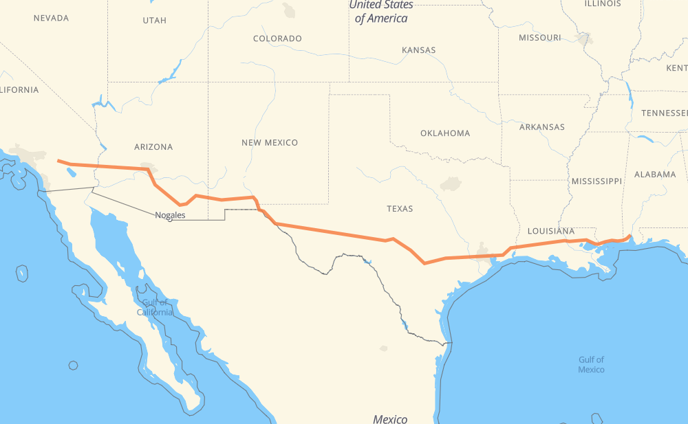
The distance from Mobile to Palm Springs is 3,075 kilometers by road including 3,048 kilometers on motorways. Road takes approximately 28 hours and 56 minutes and goes through Biloxi, Gulfport, Denham Springs, Baton Rouge, Lake Charles, Beaumont and Houston.
How much does it cost to drive from Mobile to Palm Springs?
Fuel cost:
364 GBP
This fuel cost is calculated as: (Route length 3,075 km / 100 km) * (Fuel consumption 8 L/100 km) * (Fuel price 1.48 GBP / L)
You can adjust fuel consumption and fuel price here.
How long is a car ride from Mobile to Palm Springs?
Driving time:
28 h 56 min
This time is calculated for driving at the maximum permitted speed, taking into account traffic rules restrictions.
2,122 km with a maximum speed 112 km/h = 18 h 56 min
271 km with a maximum speed 105 km/h = 2 h 35 min
350 km with a maximum speed 100 km/h = 3 h 30 min
113 km with a maximum speed 97 km/h = 1 h 10 min
13 km with a maximum speed 96 km/h = 8 min
9 km with a maximum speed 89 km/h = 6 min
4 km with a maximum speed 80 km/h = 3 min
182 km with a maximum speed 80 km/h = 2 h 16 min
7 km with a maximum speed 72 km/h = 5 min
2 km with a maximum speed 64 km/h = 1 min
2 km with a maximum speed 56 km/h = 1 min
The calculated driving time does not take into account intermediate stops and traffic jams.
How far is Mobile to Palm Springs by land?
The distance between Mobile and Palm Springs is 3,075 km by road including 3,048 km on motorways.
Precise satellite coordinates of highways were used for this calculation. The start and finish points are the centers of Mobile and Palm Springs respectively.
How far is Mobile to Palm Springs by plane?
The shortest distance (air line, as the crow flies) between Mobile and Palm Springs is 2,694 km.
This distance is calculated using the Haversine formula as a great-circle distance between two points on the surface of a sphere. The start and finish points are the centers of Mobile and Palm Springs respectively. Actual distance between airports may be different.
How many hours is Mobile from Palm Springs by plane?
Boeing 737 airliner needs 3 h 22 min to cover the distance of 2,694 km at a cruising speed of 800 km/h.
Small plane "Cessna 172" needs 12 h 14 min to flight this distance at average speed of 220 km/h.
This time is approximate and do not take into account takeoff and landing times, airport location and other real world factors.
How long is a helicopter ride from Mobile to Palm Springs?
Fast helicopter "Eurocopter AS350" or "Hughes OH-6 Cayuse" need 11 h 13 min to cover the distance of 2,694 km at a cruising speed of 240 km/h.
Popular "Robinson R44" needs 12 h 49 min to flight this distance at average speed of 210 km/h.
This time is approximate and do not take into account takeoff and landing times, aerodrome location and other real world factors.
What city is halfway between Mobile and Palm Springs?
The halfway point between Mobile and Palm Springs is Fort Stockton. It is located about 26 km from the exact midpoint by road.
The distance from Fort Stockton to Mobile is 1,563 km and driving will take about 14 h 32 min. The road between Fort Stockton and Palm Springs has length 1,511 km and will take approximately 14 h 23 min.